Washington, US
Washington: Located in the Pacific Northwest region of the United States, Washington is known for its diverse landscapes, including the Olympic Mountains and the Columbia River.
About
Washington became the 42nd state admitted to the Union on November 11, 1889. Its diverse landscape and economy support a growing population.
Geography and Climate
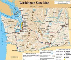
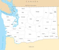
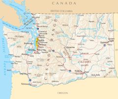
Washington covers 71,362 square miles of mountains, forests, coastal regions and arid areas. It shares a border with Canada and borders Oregon, Idaho and the Pacific Ocean. Prominent geographical features include the volcanic Mount St. Helens and Mount Rainier along with the Columbia River.
The climate ranges from rainy in the west to semi-arid in the east. Summers are mild while winters are cold with significant snow in mountain areas.
Economy and Industry
Major industries include aerospace, technology, forestry, agriculture and tourism. Many global companies started in Washington like Microsoft, Amazon, Starbucks and Costco. It is a top producer of lumber and apples. The Hanford Site supported Cold War nuclear projects.
Popular tourist attractions are the Space Needle, Mount Rainier National Park and Pike Place Market.
Culture and Demographics
Washington has about 7.5 million residents with the largest ethnicity being white at 67%, followed by Hispanic/Latino and Asian. Pacific Northwest culture is laidback and progressive with Native American influences. Seattle is known as a vibrant hub for arts and innovation.
Government and Politics
The capital is Olympia while Seattle is the largest city. The current governor is Jay Inslee, Democrat. Washington has voted for Democratic presidential candidates since 1988.
Washington is known for its rainy climate, major technology companies and Pacific Northwest culture. It has a diverse landscape supporting a strong forestry industry and agriculture. As both a coastal and mountainous state, Washington offers many natural highlights.

State Snapshot
Washington at a glance
Washington currently has 362 quality-checked populated place pages and 39 county pages linked on MapSof.
Mapped cities & towns
362
These counts use a stricter populated-place filter so the main lists stay focused on real city and town pages.
County pages
39
Open related pagesLargest city
SeattlePopulation 769,714
Top linked places
Quick Facts about Washington
| Population | 7,693,612 |
| Country | United States of America |
| Area | 184827 km2 |
| Water as percent of area | 6.79% |
| Land as percent of area | 93.21% |
| Latitude & Longitude | 47.5001,-120.5015 |
| Legislative body | Washington State Legislature |
| Named for | George Washington |
| Altitude | 1,706 feet / 520 meters |
| Capital | Olympia |
| Establishment | November 11, 1889 (136 years ago) |
| Time Zone | UTC−08:00, America/Los_Angeles |
| Local time | 19:59:30 (8th June 2026) |

Geography
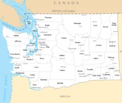
Washington is located at 47°30'0"N 120°30'5"W (47.5001200, -120.5014700). It has 3 neighbors: Idaho, Oregon and British Columbia.
Washington map
The largest city of Washington is Seattle with a population of 769,714. Other cities include, Spokane population 222,050, Tacoma population 219,945, Vancouver population 186,192 and Bellevue population 148,073. See all Washington cities & populated places.
Largest Cities in Washington (more)
Cities, Towns, Villages, Neighborhoods & Other Populated Places in Washington.
| City Name | County | Population |
|---|---|---|
| Seattle | King | 769,714 |
| Spokane | Spokane | 222,050 |
| Tacoma | Pierce | 219,945 |
| Vancouver | Clark | 186,192 |
| Bellevue | King | 148,073 |
| Kent | King | 130,676 |
| Everett | Snohomish | 112,482 |
| Spokane Valley | Spokane | 102,893 |
| Renton | King | 101,494 |
| Federal Way | King | 96,307 |
| Kirkland | King | 95,431 |
| Yakima | Yakima | 94,322 |
| Bellingham | Whatcom | 93,955 |
| Kennewick | Benton | 84,515 |
| Auburn | King | 81,024 |
| Pasco | Franklin | 77,095 |
Show more Washington cities and populated places
Official website of Washington
Official Website- Adams County
- Grays Harbor County
- Spokane County
- Cowlitz County
- Whatcom County
- Benton County
- Kittitas County
- Klickitat County
- Skagit County
- Okanogan County
- Snohomish County
- Columbia County
- Franklin County
- King County
- Stevens County
- Yakima County
- Wahkiakum County
- Walla Walla County
- Asotin County
- Jefferson County
- Pacific County
- Thurston County
- Kitsap County
- Lincoln County
- San Juan County
- Chelan County
- Douglas County
- Clark County
- Garfield County
- Lewis County
- Grant County
- Pierce County
- Pend Oreille County
- Whitman County
- Clallam County
- Island County
- Mason County
- Skamania County
- Ferry County
Demographics
| Year | Population | % Change | Method |
|---|---|---|---|
| 1800 | 8,144 | - | estimation process |
| 1810 | 15,471 | 47.36% | estimation process |
| 1820 | 23,336 | 33.7% | estimation process |
| 1830 | 30,261 | 22.88% | census |
| 1840 | 33,745 | 10.32% | census |
| 1850 | 51,687 | 34.71% | estimation process |
| 1860 | 75,080 | 31.16% | estimation process |
| 1870 | 131,700 | 42.99% | estimation process |
| 1880 | 177,624 | 25.85% | census |
| 1890 | 230,392 | 22.9% | census |
| 1900 | 278,718 | 17.34% | census |
| 1908 | 321,000 | 13.17% | census |
| 1910 | 331,069 | 3.04% | census |
| 1918 | 418,000 | 20.8% | census |
| 1920 | 437,571 | 4.47% | census |
| 1930 | 486,869 | 10.13% | census |
| 1940 | 663,091 | 26.58% | 1940 United States Census |
| 1950 | 802,178 | 17.34% | census |
| 1960 | 763,956 | -5% | census |
| 1970 | 756,510 | -0.98% | census |
| 1980 | 638,333 | -18.51% | census |
| 1990 | 606,900 | -5.18% | census |
| 2000 | 572,059 | -6.09% | census |
| 2010 | 6,724,540 | 91.49% | census |
| 2011 | 6,826,627 | 1.5% | estimation process |
| 2012 | 6,897,058 | 1.02% | estimation process |
| 2013 | 6,963,985 | 0.96% | estimation process |
| 2014 | 7,054,655 | 1.29% | estimation process |
| 2015 | 7,163,657 | 1.52% | estimation process |
| 2016 | 7,294,771 | 1.8% | estimation process |
| 2017 | 7,423,362 | 1.73% | estimation process |
| 2018 | 7,523,869 | 1.34% | estimation process |
| 2019 | 7,614,893 | 1.2% | estimation process |
| 2020 | 7,693,612 | 1.02% | estimation process |
People born in Washington (109)
People born in Washington, including writer Adora Svitak, artist David Ireland, actress Alexys Nycole Sánchez, .
More notable people
- Scott Forstall (American software engineer) he was born in 01/01/1968
- Chief Seattle (Duwamish chief) he was born in 01/01/1786
- Red Badgro (Player of American football) he was born in 01/12/1902
- Pat Murphy (American author of science fiction and fantasy novels) she was born in 09/03/1955
- Bill Crow (American bassist) he was born in 27/12/1927
- Sol Lesser (film producer) he was born in 17/02/1890
- Julia Quinn (American novelist) she was born in 12/01/1970
- Lisa Jackson (American romance novelist) she was born in 01/01/1951
- David Ray Griffin (American philosopher) he was born in 08/08/1939
- Laurel Rose Willson (Disgraced American writer) she was born in 18/08/1941
- Carole Nelson Douglas (American writer) she was born in 11/05/1944
- Bob Crosby (American dixieland bandleader and vocalist (1913-1993)) he was born in 25/08/1913
- Eleanor Columbus (actress from the United States) she was born in 12/10/1989
- G. C. Edmondson (American writer) he was born in 11/10/1922
- Cait London (American writer) she was born in 01/01/2000
- Don Lanphere (American musician) he was born in 26/06/1928
- Joe S. Bain (American economist) he was born in 12/07/1912
- Donald Trunkey (US physician) he was born in 01/01/1937
Other places with the same name (29)
- Washington, Utah city in Washington County, Kansas with a population of 31,939 people.
- Washington, Michigan township in Macomb County, Michigan with a population of 28,846 people.
- Washington, Illinois city in Tazewell County, Illinois with a population of 16,395 people.
- Washington, Missouri city in Franklin County, Missouri with a population of 14,243 people.
- Washington, Indiana city in Daviess County, Indiana, United States with a population of 12,635 people.
- Washington, North Carolina city in Beaufort County, North Carolina, United States of America with a population of 9,487 people.
- Washington, Iowa city in Franklin County, Missouri with a population of 7,206 people.
- Washington, New Jersey borough in Warren County, New Jersey, United States with a population of 6,498 people.
- Washington, New Jersey borough in Warren County, New Jersey, United States with a population of 6,459 people.
- Washington, Georgia city in and county seat of Wilkes County, Georgia, United States with a population of 3,907 people.
- Washington, Connecticut town in Connecticut with a population of 3,419 people.
- Washington, Pennsylvania city in Pennsylvania with a population of 2,703 people.
- Washington, Maine town in Maine with a population of 1,520 people.
- Washington, Wisconsin civil town in Door County, Wisconsin with a population of 1,504 people.
- Washington, West Virginia census-designated place in Wood County, West Virginia with a population of 1,175 people.
- Washington, Iowa city in Washington County, Kansas with a population of 1,131 people.
- Washington, Pennsylvania city in Washington County, Kansas with a population of 1,131 people.
- Washington, Texas city in Washington County, Kansas with a population of 1,131 people.
- Washington, New Hampshire town in New Hampshire with a population of 1,104 people.
- Washington, Kansas city in Washington County, Kansas with a population of 1,065 people.
- Washington, Vermont town in Orange County, Vermont with a population of 1,014 people.
- Washington, Louisiana town in St. with a population of 903 people.
- Washington, Minnesota county in Minnesota, United States with a population of 752 people.
- Washington, Oklahoma town in Oklahoma with a population of 601 people.
- Washington, Massachusetts town in Massachusetts with a population of 541 people.
- Washington, California town in California with a population of 185 people.
- Washington, Arkansas city in Hempstead County, Arkansas, United States with a population of 165 people.
- Washington, Nebraska city in Washington County, Kansas with a population of 161 people.
- Washington, Virginia village in Virginia with a population of 122 people.
Washington Counties (more)
King County

county in the state of Washington, United States
Pierce County

county in the state of Washington, United States
Snohomish County

county in the state of Washington, United States
| County Name | Population |
|---|---|
| King County | 2,274,315 |
| Pierce County | 913,890 |
| Snohomish County | 830,393 |
| Spokane County | 528,225 |
| Clark County | 496,865 |
| Thurston County | 294,074 |
| Kitsap County | 272,787 |
| Yakima County | 251,879 |
| Whatcom County | 231,016 |
| Benton County | 206,426 |
| Skagit County | 130,789 |
| Cowlitz County | 111,371 |
| Grant County | 99,377 |
| Franklin County | 97,075 |
| Island County | 86,014 |
| Lewis County | 82,109 |
Show more Washington counties
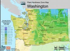
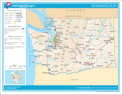
Map & Images (more maps)
Map of Washington Na 1
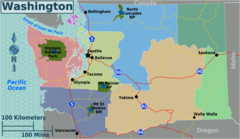
Washington Regions Map
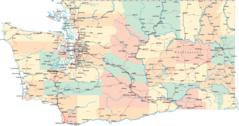
Washington Road Map
Washington State Map
Washington Flag Map
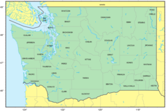
Counties Map of Washington
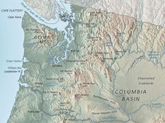
Washington Physical Map
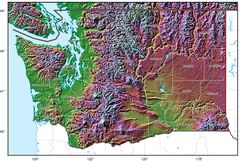
Washington Relief Map
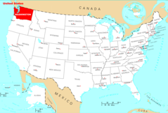
Where Is Washington Located
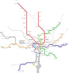
Washington Metro Map
Washington Cities And Towns
Washington County Map
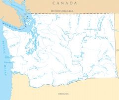
Washington Rivers And Lakes
Washington Reference Map