Karachi, Sindh
Karachi: Located on the Arabian Sea coast, this Pakistani metropolis is the country's largest city and principal seaport.
About
Quick Facts about Karachi
| Population | 14,910,352 |
| Country | Dominion of Pakistan, Pakistan, Kalhora Dynasty, Talpur dynasty, Company rule in Ind, British India |
| State | Sindh (Pakistan) |
| Postal code | 74000–75900 |
| Plate code | KC, KA |
| Phone Area Codes | 021 |
| Area | 3527000000 km2 |
| Official name | کراچی |
| Latitude & Longitude | 24.8608,67.0104 |
| Legislative body | Karachi Metropolitan Corporation |
| Official language | Urdu |
| Altitude | 26 feet / 8 meters |
| Capital | Gulshan Town |
| Capital city | Karachi is capital of Sind Province, West Pakistan, Dominion of Pakistan |
| Establishment | January 01, 1729 (297 years ago) |
| Time Zone | UTC+05:00 |
| Local time | 15:13:38 (15th June 2026) |
Geography
Karachi is located at 24°51'39"N 67°0'37"E (24.8608000, 67.0104000).
Karachi map
Click "full screen"  icon to open full mode. View satellite images
Official website of Karachi
Official Website- Beirut
- Chicago
- Delhi
- Dhaka
- Dubai
- Houston
- Istanbul
- Jeddah
- Kolkata
- Kuala Lumpur
- London
- Manama
- Mashhad
- Mumbai
- Port Louis
- Pristina
- Qom
- Shanghai (1984 )
- Tashkent
Demographics
| Year | Population | % Change | Method |
|---|---|---|---|
| 2016 | 23,545,000 | - | metropolitan area |
| 2017 | 14,910,352 | -57.91% | census |
Map of countries with a smaller population than Karachi
Carachi, KHI, Karaaji, Karaces, Karachi - krachy, Karachi - كراچى, Karachy, Karaci, Karacio, Karacis, Karacsi, Karaczi, Karanchi, Karatschi, Karatsi, Karatsji, Karatxi, Karaçi, Karaĉio, Karači, Karačis, Karačės, Karochi, Karáči, Karáčí, Karāchi, Karāči, Keraci, Keraçî, Kurrachee, Kurrachi, Kəraçi, ka la qi, ka ra ci, kalachi, karaaci, karacci, karatshy, ke la chi, krachy, kratshy, pechs, qrʼzy, Καράτσι, Карачи, Карачы, Карачі, Կարաչի, קאראטשי, קראצי, كاراتشى, كاراچى, كراتشي, کراچی, کراچۍ, کَرٲچی, کەراچی, ڪراچي, ކަރާޗީ, कराची, করাচী, কৰাচী, ਕਰਾਚੀ, કરાચી, କରାଚୀ, கராச்சி, కరాచీ, ಕರಾಚಿ, കറാച്ചി, การาจี, ཀ་ར་ཆི, ကရာချိမြို့, კარაჩი, ከራቺ, カラチ, カラーチー, 卡拉奇, 喀拉蚩, 카라치
Map & Images (more maps)
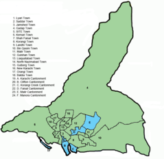
Karachi Administrative Divisions
820 x 796
- 49,129k -
png
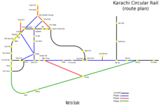
Karachi Circular Rail Route
2000 x 1298
- 52,000k -
png
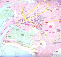
Karachi City Center
980 x 915
- 92,763k -
jpg
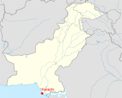
Location of Karachi Pakistan Map
1800 x 1438
- 168,799k -
png