Belgium (Kingdom of Belgium), BE
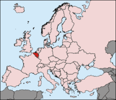
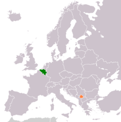
Belgium: Located in Western Europe, it borders France, Germany, Luxembourg, and the Netherlands.
About

Country Snapshot
Kingdom of Belgium at a glance
Kingdom of Belgium currently has 464 quality-checked populated place pages and 3 state or regional pages linked on MapSof.
Mapped cities & towns
464
These counts use a stricter populated-place filter so the main lists stay focused on real city and town pages.
States & regions
3
Open related pagesLargest city
AntwerpPopulation 529,247
Top linked places
Quick Facts about Kingdom of Belgium
| Population | 11,825,551 |
| Country | Belgium |
| Plate code | B |
| Area | 30528 km2 |
| Official name | Kraljevina Belgija, le Royaume de Belgique, Royaume de Belgique, Belgické království, Koninkrijk België, Königreich Belgien, Kingdom of Belgium |
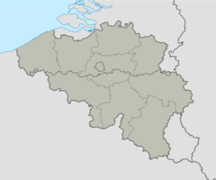
| Has part | German-speaking Community of Belgium, French Community of Belgium, Flemish Community, Brussels-Capital Region, Wallonia, Flanders |
| Water as percent of area | 0.8% |
| Land as percent of area | 99.2% |
| Continent | Europe |
| Annual number of weddings | 44725, 45005, 44858 |
| Easternmost point | Point(6.40743256 50.3358193) |
| Northernmost point | Point(4.77 51.5) |
| Latitude & Longitude | 50.8333,4.0000 |
| Patron saint | Joseph |
| Legislative body | Belgian Federal Parliament |
| Named for | Belgae |
| Official language | Dutch, German, French |
| Capital | Brussels |
| Establishment | October 04, 1830 (195 years ago) |
| Time Zone | Europe/Brussels, Central European Time, UTC+02:00, UTC+01:00, Central European Summer Time |
| Local time | 00:46:17 (10th June 2026) |

Geography
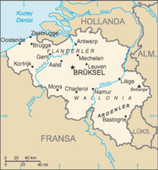
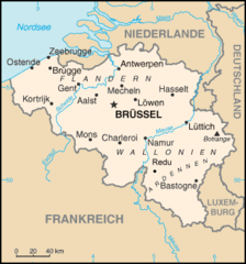
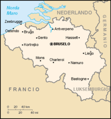
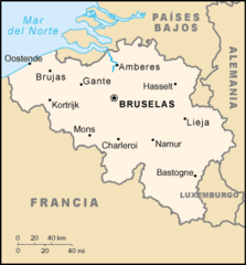
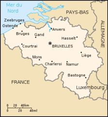
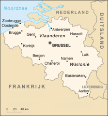
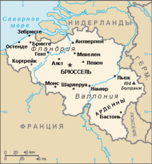
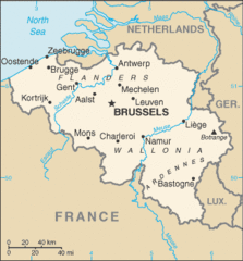
Kingdom of Belgium is located at 50°49'60"N 4°0'0"E (50.8333333, 4.0). It has 4 neighbors: Netherlands, Germany, Luxembourg and France.
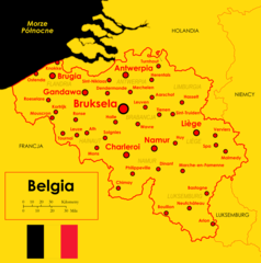
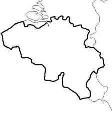
Belgium map
The largest city of Kingdom of Belgium is Charleroi with a population of 201,816. Other cities include, Liège population 196,623, Brussels population 185,103, Namur population 110,939 and Mons population 95,299. See all Kingdom of Belgium cities & populated places.
Compare Kingdom of Belgium with
- German-speaking Community of Belgium
- Wallonia
- Flemish Community
- Brussels-Capital Region
- Flemish Region
- French Community of Belgium
Demographics
| Year | Population | % Change | Method |
|---|---|---|---|
| 1960 | 9,153,489 | - | census |
| 1961 | 9,183,948 | 0.33% | census |
| 1962 | 9,220,578 | 0.4% | census |
| 1963 | 9,289,770 | 0.74% | census |
| 1964 | 9,378,113 | 0.94% | census |
| 1965 | 9,463,667 | 0.9% | census |
| 1966 | 9,527,807 | 0.67% | census |
| 1967 | 9,580,991 | 0.56% | census |
| 1968 | 9,618,756 | 0.39% | census |
| 1969 | 9,646,032 | 0.28% | census |
| 1970 | 9,655,549 | 0.1% | census |
| 1971 | 9,673,162 | 0.18% | census |
| 1972 | 9,711,115 | 0.39% | census |
| 1973 | 9,741,720 | 0.31% | census |
| 1974 | 9,772,419 | 0.31% | census |
| 1975 | 9,800,700 | 0.29% | census |
| 1976 | 9,818,227 | 0.18% | census |
| 1977 | 9,830,358 | 0.12% | census |
| 1978 | 9,839,534 | 0.09% | census |
| 1979 | 9,848,382 | 0.09% | census |
| 1980 | 9,859,242 | 0.11% | census |
| 1981 | 9,858,982 | -0% | census |
| 1982 | 9,856,303 | -0.03% | census |
| 1983 | 9,855,520 | -0.01% | census |
| 1984 | 9,855,372 | -0% | census |
| 1985 | 9,858,308 | 0.03% | census |
| 1986 | 9,861,823 | 0.04% | census |
| 1987 | 9,870,234 | 0.09% | census |
| 1988 | 9,901,664 | 0.32% | census |
| 1989 | 9,937,697 | 0.36% | census |
| 1990 | 9,967,379 | 0.3% | census |
| 1991 | 10,004,486 | 0.37% | census |
| 1992 | 10,045,158 | 0.4% | census |
| 1993 | 10,084,475 | 0.39% | census |
| 1994 | 10,115,603 | 0.31% | census |
| 1995 | 10,136,811 | 0.21% | census |
| 1996 | 10,156,637 | 0.2% | census |
| 1997 | 10,181,245 | 0.24% | census |
| 1998 | 10,203,008 | 0.21% | census |
| 1999 | 10,226,419 | 0.23% | census |
| 2000 | 10,251,250 | 0.24% | census |
| 2001 | 10,286,570 | 0.34% | census |
| 2002 | 10,332,785 | 0.45% | census |
| 2003 | 10,376,133 | 0.42% | census |
| 2004 | 10,396,421 | 0.2% | census |
| 2005 | 10,478,617 | 0.78% | census |
| 2006 | 10,547,958 | 0.66% | census |
| 2007 | 10,584,534 | 0.35% | census |
| 2008 | 10,709,973 | 1.17% | census |
| 2009 | 10,753,080 | 0.4% | census |
| 2010 | 10,839,905 | 0.8% | census |
| 2011 | 10,951,266 | 1.02% | census |
| 2012 | 11,128,246 | 1.59% | census |
| 2013 | 11,182,817 | 0.49% | census |
| 2014 | 11,150,516 | -0.29% | census |
| 2015 | 11,274,196 | 1.1% | (Worldbank) |
| 2016 | 11,331,422 | 0.51% | (Worldbank) |
| 2017 | 11,372,068 | 0.36% | census |
| 2018 | 11,427,054 | 0.48% | (Worldbank) |
| 2019 | 11,431,406 | 0.04% | census |
| 2026 | 11,825,551 | 3.33% |
Other places with the same name (2)
- Belgium, Wisconsin village in Ozaukee County, Wisconsin with a population of 1,444 people.
- Belgium, Illinois village in Illinois, United States with a population of 362 people.
Map & Images (more maps)
733px Belgium Provinces Regions2
Be Redu Map
Be Map Eo
Be Map Es
Be Map Fr
Be Map Nl
Be Map Ru

Be Stubmap

Belgie Mapa
Belgien Pos
Belgii
Belgique Vierge
Belgique Communes589 Provinces10
Belgium Kosovo Locator 2
Belgium Clearmap
Belgium Location Map (infobox Belgische Deelgemeente)
Belgium Relief
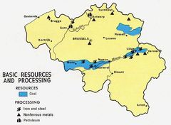
Belgium Resources 1968
Belgium Sm 2008
Belgium Stub