Aruba, AW
Aruba: island country in the Caribbean, part of the Kingdom of the Netherlands
About

Country Snapshot
Aruba at a glance
Aruba currently has 1 quality-checked populated place pages and 0 state or regional pages linked on MapSof.
Mapped cities & towns
1
These counts use a stricter populated-place filter so the main lists stay focused on real city and town pages.
States & regions
0
Open related pagesLargest city
OranjestadPopulation 34,980
Top linked places
Quick Facts about Aruba
| Population | 107,566 |
| Country | Kingdom of the Netherlands, Aruba |
| Area | 178.92 km2 |
| Continent | South America |
| Latitude & Longitude | 12.5000,-69.9667 |
| Legislative body | Estates of Aruba |
| Official language | Papiamento, Dutch |
| Altitude | 102 feet / 31 meters |
| Capital | Oranjestad |
| Establishment | January 01, 1986 (40 years ago) |
| Time Zone | UTC−04:00, Atlantic Time Zone, America/Aruba |
| Local time | 13:48:41 (9th June 2026) |

Dutch Buildings Oranjestad '4901401297' image
Geography
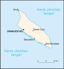
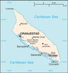
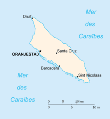
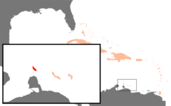
Aruba is located at 12°30'0"N 69°58'0"W (12.5000000, -69.9666700).
Aruba map
Click "full screen"  icon to open full mode. View satellite images
The largest city of Aruba is Oranjestad with a population of 34,980. . See all Aruba cities & populated places.
Official website of Aruba
Official WebsiteDemographics
| Year | Population | % Change | Method |
|---|---|---|---|
| 1960 | 54,208 | - | census |
| 1961 | 55,435 | 2.21% | census |
| 1962 | 56,226 | 1.41% | census |
| 1963 | 56,697 | 0.83% | census |
| 1964 | 57,029 | 0.58% | census |
| 1965 | 57,360 | 0.58% | census |
| 1966 | 57,712 | 0.61% | census |
| 1967 | 58,049 | 0.58% | census |
| 1968 | 58,385 | 0.58% | census |
| 1969 | 58,724 | 0.58% | census |
| 1970 | 59,065 | 0.58% | census |
| 1971 | 59,438 | 0.63% | census |
| 1972 | 59,849 | 0.69% | census |
| 1973 | 60,239 | 0.65% | census |
| 1974 | 60,525 | 0.47% | census |
| 1975 | 60,655 | 0.21% | census |
| 1976 | 60,589 | -0.11% | census |
| 1977 | 60,366 | -0.37% | census |
| 1978 | 60,106 | -0.43% | census |
| 1979 | 59,978 | -0.21% | census |
| 1980 | 60,096 | 0.2% | census |
| 1981 | 60,567 | 0.78% | census |
| 1982 | 61,344 | 1.27% | census |
| 1983 | 62,204 | 1.38% | census |
| 1984 | 62,831 | 1% | census |
| 1985 | 63,028 | 0.31% | census |
| 1986 | 62,644 | -0.61% | census |
| 1987 | 61,835 | -1.31% | census |
| 1988 | 61,077 | -1.24% | census |
| 1989 | 61,032 | -0.07% | census |
| 1990 | 62,148 | 1.8% | census |
| 1991 | 64,623 | 3.83% | census |
| 1992 | 68,235 | 5.29% | census |
| 1993 | 72,498 | 5.88% | census |
| 1994 | 76,700 | 5.48% | census |
| 1995 | 80,326 | 4.51% | census |
| 1996 | 83,195 | 3.45% | census |
| 1997 | 85,447 | 2.64% | census |
| 1998 | 87,276 | 2.1% | census |
| 1999 | 89,004 | 1.94% | census |
| 2000 | 90,858 | 2.04% | census |
| 2001 | 92,894 | 2.19% | census |
| 2002 | 94,995 | 2.21% | census |
| 2003 | 97,015 | 2.08% | census |
| 2004 | 98,742 | 1.75% | census |
| 2005 | 100,031 | 1.29% | census |
| 2006 | 100,830 | 0.79% | census |
| 2007 | 101,219 | 0.38% | census |
| 2008 | 101,344 | 0.12% | census |
| 2009 | 101,418 | 0.07% | census |
| 2010 | 101,597 | 0.18% | census |
| 2011 | 101,932 | 0.33% | census |
| 2012 | 102,384 | 0.44% | census |
| 2013 | 102,911 | 0.51% | census |
| 2014 | 103,774 | 0.83% | |
| 2015 | 104,341 | 0.54% | |
| 2016 | 104,872 | 0.51% | |
| 2017 | 105,366 | 0.47% | |
| 2018 | 105,845 | 0.45% | |
| 2019 | 112,309 | 5.76% | census |
| 2026 | 107,566 | -4.41% |
'Alupa, Aroba, Arobà, Aroumpa, Aruba nutome, Arubae, Arubha, Arubo, Aruuba, Arúba, Arûba, Country of Aruba, Land Aruba, Orileede Aruba, Orílẹ́ède Árúbà, Pais Aruba, a lu ba, aluba, aruba dao, arupa, arwba, i-Aruba, xaru ba, yarwwba, Àrúbà, ʻAlupa, Αρούμπα, Арубæ, Аруба, Արուբա, ארובה, آروبا, أروبا, ئارووبا, ئارۇبا, اروبا, އަރޫބާ, अरुबा, अरूबा, आरूबा, আরুবা, અરુબા, ଆରୁବା, அருபா, அரூபா, అరుబా, ಅರುಬಾ, അറുബ, අරුබාව, อารูบา, ອາລູບາ, ཨ་རུ་བ།, არუბა, አሩባ, アルバ, アルバ島, 阿魯巴, 阿鲁巴, 아루바
Other places with the same name (1)
- Aruba Island island country in the Caribbean, part of the Kingdom of the Netherlands with a population of 112,309 people.
Map & Images (more maps)
Aa Terkep
330 x 355
- 5,655k -
png
Aruba Gaac Zones
1600 x 1200
- 19,831k -
png
Aruba Map
329 x 354
- 7,811k -
png
Caribbean Aruba
929 x 606
- 22,439k -
png
Carte Aruba
330 x 355
- 5,200k -
png
Karibik Aruba Position
1024 x 636
- 12,529k -
png
Netherlands Antilles And Aruba Map
1220 x 936
- 31,143k -
png
Map of Netherlands Antilles And Aruba
1360 x 1159
- 384,378k -
jpg