Alabama, US
Alabama: One of the 50 states that make up the United States of America is Alabama.
About
Alabama is a southeastern state located along the Gulf Coast region of the United States. It is bordered by Tennessee, Georgia, Florida, and Mississippi.
Some key facts about Alabama:
- Capital: Montgomery
- Population: Around 5 million
- Area: 52,420 square miles (30th largest state)
- Nickname: The Heart of Dixie
Alabama has a varied landscape ranging from the Appalachian Mountains in the north to pine forests, fertile plains and the Gulf Coast. Major rivers include the Tennessee River and Mobile River. The climate is humid subtropical with hot, humid summers and mild winters.
Mobile is a major port city, while Birmingham serves as the largest and most populous metro area in the state. Montgomery is the capital. Major industries include aerospace, steel, banking, and poultry/livestock.
Alabama played a pivotal role in the Civil Rights Movement and is home to key historic sites like the Rosa Parks Museum. The state has a rich musical heritage spanning country, blues, jazz and rock.
Top attractions include the U.S. Space & Rocket Center, Gulf Coast beaches, Civil Rights sites, caverns, and auto museums like the Talladega Superspeedway. Sports like football and NASCAR racing are also extremely popular.
In summary, Alabama offers southern culture spanning its coastline, farmlands, and cities combined with significant civil rights history and diverse music traditions. Its southern charm and heritage make it a unique state to explore.

State Snapshot
Alabama at a glance
Alabama currently has 504 quality-checked populated place pages and 67 county pages linked on MapSof.
Mapped cities & towns
504
These counts use a stricter populated-place filter so the main lists stay focused on real city and town pages.
County pages
67
Open related pagesLargest city
BirminghamPopulation 206,950
Top linked places
Quick Facts about Alabama
| Population | 4,921,532 |
| Country | United States of America |
| Water as percent of area | 3.39% |
| Land as percent of area | 96.61% |
| Continent | North America |
| Northernmost point | Point(-88.1929 35.0079) |
| Latitude & Longitude | 32.7504,-86.7503 |
| Legislative body | Alabama Legislature |
| Named for | Alabama people |
| Official language | English |
| Altitude | 499 feet / 152 meters |
| Capital | Cahaba, Montgomery, Tuscaloosa |
| Establishment | December 14, 1819 (206 years ago) |
| Time Zone | America/Chicago, Central Time Zone, UTC−06:00 |
| Local time | 22:02:28 (8th June 2026) |

Geography
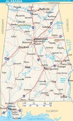
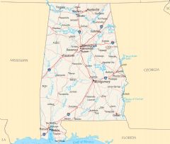
Alabama is located at 32°45'1"N 86°45'1"W (32.7504100, -86.7502600). It has 4 neighbors: Florida, Georgia, Mississippi and Tennessee.
Alabama map
The largest city of Alabama is Birmingham with a population of 206,950. Other cities include, Huntsville population 202,964, Montgomery population 196,268, Mobile population 187,746 and Tuscaloosa population 102,819. See all Alabama cities & populated places.
Largest Cities in Alabama (more)
Cities, Towns, Villages, Neighborhoods & Other Populated Places in Alabama.
| City Name | County | Population |
|---|---|---|
| Birmingham | Jefferson | 206,950 |
| Huntsville | Madison | 202,964 |
| Montgomery | Montgomery | 196,268 |
| Mobile | Mobile | 187,746 |
| Tuscaloosa | Tuscaloosa | 102,819 |
| Hoover | Jefferson | 85,959 |
| Dothan | Houston | 69,414 |
| Auburn | Lee | 68,343 |
| Decatur | Morgan | 54,381 |
| Madison | Madison | 52,654 |
| Florence | Lauderdale | 41,166 |
| Prattville | Autauga | 36,500 |
| Phenix City | Russell | 36,487 |
| East Florence | Lauderdale | 35,733 |
| Gadsden | Etowah | 34,816 |
| Vestavia Hills | Jefferson | 34,317 |
Show more Alabama cities and populated places
Official website of Alabama
Official Website- Jackson County
- Dale County
- Cherokee County
- Chambers County
- Coffee County
- Talladega County
- Marengo County
- Monroe County
- Etowah County
- Escambia County
- Sumter County
- Dallas County
- Macon County
- Conecuh County
- Cleburne County
- Lowndes County
- Randolph County
- Franklin County
- Hale County
- Colbert County
- Tuscaloosa County
- Russell County
- Greene County
- Geneva County
- Mobile County
- St. Clair County
- Pike County
- Henry County
- Crenshaw County
- Coosa County
- Clarke County
- Marion County
- Chilton County
- Madison County
- Covington County
- Wilcox County
- Clay County
- Lee County
- Blount County
- Shelby County
- Choctaw County
- Walker County
- Winston County
- Baldwin County
- Pickens County
- Limestone County
- Washington County
- Cullman County
- Jefferson County
- Lauderdale County
- Lawrence County
- Butler County
- Morgan County
- Lamar County
- Bibb County
- Fayette County
- Autauga County
- Montgomery County
- Barbour County
- Calhoun County
- Tallapoosa County
- Houston County
- Elmore County
- Bullock County
- DeKalb County
- Marshall County
- Perry County
Demographics
| Year | Population | % Change | Method |
|---|---|---|---|
| 1880 | 1,262,794 | - | |
| 1910 | 2,138,093 | 40.94% | census |
| 1920 | 2,348,174 | 8.95% | census |
| 1930 | 2,646,248 | 11.26% | census |
| 1940 | 2,832,961 | 6.59% | census |
| 1950 | 3,061,743 | 7.47% | census |
| 1960 | 3,266,740 | 6.28% | census |
| 1970 | 3,444,165 | 5.15% | census |
| 1980 | 3,893,888 | 11.55% | census |
| 1990 | 4,040,587 | 3.63% | census |
| 2000 | 4,447,100 | 9.14% | census |
| 2010 | 4,779,736 | 6.96% | census |
| 2011 | 4,799,069 | 0.4% | estimation process |
| 2012 | 4,815,588 | 0.34% | estimation process |
| 2013 | 4,830,081 | 0.3% | estimation process |
| 2014 | 4,841,799 | 0.24% | estimation process |
| 2015 | 4,852,347 | 0.22% | estimation process |
| 2016 | 4,863,525 | 0.23% | estimation process |
| 2017 | 4,874,486 | 0.22% | estimation process |
| 2018 | 4,887,681 | 0.27% | estimation process |
| 2019 | 4,903,185 | 0.32% | estimation process |
| 2020 | 4,921,532 | 0.37% | estimation process |
People born in Alabama (193)
People born in Alabama, including politician W. F. Turner, diplomat Ronald D. Johnson, photographer Michael Nichols, .
More notable people
- Hassani Gravett (American basketball player) he was born in 16/07/1996
- Mark Spencer (computer engineer) he was born in 08/04/1977
- Colonel Sanders (American entrepreneur and businessman) he was born in 09/09/1890
- Jimmy Swan (American singer) he was born in 18/11/1912
- Ma Rainey (African-American blues singer) she was born in 26/04/1886
- William McIntosh (Muscogee chief) he was born in 01/01/1775
- Opothleyahola (Muscogee Creek chief) he was born in 01/01/1798
- Linda Howard (American writer) she was born in 03/08/1950
- Avery Ardovino (American ski jumper) she was born in 13/02/1992
- Holland Smith (United States Marine Corps general) he was born in 20/04/1882
- Thomas Hinman Moorer (Chairman of the Joint Chiefs of Staff) he was born in 09/02/1912
- Billy Hitchcock (American baseball player, coach, manager, and scout (1916-2006)) he was born in 31/07/1916
- Pendleton Murrah (American politician (1826-1865)) he was born in 01/01/1826
- Coot Grant (American classic female blues and vaudeville singer and songwriter) she was born in 17/06/1893
- Curley Money (American rockabilly musician) he was born in 20/03/1925
- Ed Bell (American musician) he was born in 01/01/1905
- Heinie Manush (American baseball player and coach) he was born in 20/07/1901
- Hal Harris (American musician) he was born in 27/09/1920
Other places with the same name (1)
- Alabama, New York town in New York, United States with a population of 1,726 people.
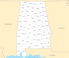
Alabama Counties (more)
Jefferson County

county in Alabama, United States
Mobile County

county in Alabama, United States
Madison County

county in Alabama, United States
| County Name | Population |
|---|---|
| Jefferson County | 655,342 |
| Mobile County | 412,716 |
| Madison County | 379,453 |
| Baldwin County | 229,287 |
| Montgomery County | 224,639 |
| Shelby County | 221,428 |
| Tuscaloosa County | 210,758 |
| Lee County | 166,831 |
| Morgan County | 119,883 |
| Calhoun County | 113,469 |
| Houston County | 106,580 |
| Etowah County | 102,371 |
| Limestone County | 102,228 |
| Marshall County | 96,990 |
| Lauderdale County | 93,368 |
| Saint Clair County | 90,739 |
Show more Alabama counties
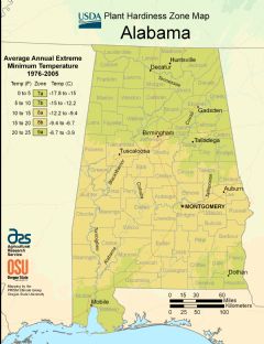
Map & Images (more maps)
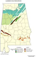
Alabama Coal Resources
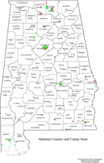
Alabama Counties
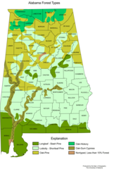
Alabama Forest Types
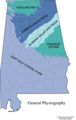
Alabama General Physiography
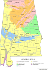
Alabama Map Soils
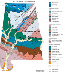
Alabama Physiographic Regions
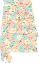
Alabama Road Map
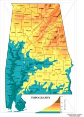
Alabama Topographic Map
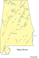
Albama Major Rivers Map
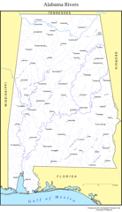
Albama Rivers Map
Map of Alabama Terrain Na
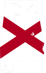
Alabama Flag Map
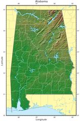
Alabama Relief Map
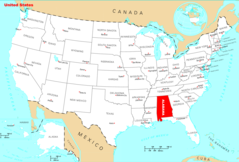
Where Is Alabama Located
Alabama Cities And Towns
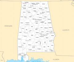
Alabama County Map
Alabama Reference Map
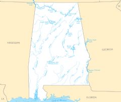
Alabama Rivers And Lakes