Baghdad, Baghdad
Baghdad: This historic city is located on the Tigris River, in the central part of Iraq.
About

Quick Facts about Baghdad
| Population | 6,960,000 |
| Country | Buyid dynasty, Ottoman Empire, Jalayirids, Abbasid Caliphate, Safavid Empire, Mandatory Iraq, Kingdom of Iraq, Ag Qoyunlu Tribe, Ilkhanate, Iraq, Kara Koyunlu tribe, Ottoman Empire, Safavid Empire, Sasanian Empire |
| State | Baghdad (Iraq) |
| County | Al Rusafa |
| Postal code | 10001–10090 |
| Area | 204.2 km2 |
| Official name | بغداد |
| Latitude & Longitude | 33.3406,44.4009 |
| Altitude | 112 feet / 34 meters |
| Capital city | Baghdad is capital of Kingdom of Iraq, Arab Federation, Ba'athist Iraq, Iraqi Republic (1958–68), Abbasid Caliphate, Buyid dynasty, Baghdad Governorate, Iraq, Baghdad Vilayet |
| Establishment | January 01, 0762 (1264 years ago) |
| Time Zone | UTC+03:00 |
| Local time | 00:15:22 (10th June 2026) |

%D9%81%D9%86%D8%AF%D9%82 %D8%A8%D8%BA%D8%AF%D8%A7%D8%AF %D8%B1%D9%88%D8%AA%D8%A7%D9%86%D8%A7 image
Geography
Baghdad is located at 33°20'26"N 44°24'3"E (33.3405800, 44.4008800).
Baghdad map
Click "full screen"  icon to open full mode. View satellite images
Official website of Baghdad
Official Website- Amman (1989 )
- Beirut
- Cairo
- Concord
- Damascus
- Dubai
- Jeddah
- Pavlodar
- Pyongyang
- Rabat
- Sana'a
- Tehran
Demographics
| Year | Population | % Change | Method |
|---|---|---|---|
| 2010 | 5,402,000 | - | census |
| 2015 | 9,028,000 | 40.16% | census |
| 2016 | 6,960,000 | -29.71% | census |
BGW, Bagda, Bagdad, Bagdadas, Bagdado, Bagdat, Bagdate, Bagdatum, Bagdod, Bagdá, Bagdád, Baghdād, Bağdad, Bağdat, Beghdad, Bexda, Lungsod ng Baghdad, ba ge da, bagadada, bageudadeu, bagudado, bghdad, bەghdad, paktat, Βαγδάτη, Багдад, Бағдод, Բաղդադ, בגדאד, بغداد, بەغداد, ܒܓܕܐܕ, बगदाद, বাগদাদ, பக்தாத், པ་ག་ཏ, ባግዳድ, バグダード, 巴格达, 바그다드
Map & Images (more maps)
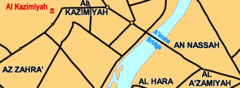
Al Aaimmah Bridge Area
665 x 243
- 10,549k -
png

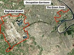
Baghdad Airport And Green Zone
496 x 371
- 58,810k -
jpg
Baghdad Airport And Green Zone
496 x 371
- 189,768k -
jpg
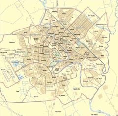
Map Of Baghdad Neighborhoods
2000 x 1967
- 620,917k -
PNG
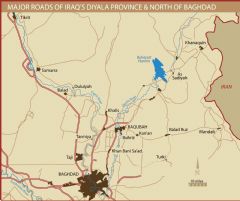
Northern Baghdad And Diyala Province Roads
2000 x 1679
- 198,281k -
PNG