Durand, Michigan
Durand: Human settlement in Shiawassee County, Michigan, United States of America
About
Durand is a city located in the county of Shiawassee in the U.S. state of Michigan. Its population at the 2010 census was 3,446 and a population density of 632 people per km². After 10 years in 2020 city had an estimated population of 3,269 inhabitants.

Quick Facts about Durand
| Population : | 3,269 (2020) |
| Country : | United States of America |
| State : | Michigan (United States) |
| County : | Shiawassee County |
| Postal code : | 48429 |
| Phone Area Codes : | 989 |
| Area : | 5.46 km2 |
| Altitude : | 794 feet / 242 meters |
| Time Zone : | Eastern Time Zone |
| Local time : | 15:23:52 (30th April 2025) |
| Density : | 599 Pop. per km² as of 2020 |
| Population growth : | -5.41% (2010-2020) |

Geography
Durand is located at 42°54'43"N 83°59'5"W (42.9119800, -83.9846800).
Durand map
- Official Website
Official website of Durand
Demographics
According to census records, the population of Durand decreased by 5.41% in 10 years.
| Year | Population | % Change | Method |
| 2010 | 3,446 | - | census |
| 2011 | 3,425 | -0.61% | estimation process |
| 2012 | 3,389 | -1.06% | estimation process |
| 2013 | 3,365 | -0.71% | estimation process |
| 2014 | 3,357 | -0.24% | estimation process |
| 2015 | 3,339 | -0.54% | estimation process |
| 2016 | 3,335 | -0.12% | estimation process |
| 2017 | 3,321 | -0.42% | estimation process |
| 2018 | 3,300 | -0.64% | estimation process |
| 2019 | 3,290 | -0.3% | estimation process |
| 2020 | 3,269 | -0.64% | estimation process |
Demographic Facts
| Estimated population as of July 1, 2019 : | 38,818 |
| Based on demographic estimates as of April 1, 2010 : | 39,135 |
| Based on demographic estimates as of 1 April 2010 : | -0.8% |
| April 1, 2020 Population : | 38,972 |
| April 1, 2010 Population : | 39,134 |
| People under 5 years old, percentage : | 6.0% |
| People under 18 years old, percentage : | 21.8% |
| People over 65 (%) : | 15.8% |
| Female persons, % : | 50.1% |
| White only, percent : | 91.4% |
| Black or African American alone, percent : | 2.4% |
| American Indian and Alaska Native only, % : | 1.2% |
| Asians alone % : | 1.9% |
| Only Native Hawaiians and Other Pacific Islanders, % : | 0.4% |
| % of people who have participated in two or more races : | 2.7% |
| % of Hispanic or Latino : | 6.1% |
| White people, not Hispanic or Latino people, make up the majority of the population. : | 86.0% |
| 2015-2019 Veterans : | 1,990 |
| Percentage of foreign-born people, 2015-2019 : | 3.6% |
| Residential units, July 1, 2019 : | 18,245 |
Economic Facts
| Residential units, July 1, 2019 : | 18,245 |
| Rate of owner-occupied housing units, 2015-2019 : | 59.4% |
| Owner-occupied housing unit median value, 2015-2019 : | $93,900 |
| From 2015 to 2019, the median selected monthly owner costs - with a mortgage : | $1,092 |
| Monthly owner costs, without a mortgage, at the median, 2015-2019 : | $440 |
| 2015-2019 median gross rent : | $717 |
| Permits for construction, 2020 : | 89 |
| 2015-2019 Households : | 15,284 |
| Population per household, 2015-2019 : | 2.42 |
| Living in the same house a year ago, percentage of people aged one year and up, 2015-2019 : | 78.2% |
| Languages other than English spoken at home, as a percentage of people aged 5 and up, 2015-2019 : | 5.8% |
| Households with computers, %, 2015-2019 : | 88.1% |
| Percentage of households with a broadband Internet subscription, 2015-2019 : | 77.0% |
| Percentage of people aged 25 and up with a high school diploma or higher, 2015-2019 : | 92.1% |
| Bachelor's degree or higher, proportion of people aged 25 and up, 2015-2019 : | 29.9% |
| Percentage of people under the age of 65 who have a disability, 2015-2019 : | 11.4% |
| Persons under the age of 65 who do not have health insurance, as a percentage : | 11.7% |
| Total civilian labor force, percent of population aged 16 and up, 2015-2019 : | 62.1% |
| Female labor force participation in the civilian labor force, as a percentage of the population aged 16 and up, 2015-2019 : | 59.5% |
| Total sales of lodging and food services in 2012 ($1,000) : | 59,173 |
| Total receipts/revenue for health care and social assistance in 2012 ($1,000) : | 233,781 |
| Manufacturers' total shipments in 2012 ($1,000) : | 823,365 |
| 2012 total retail sales ($1,000) : | 406,100 |
| 2012 total retail sales per capita : | $10,317 |
| Mean commute time to work (in minutes), workers aged 16 and up, 2015-2019 : | 16.9 |
| 2015-2019 median household income (in 2019 dollars) : | $41,004 |
| Income per capita in the previous 12 months (in 2019 dollars), 2015-2019 : | $23,091 |
| Percentage of people living in poverty : | 18.5% |
| Total number of employer establishments, 2019 : | 934 |
| 2019 total employment : | 14,352 |
| 2019 total annual payroll ($1,000) : | 487,347 |
| Total employment, change in percentage terms, 2018-2019 : | -1.9% |
| 2018 total non-employer establishments : | 2,100 |
| Total number of businesses in 2012 : | 2,515 |
| Men-owned businesses in 2012 : | 1,261 |
| Women-owned businesses in 2012 : | 771 |
| Minority-owned businesses in 2012 : | 122 |
| Non-minority-owned businesses in 2012 : | 2,168 |
| Veteran-owned businesses in 2012 : | 203 |
| Nonveteran-owned businesses in 2012 : | 2,084 |
| 2010 population per square mile : | 66.4 |
| 2010 land area in square miles : | 589.76 |
| Residential units, July 1, 2019 : | 10,306 |
| Rate of owner-occupied housing units, 2015-2019 : | 78.6% |
| Owner-occupied housing unit median value, 2015-2019 : | $183,900 |
| From 2015 to 2019, the median selected monthly owner costs - with a mortgage : | $1,459 |
| Monthly owner costs, without a mortgage, at the median, 2015-2019 : | $488 |
| 2015-2019 median gross rent : | $690 |
| Permits for construction, 2020 : | 76 |
| 2015-2019 Households : | 9,020 |
| Population per household, 2015-2019 : | 2.36 |
| Living in the same house a year ago, percentage of people aged one year and up, 2015-2019 : | 89.6% |
| Languages other than English spoken at home, as a percentage of people aged 5 and up, 2015-2019 : | 3.4% |
| Households with computers, %, 2015-2019 : | 88.1% |
| Percentage of households with a broadband Internet subscription, 2015-2019 : | 81.6% |
| Percentage of people aged 25 and up with a high school diploma or higher, 2015-2019 : | 93.4% |
| Bachelor's degree or higher, proportion of people aged 25 and up, 2015-2019 : | 23.7% |
| Percentage of people under the age of 65 who have a disability, 2015-2019 : | 7.8% |
| Persons under the age of 65 who do not have health insurance, as a percentage : | 6.2% |
| Total civilian labor force, percent of population aged 16 and up, 2015-2019 : | 67.0% |
| Female labor force participation in the civilian labor force, as a percentage of the population aged 16 and up, 2015-2019 : | 63.8% |
| Total sales of lodging and food services in 2012 ($1,000) : | 20,597 |
| Manufacturers' total shipments in 2012 ($1,000) : | 523,088 |
| 2012 total retail sales ($1,000) : | 223,854 |
| 2012 total retail sales per capita : | $10,423 |
| Mean commute time to work (in minutes), workers aged 16 and up, 2015-2019 : | 24.6 |
| 2015-2019 median household income (in 2019 dollars) : | $65,226 |
| Income per capita in the previous 12 months (in 2019 dollars), 2015-2019 : | $34,442 |
| Percentage of people living in poverty : | 8.4% |
| Total number of employer establishments, 2019 : | 555 |
| 2019 total employment : | 5,296 |
| 2019 total annual payroll ($1,000) : | 196,557 |
| Total employment, change in percentage terms, 2018-2019 : | -1.0% |
| 2018 total non-employer establishments : | 1,550 |
| Total number of businesses in 2012 : | 1,875 |
| Men-owned businesses in 2012 : | 1,067 |
| Women-owned businesses in 2012 : | 502 |
| Minority-owned businesses in 2012 : | 44 |
| Non-minority-owned businesses in 2012 : | 1,788 |
| Veteran-owned businesses in 2012 : | 152 |
| Nonveteran-owned businesses in 2012 : | 1,606 |
| 2010 population per square mile : | 41.4 |
| 2010 land area in square miles : | 522.98 |
Best Things to Do in Durand
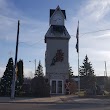
1 Durand Union Station Inc
200 S Railroad St, Durand, MI 48429, United States ➦ Show Map
☎ +19892883561 🔗 Url
2 Trumble Park
109 E Monroe Rd, Durand, MI 48429, United States ➦ Show Map
☎ +19892883113 🔗 Url
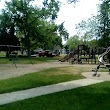
3 Optimist Park
102 E Fauble St, Durand, MI 48429, United States ➦ Show Map
☎ +19892883113 🔗 Url
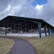
4 Durand Diamond Railroad Crossing
200 Grand Trunk Western Railroad, Durand, MI 48429, United States ➦ Show Map
☎ 🔗 Url
Other Places in Durand
1 Durand City Hall
215 W Clinton St, Durand, MI 48429 ➦ Show Map
☎ +19892883113 🔗 Url
Schools in Durand
College & universities near Durand, MI
| Code | Name | City | ZIP |
|---|---|---|---|
| 168847 | Baker College | Owosso (MI) | 48867 |
Stations (18)
Amtrak & bus stations near Durand, MI
| Code | Name | Address | Type |
|---|---|---|---|
| DRD | Durand Union Station | 200 South Railroad St. | RAIL |
| OWO | Owosso, MI | 109 Comstock Street | BUS |
| FLN | Flint station | 1407 South Dort Highway | RAIL |
| LNS | East Lansing station | 1240 South Harrison Road | RAIL |
| LPE | Lapeer station | 73 Howard St. | RAIL |
Other places with the same name (3)
- Durand , Illinois village in the United States with a population of 1,387 people.
- Durand , Wisconsin city in and county seat of Pepin County, Wisconsin with a population of 716 people.
Other cities in Shiawassee County
Cities, towns, neighborhoods & other populated places in Shiawassee County , MI.
| City Name | Population | Title |
|---|---|---|
| Owosso | 14,338 | City in Michigan, USA |
| Corunna | 3,320 | City in Michigan |
| Easton | 3,122 | Township in Shiawassee County, Michigan |
| Bennington | 3,048 | Township in Shiawassee County, Michigan |
| Perry | 2,075 | City in Shiawassee County in the U. |
| Laingsburg | 1,283 | City in Michigan, USA |
| Morrice | 906 | Settlement in Michigan |
| Vernon | 767 | Village in Michigan, United States |
| New Lothrop | 548 | Human settlement in Shiawassee County, Michigan, United States of America |
| Byron | 545 | Human settlement in Shiawassee County, Michigan, United States of America |
| Bancroft | 494 | Village in Michigan, United States |
| Lennon | 479 | Village in the United States, Michigan |
| Henderson | 168 | Township in Shiawassee County, Michigan |
Distance to Other Cities
Durand distances to largest Michigan cities