How far is Juneau, AK from Meadow Lakes, AK?
Distance by Flight
Shortest distance between Juneau and Meadow Lakes is 571.32 miles (919.45 km).
Flight distance from Juneau, AK to Meadow Lakes, AK is 571.32 miles. Estimated flight time is 01 hours 39 minutes.
It takes 01 hours 29 minutes to travel from Juneau to Meadow Lakes with an airplane (average speed of 550 miles).


Driving distance
The driving distance from Juneau, Alaska to Meadow Lakes, Alaska is: 823.5 miles (1325.3 km) by car.
Driving from Juneau to Meadow Lakes will take approximately 23 hours 51 minutes.

#1 Juneau
City in and state capital of Alaska, United States
| Population | 31974 |
|---|---|
| GPS Coordinates | 58°18'7"N 134°25'11"W |
| Latitude | 58.3019400 |
| Longitude | -134.4197200 |
| Altitude | 17 |
| Country | United States |

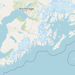
#2 Meadow Lakes
Census designated place in Alaska, United States
| Population | 7570 |
|---|---|
| GPS Coordinates | 61°37'29"N 149°36'4"W |
| Latitude | 61.6247200 |
| Longitude | -149.6011100 |
| Altitude | 116 |
| Country | United States |
Ending point in Meadow Lakes: Hess Lake Road (-149.598156,61.621245)
Estimated Travel Time Between Juneau and Meadow Lakes
The distance between Juneau and Meadow Lakes is 1325 km if you choose to drive by road. You can go 14 hours 43 minutes if you drive your car at an average speed of 90 kilometers / hour. For different choices, please review the avg. speed travel time table on the below.
There is no time difference between Juneau and Meadow Lakes. The current time is 01:15:26.
| Average Speed | Travel Time |
|---|---|
| 30 mph (48.3 km/h) | 27 hours 26 minutes |
| 40 mph (64.37 km/h) | 20 hours 35 minutes |
| 50 mph (80.47 km/h) | 16 hours 28 minutes |
| 60 mph (96.56 km/h) | 13 hours 43 minutes |
| 70 mph (112.65 km/h) | 11 hours 45 minutes |
| 75 mph (120.7 km/h) | 10 hours 58 minutes |
| 80 mph (128.75 km/h) | 10 hours 16 minutes |
Gas Consumption
A car with a fuel efficiency of 8.3 l/100 km will need 110 liters (29.06 gallon) of gas to cover the route between Juneau and Meadow Lakes.
The estimated cost of gas to go from Juneau to Meadow Lakes is $125.94 (diesel $134.14).
Alaska gas prices.
| Gasoline | Mid Grade | Premium | Diesel | |
|---|---|---|---|---|
| Gallon | $4.33 | $4.56 | $4.76 | $4.62 |
| Total | $125.94 | $132.57 | $138.44 | $134.14 |
Take a look at our Gas Cost Calculator feature. It will figure out how much it will cost to drive this particular distance.
The average gas price (in Alaska ) per gallon of daily gas for calculations is $4.334 (Diesel $4.616) /gallon. Last changed prices on June 30, 2025.
How did we calculate the distance?
The place names are translated into coordinates to approximate the distance between Juneau and Meadow Lakes (latitude and longitude). Cities, states, and countries each have their own regional center. The Haversine formula is used to measure the radius.
Distance to Other Cities


Driving distance from Gateway, AK to Juneau 815.91 miles (1313 km)


Driving distance from Sterling, AK to Juneau 984.84 miles (1585 km)

