Yerevan, Yerevan
Yerevan: This capital city is located along the Hrazdan River, in the western part of Armenia.
About

Quick Facts about Yerevan
| Population | 1,075,800 |
| Country | Russian Empire, First Republic of Armenia, Armenia, Soviet Union |
| State | Yerevan (Armenia) |
| Postal code | 0001–0099 |
| Phone Area Codes | 10 |
| Area | 227 km2 |
| Official name | Эривань, Ереван, Երևան |
| Latitude & Longitude | 40.1811,44.5136 |
| Legislative body | Yerevan City Council |
| Official language | Armenian |
| Altitude | 3,281 feet / 1000 meters |
| Capital city | Yerevan is capital of Erivansky Uyezd, First Republic of Armenia, Armenian oblast, Armenia, Sharur-Daralagozsky Uyezd, Erivan Governorate, Erivan Khanate, Russian Armenia |
| Establishment | January 01, -0781 (2807 years ago) |
| Time Zone | UTC+04:00 |
| Local time | 07:11:33 (10th June 2026) |

Yerevan coll mix image
Geography
Yerevan is located at 40°10'52"N 44°30'49"E (40.1811100, 44.5136100).
Yerevan map
Click "full screen"  icon to open full mode. View satellite images
Official website of Yerevan
Official Website- Amman (2014 )
- Antananarivo (1981 )
- Athens (1993 )
- Beirut (1997 )
- Bratislava (2001 )
- Buenos Aires (2000 )
- Cambridge (1987 )
- Carrara (1965 )
- Chișinău (2005 )
- Damascus (1997 )
- Delhi (2008 )
- Florence
- Isfahan (1995 )
- Kaliningrad (2009 )
- Khanty-Mansiysk (2014 )
- Kyiv (1995 )
- Los Angeles (2007 )
- Lyon (1993 )
- Marseille (1992 )
- Minsk (2002 )
- Montreal (1998 )
- Moscow (1995 )
- New Delhi
- Nice (2007 )
- Novosibirsk (2014 )
- Odessa (1995 )
- Podgorica (1974 )
- Riga (2013 )
- Rio de Janeiro (2007 )
- Rostov-on-Don
- Saint Petersburg (1997 )
- Shanghai (2009 )
- Sofia (2008 )
- Stavropol (2013 )
- São Paulo (2002 )
- Tallinn (2015 )
- Tbilisi (1996 )
- Venice (2011 )
- Volgograd (2015 )
- Nubarashen District
- Shengavit District
- Erebuni District
- Davtashen District
- Malatia-Sebastia District
- Nor Nork District
- Kentron District
- Avan District
- Ajapnyak District
- Kanaker-Zeytun District
- Nork-Marash District
- Arabkir District
Demographics
| Year | Population | % Change | Method |
|---|---|---|---|
| 2011 | 1,054,698 | - | census |
| 2016 | 1,074,000 | 1.8% | census |
| 2017 | 1,075,800 | 0.17% | census |
Ayrivan, Djerevan, EVN, Eireavan, Eireaván, Ereban, Erehvan, Ereun, Erevan, Erevan osh, Erevana, Erevano, Erevanum, Erevàn, Ereván, Erevāna, Erewan, Erivan, Eriwan, Erywan, Erywań, Gierevan, Ierevan, Iereván, Iravan, Jerevan, Jerevanas, Jerevani, Jereván, Jerewan, Jerjewan, Revan, Yervandavan, Yerêvan, Yiriwan, Yèrèvan, Yérévan, ayrwan, erevani, iyerebhana, shhr ayrwan, ye li wen, yeleban, yeravana pranta, yere wan, yerevana, yerevhana, yryfan, yrywan, Èrevan, Êrîvan, İrəvan, Γιερεβάν, Ερεβάν, Єреван, Јереван, Ереван, Ереван ош, Ерэван, Երեվան, Երևան, יערעוואן, ירוואן, ایروان, شهر ایروان, يريفان, يېرېۋان, یریوان, یەریڤان, येरवान प्रान्त, येरेवान, येरेव्हान, ইয়েরেভান, யெரெவான், เยเรวาน, ཡེ་རེ་ཝན།, ერევანი, ዬሬቫን, エレバン, 葉里溫, 예레반
Map & Images (more maps)
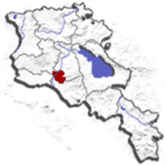
Armeniayerevan
150 x 148
- 8,875k -
png
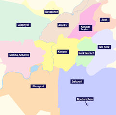
Districts Erevan
1420 x 1410
- 220,440k -
jpg
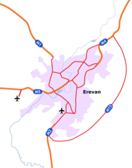
Reseau Routier Erevan
487 x 622
- 21,494k -
gif
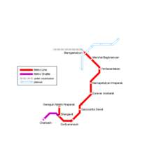
Yerevan Metro Map
1033 x 714
- 30,656k -
png

Yerevan Metro Map 1
650 x 650
- 4,048k -
png