West Virginia, US
West Virginia: Located in the Appalachian region of the Southern United States, this state is known for its mountains and rolling hills.
About
West Virginia is a state located in the Appalachian Mountain region of the Southern United States. It is bordered by Pennsylvania, Maryland, Virginia, Kentucky, and Ohio.
Some key facts about West Virginia:
- Capital: Charleston
- Population: Around 1.8 million
- Area: 24,230 square miles
- Nickname: The Mountain State
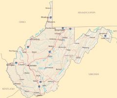
West Virginia's terrain is defined by the Appalachian Mountains, forests, rivers, and valleys. The state has countless mountain peaks and rolling hills. Major rivers include the Ohio River, Kanawha River, and Monongahela River. The mountainous topography lends to rugged, uneven land.
Coal mining has played a pivotal role in the state's history and development, along with timbering and chemical manufacturing. The economy today also relies on agriculture, biotech, and tourism based around outdoor recreation.
Cities like Charleston, Huntington, Morgantown, and Wheeling serve as economic and cultural hubs. West Virginia University and Marshall University are flagship educational institutions. The state struggles with poverty and the decline of coal mining jobs.
West Virginia is known for stunning natural beauty and outdoor activities like hiking, rafting, fishing, hunting, and skiing. Popular sites include Harpers Ferry, Seneca Rocks, and Blackwater Falls. The state has four distinct seasons.
In summary, West Virginia's winding mountains, mining heritage, and natural splendor make it a scenic state with rural charm despite underdevelopment and economic challenges. Its untouched mountain backdrop provides an escape into quintessential Appalachia.

State Snapshot
West Virginia at a glance
West Virginia currently has 265 quality-checked populated place pages and 55 county pages linked on MapSof.
Mapped cities & towns
265
These counts use a stricter populated-place filter so the main lists stay focused on real city and town pages.
County pages
55
Open related pagesLargest city
CharlestonPopulation 45,879
Top linked places
Quick Facts about West Virginia
| Population | 1,784,787 |
| Country | United States of America |
| Area | 62755 km2 |
| Water as percent of area | 0.79% |
| Land as percent of area | 99.21% |
| Latitude & Longitude | 38.5004,-80.5001 |
| Legislative body | West Virginia Legislature |
| Named for | west, Colony of Virginia |
| Altitude | 1,493 feet / 455 meters |
| Capital | Charleston |
| Establishment | June 20, 1863 (162 years ago) |
| Time Zone | America/New_York, Eastern Time Zone |
| Local time | 01:52:46 (10th June 2026) |
| Weather | 80℉ Showers And Thunderstorms Likely 7-days weather |

Geography
West Virginia is located at 38°30'1"N 80°30'0"W (38.5003800, -80.5000900). It has 5 neighbors: Maryland, Ohio, Kentucky, Pennsylvania and Virginia.
West Virginia map
The largest city of West Virginia is Charleston with a population of 45,879. Other cities include, Huntington population 44,934, Morgantown population 30,847, Parkersburg population 29,009 and Wheeling population 26,283. See all West Virginia cities & populated places.
Largest Cities in West Virginia (more)
Cities, Towns, Villages, Neighborhoods & Other Populated Places in West Virginia.
| City Name | County | Population |
|---|---|---|
| Charleston | Kanawha | 45,879 |
| Huntington | Cabell | 44,934 |
| Morgantown | Monongalia | 30,847 |
| Parkersburg | Wood | 29,009 |
| Wheeling | Ohio | 26,283 |
| Weirton Heights | Hancock | 19,450 |
| Fairmont | Marion | 18,370 |
| Weirton | Hancock | 18,068 |
| Martinsburg | Berkeley | 17,514 |
| Beckley | Raleigh | 15,805 |
| Clarksburg | Harrison | 15,424 |
| Teays Valley | Putnam | 13,175 |
| South Charleston | Kanawha | 12,036 |
| Vienna | Wood | 10,028 |
| Cross Lanes | Kanawha | 9,995 |
| Saint Albans | Kanawha | 9,763 |
Show more West Virginia cities and populated places
Weather
A chance of rain showers before 8am, then showers and thunderstorms likely. Mostly cloudy, with a high near 80. Chance of precipitation is 60%.
7-Day ForecastOfficial website of West Virginia
Official Website- Wayne County
- Ohio County
- Berkeley County
- Randolph County
- Kanawha County
- Fayette County
- Marshall County
- Pleasants County
- Cabell County
- Braxton County
- Wirt County
- Pocahontas County
- Clay County
- Webster County
- Calhoun County
- Monroe County
- Gilmer County
- Mercer County
- Brooke County
- Wyoming County
- Harrison County
- Pendleton County
- Tyler County
- Roane County
- Wood County
- Monongalia County
- Logan County
- Lincoln County
- Summers County
- Taylor County
- Upshur County
- Hardy County
- Tucker County
- Boone County
- Marion County
- Mineral County
- Jackson County
- Mingo County
- Preston County
- Morgan County
- Hancock County
- Ritchie County
- Putnam County
- Hampshire County
- Greenbrier County
- Raleigh County
- Doddridge County
- Nicholas County
- Lewis County
- McDowell County
- Mason County
- Wetzel County
- Jefferson County
- Grant County
- Barbour County
Demographics
| Year | Population | % Change | Method |
|---|---|---|---|
| 1910 | 1,221,119 | - | census |
| 1920 | 1,463,701 | 16.57% | census |
| 1930 | 1,729,205 | 15.35% | census |
| 1940 | 1,901,974 | 9.08% | census |
| 1950 | 2,005,552 | 5.16% | census |
| 1960 | 1,860,421 | -7.8% | census |
| 1970 | 1,744,237 | -6.66% | census |
| 1980 | 1,949,644 | 10.54% | census |
| 1990 | 1,793,477 | -8.71% | census |
| 2000 | 1,808,344 | 0.82% | census |
| 2010 | 1,852,994 | 2.41% | census |
| 2011 | 1,856,301 | 0.18% | estimation process |
| 2012 | 1,856,872 | 0.03% | estimation process |
| 2013 | 1,853,914 | -0.16% | estimation process |
| 2014 | 1,849,489 | -0.24% | estimation process |
| 2015 | 1,842,050 | -0.4% | estimation process |
| 2016 | 1,831,023 | -0.6% | estimation process |
| 2017 | 1,817,004 | -0.77% | estimation process |
| 2018 | 1,804,291 | -0.7% | estimation process |
| 2019 | 1,792,147 | -0.68% | estimation process |
| 2020 | 1,784,787 | -0.41% | estimation process |
People born in West Virginia (114)
People born in West Virginia, including racecar driver Duke Dinsmore, rock climber Royal Robbins, economist James Duesenberry, .
More notable people
- Gustavus Simmons (American cryptographer) he was born in 27/10/1930
- Jeanne Hines (American writer) she was born in 01/01/1922
- Wilber Pan (Taiwanese-American singer, actor and entrepreneur) he was born in 06/08/1980
- Frederick Mosteller (American statistician) he was born in 24/12/1916
- Jack Gregg (American musician) he was born in 01/01/1938
- Henry Swearingen (American politician (1792-1849)) he was born in 01/01/1792
- JT LeRoy (literary persona adopted by writer Laura Albert) he was born in 31/10/1980
- Janie Haddad Tompkins (American actress) she was born in 01/01/2000
- John Peale Bishop (American writer) he was born in 21/05/1892
- Wylie Draper (American actor (1969-1993)) he was born in 05/05/1969
- Leonard Barr (American actor and comedian (1903-1980)) he was born in 27/09/1903
- Fred Smith (American Musician) he was born in 13/09/1949
- Charlie Manuel (American baseball player and coach) he was born in 04/01/1944
- Dick Justice (American musician) he was born in 01/01/1906
- Frank Sampedro (American musician) he was born in 25/02/1949
- Henry W. Bigler he was born in 28/08/1815
- Richard Ellington (American writer and screenwriter) he was born in 21/05/1914
- Thomas Benjamin Fitzpatrick (Naval officer) he was born in 01/01/1896
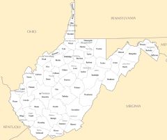
West Virginia Counties (more)
Kanawha County

county in West Virginia, United States
Berkeley County

county in West Virginia, United States of America
Monongalia County

county in West Virginia, United States
| County Name | Population |
|---|---|
| Kanawha County | 176,253 |
| Berkeley County | 122,125 |
| Monongalia County | 106,819 |
| Cabell County | 91,589 |
| Wood County | 82,938 |
| Raleigh County | 72,920 |
| Harrison County | 66,870 |
| Mercer County | 58,258 |
| Jefferson County | 57,486 |
| Putnam County | 56,428 |
| Marion County | 55,962 |
| Fayette County | 42,062 |
| Ohio County | 41,182 |
| Wayne County | 39,054 |
| Greenbrier County | 34,319 |
| Preston County | 33,380 |
Show more West Virginia counties
Map & Images (more maps)
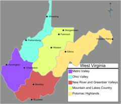
West Virginia Regions Map
Usa West Virginia Location Map
West Virginia Road Map
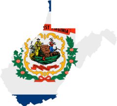
West Virginia Flag Map
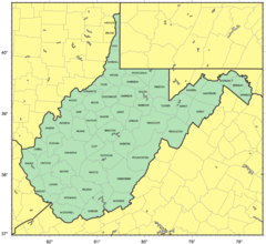
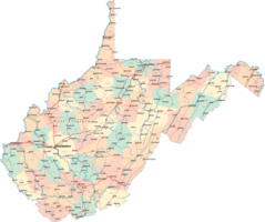
Counties Map of West Virginia
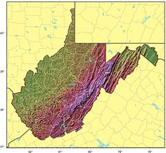
West Virginia Relief Map
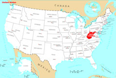
Where Is West Virginia Located
West Virginia Cities And Towns
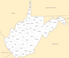
West Virginia County Map
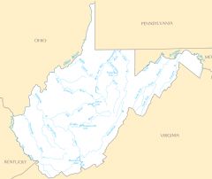
West Virginia Rivers And Lakes