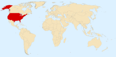
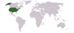
United States, US
United States: Located in North America, this country spans a vast area with diverse landscapes, from coastlines to mountain ranges.
About
The United States of America was founded on July 4, 1776 when the Declaration of Independence was signed. The original 13 colonies were located on the east coast and rebelled against British rule during the American Revolution. After the war ended in 1783, the US Constitution was ratified in 1788 and George Washington became the first president.
Some key events in early US history include:
- The Louisiana Purchase in 1803, which doubled the size of the country
- The War of 1812 against Britain
- Westward expansion across North America throughout the 1800s
- The Civil War from 1861-1865 between the Union and Confederate states over slavery
- The Industrial Revolution starting in the late 1800s
50 States
Today the United States consists of 50 states. The last states joined in 1959 when Alaska and Hawaii became states. The 5 most populous states are:
- California
- Texas
- Florida
- New York
- Pennsylvania
The US also has territories like Puerto Rico and Guam. Washington D.C. is the nation's capital.
Government
The US government has three branches:
- Executive - This includes the President, Vice President, and cabinet.
- Legislative - This is Congress, which contains the Senate and House of Representatives. Congress makes federal laws.
- Judicial - This is the Supreme Court and lower courts, which interpret laws.
The US Constitution is the foundation for the government. There are two main political parties: Democrats and Republicans.
Culture
American culture has significant influence worldwide. Some major aspects include films from Hollywood, music genres like jazz and rock and roll, and US brands like McDonald's, Coca-Cola, Nike and more. The US is ethnically diverse with influences from around the world.
Economy
The US has the world's largest economy with a GDP of over $20 trillion. Key industries include technology, financial services, healthcare, transportation, manufacturing, and agriculture. The US dollar is the dominant global currency. The economy is market-based and driven by consumer spending.

Country Snapshot
United States at a glance
United States currently has 26,934 quality-checked populated place pages and 51 state or regional pages linked on MapSof.
Mapped cities & towns
26,934
These counts use a stricter populated-place filter so the main lists stay focused on real city and town pages.
States & regions
51
Open related pagesLargest city
Los AngelesPopulation 3,970,219
Top linked places
Quick Facts about United States
| Population | 340,110,988 |
| Country | United States of America |
| Different from | Americas |
| Instagram username | usagov |
| Twitter username | usagov |
| Plate code | USA |
| Area | 9826675 km2 |
| Official name | the United States of America, Estados Unidos de América, Statele Unite ale Americii, Vereinigte Staaten von Amerika, Сједињене Америчке Државе, United States, États-Unis d’Amérique, Verenigde Staten van Amerika, Amerika Birleşik Devletleri, Stati Uniti d'America |
| Continent | North America, Oceania, Asia |
| Easternmost point | Point(-66.94995403 44.81539337) |
| Northernmost point | Point(-156.48 71.38) |
| Latitude & Longitude | 39.7600,-98.5000 |
| Legislative body | United States Congress, Congress of the Confederation |
| Named for | Americas |
| Official language | English, American English, Hawaiian, Spanish |
| Capital | Philadelphia, Washington, D.C., New York City |
| Time Zone | UTC+10:00, UTC−08:00, UTC−04:00, UTC−06:00, UTC−11:00, UTC+12:00, UTC−05:00, UTC−07:00, UTC−12:00, UTC−09:00, Alaska Time Zone, Chamorro Time Zone, Central Time Zone, Atlantic Time Zone, Mountain Time Zone, Samoa Time Zone |
| Local time | 14:50:21 (30th July 2026) |
| Weather | 90℉ Chance Showers And Thunderstorms 7-days weather |

Geography
United States is located at 39°45'36"N 98°30'0"W (39.7600000, -98.5000000). It has 14 neighbors: Japan, Russia, Micronesia, Dominican Republic, Cuba, Bahamas, Venezuela, Panama, Haiti, Mexico, Kiribati, Tonga, Samoa and Canada.
United States map
The largest city of United States is Los Angeles with a population of 3,970,219. Other cities include, Chicago population 2,677,643, Brooklyn population 2,577,000, Houston population 2,316,120 and Phoenix population 1,708,127. See all United States cities & populated places.
Weather
A chance of showers and thunderstorms before 7am, then a chance of showers and thunderstorms between 7am and 1pm, then a slight chance of showers and...
7-Day ForecastCompare United States with
- Southwest Territory
- Mississippi
- Michigan
- Missouri
- Louisiana Territory
- Maryland
- Vermont
- Northwest Territory
- New Mexico
- Arizona
- Idaho
- Montana
- Territory of Hawaii
- Nevada
- Territory of Orleans
- Nebraska
- Minnesota
- Mississippi Territory
- Indiana Territory
- Texas
- Michigan Territory
- Hawaii
- Pennsylvania
- Territory of Alaska
- Wyoming
- South Dakota
- New Hampshire
- Illinois
- Puerto Rico
- Oregon
- South Carolina
- Indiana
- Ohio
- Washington
- Utah
- Arkansas
- North Dakota
- Colorado
- United States Virgin Islands
- Alaska
- Tennessee
- Florida
- Maine
- Iowa
- Massachusetts
- Kentucky
- Louisiana
- Oklahoma
- Commonwealth of the Philippines
- Georgia
- Rhode Island
- Insular Government of the Philippine Islands
- New Jersey
- North Carolina
- Washington, D.C.
- Wisconsin
- Delaware
- New York
- Alabama
- Connecticut
- Virginia
- West Virginia
- California
- Kansas
- District of Columbia
- Guam
- United States Minor Outlying Islands
- Northern Mariana Islands
- American Samoa
Demographics
| Year | Population | % Change | Method |
|---|---|---|---|
| 1790 | 3,929,214 | - | estimation process |
| 1800 | 5,308,483 | 25.98% | estimation process |
| 1810 | 7,239,881 | 26.68% | estimation process |
| 1820 | 9,638,453 | 24.89% | estimation process |
| 1830 | 12,866,020 | 25.09% | estimation process |
| 1840 | 17,069,458 | 24.63% | estimation process |
| 1850 | 23,191,876 | 26.4% | estimation process |
| 1860 | 31,443,321 | 26.24% | estimation process |
| 1870 | 39,818,449 | 21.03% | estimation process |
| 1880 | 50,189,209 | 20.66% | estimation process |
| 1890 | 62,979,766 | 20.31% | estimation process |
| 1900 | 76,212,168 | 17.36% | estimation process |
| 1901 | 77,584,000 | 1.77% | estimation process |
| 1902 | 79,163,000 | 1.99% | estimation process |
| 1903 | 80,632,000 | 1.82% | estimation process |
| 1904 | 82,166,000 | 1.87% | estimation process |
| 1905 | 83,822,000 | 1.98% | 158301100 |
| 1906 | 85,450,000 | 1.91% | estimation process |
| 1907 | 87,008,000 | 1.79% | estimation process |
| 1908 | 88,710,000 | 1.92% | estimation process |
| 1909 | 90,490,000 | 1.97% | estimation process |
| 1910 | 92,407,000 | 2.07% | estimation process |
| 1911 | 93,863,000 | 1.55% | estimation process |
| 1912 | 95,335,000 | 1.54% | estimation process |
| 1913 | 97,225,000 | 1.94% | estimation process |
| 1914 | 99,111,000 | 1.9% | estimation process |
| 1915 | 100,546,000 | 1.43% | estimation process |
| 1916 | 101,961,000 | 1.39% | estimation process |
| 1917 | 103,268,000 | 1.27% | estimation process |
| 1918 | 103,208,000 | -0.06% | estimation process |
| 1919 | 104,514,000 | 1.25% | estimation process |
| 1920 | 105,710,620 | 1.13% | estimation process |
| 1930 | 122,775,046 | 13.9% | estimation process |
| 1940 | 132,164,569 | 7.1% | estimation process |
| 1950 | 150,697,361 | 12.3% | estimation process |
| 1960 | 179,323,175 | 15.96% | estimation process |
| 1961 | 183,691,000 | 2.38% | (Worldbank) |
| 1962 | 186,538,000 | 1.53% | (Worldbank) |
| 1963 | 189,242,000 | 1.43% | (Worldbank) |
| 1964 | 191,889,000 | 1.38% | (Worldbank) |
| 1965 | 194,303,000 | 1.24% | (Worldbank) |
| 1966 | 196,560,000 | 1.15% | (Worldbank) |
| 1967 | 198,712,000 | 1.08% | (Worldbank) |
| 1968 | 200,706,000 | 0.99% | (Worldbank) |
| 1969 | 202,677,000 | 0.97% | (Worldbank) |
| 1970 | 203,302,031 | 0.31% | estimation process |
| 1971 | 207,661,000 | 2.1% | (Worldbank) |
| 1972 | 209,896,000 | 1.06% | (Worldbank) |
| 1973 | 211,909,000 | 0.95% | (Worldbank) |
| 1974 | 213,854,000 | 0.91% | (Worldbank) |
| 1975 | 215,973,000 | 0.98% | (Worldbank) |
| 1976 | 218,035,000 | 0.95% | (Worldbank) |
| 1977 | 220,239,000 | 1% | (Worldbank) |
| 1978 | 222,585,000 | 1.05% | (Worldbank) |
| 1979 | 225,055,000 | 1.1% | (Worldbank) |
| 1980 | 226,545,805 | 0.66% | estimation process |
| 1981 | 229,466,000 | 1.27% | (Worldbank) |
| 1982 | 231,664,000 | 0.95% | (Worldbank) |
| 1983 | 233,792,000 | 0.91% | (Worldbank) |
| 1984 | 235,825,000 | 0.86% | (Worldbank) |
| 1985 | 237,924,000 | 0.88% | (Worldbank) |
| 1986 | 240,133,000 | 0.92% | (Worldbank) |
| 1987 | 242,289,000 | 0.89% | (Worldbank) |
| 1988 | 244,499,000 | 0.9% | (Worldbank) |
| 1989 | 246,819,000 | 0.94% | (Worldbank) |
| 1990 | 248,709,873 | 0.76% | estimation process |
| 1991 | 252,981,000 | 1.69% | (Worldbank) |
| 1992 | 256,514,000 | 1.38% | (Worldbank) |
| 1993 | 259,919,000 | 1.31% | (Worldbank) |
| 1994 | 263,126,000 | 1.22% | (Worldbank) |
| 1995 | 266,278,000 | 1.18% | (Worldbank) |
| 1996 | 269,394,000 | 1.16% | (Worldbank) |
| 1997 | 272,657,000 | 1.2% | (Worldbank) |
| 1998 | 275,854,000 | 1.16% | (Worldbank) |
| 1999 | 279,040,000 | 1.14% | (Worldbank) |
| 2000 | 281,421,906 | 0.85% | estimation process |
| 2001 | 284,968,955 | 1.24% | (Worldbank) |
| 2002 | 287,625,193 | 0.92% | (Worldbank) |
| 2003 | 290,107,933 | 0.86% | (Worldbank) |
| 2004 | 292,805,298 | 0.92% | (Worldbank) |
| 2005 | 295,516,599 | 0.92% | (Worldbank) |
| 2006 | 298,379,912 | 0.96% | (Worldbank) |
| 2007 | 301,231,207 | 0.95% | (Worldbank) |
| 2008 | 304,093,966 | 0.94% | (Worldbank) |
| 2009 | 306,771,529 | 0.87% | (Worldbank) |
| 2010 | 308,745,538 | 0.64% | estimation process |
| 2011 | 311,556,874 | 0.9% | (Worldbank) |
| 2012 | 313,830,990 | 0.72% | (Worldbank) |
| 2013 | 316,128,839 | 0.73% | estimation process |
| 2014 | 318,301,008 | 0.68% | (Worldbank) |
| 2015 | 320,635,163 | 0.73% | (Worldbank) |
| 2016 | 323,952,889 | 1.02% | estimation process |
| 2017 | 325,145,963 | 0.37% | estimation process |
| 2018 | 326,687,501 | 0.47% | (Worldbank) |
| 2019 | 328,239,523 | 0.47% | estimation process |
| 2020 | 331,449,281 | 0.97% | census |
| 2026 | 340,110,988 | 2.55% |
People born in United States (200)
People born in United States, including actress Molly Sims, US writer Amy Lowell, film director, producer and screenwriter Kim Henkel, .
More notable people
- Bryan Konietzko (American animation director) he was born in 26/05/1976
- Jon Hall (programmer and major contributor to the Linux project) he was born in 07/08/1950
- Douglas McIlroy (American computer scientist, mathematician, engineer, and programmer) he was born in 01/01/1932
- Gerald Jay Sussman (American computer scientist) he was born in 08/02/1947
- Monte Davidoff (American computer programmer) he was born in 01/01/1956
- Scott Meyers (American computer programmer) he was born in 09/04/1959
- Michael Laughlin (American film director, producer and screenwriter) he was born in 01/01/1938
- Stephen Trask (American composer) was born in 29/08/1966
- Mike Grell (Comic book artist and writer) he was born in 13/09/1947
- Jimmy Lee Gray (American murderer) he was born in 25/09/1949
- Daniel Lewis Williams (American operatic bass) he was born in 01/01/1950
- David P. Bartel (American biochemist) he was born in 01/01/2000
- Alfred Hubler (American physicist) he was born in 16/05/1957
- Dennis Jenkins (research archaeologist) he was born in 01/01/2000
- Dwayne A. Day (American space historian) he was born in 01/01/2000
- Frankie Masters (big band leader) he was born in 12/04/1904
- Earl Mac Rauch (writer and screenwriter) he was born in 01/01/1949
- Zach Staenberg (American film editor) he was born in 01/08/1951
United States States
| State Name | Population | Title |
|---|---|---|
| Alabama | 4,921,532 | One of the 50 states that make up the United States of America is Alabama. |
| Alaska | 731,545 | One of fifty states that make up the United States of America. |
| Arizona | 7,421,401 | Located in the southwestern United States, this state is known for its desert landscape and the Grand Canyon. |
| Arkansas | 0 | Located in the southeastern region of the United States, this state is known for its diverse landscapes, including the Ozark Mountains and the Mississippi River Delta. |
| California | 39,368,078 | Located on the West Coast of the United States, this state is known for its diverse geography, including beaches, mountains, and deserts. |
| Colorado | 5,807,719 | Located in the western United States, Colorado is known for its diverse landscape of mountains, forests, high plains, and desert lands. |
| Connecticut | 3,557,006 | Located in the New England region of the northeastern United States, this state is home to cities such as Hartford, its capital, and New Haven. |
| Delaware | 986,809 | This Mid-Atlantic U. |
| District of Columbia | 712,816 | The District of Columbia, a federal district, is located on the Potomac River, bordering Maryland and Virginia. |
| Florida | 21,733,312 | Located in the southeastern United States, this peninsula is bordered by the Atlantic Ocean to the east and the Gulf of Mexico to the west. |
| Georgia | 4,000,921 | Located in the southeastern United States, this state is known for its diverse geography, spanning from the Appalachian Mountains to the Atlantic coast. |
| Hawaii | 1,407,006 | This U. |
| Idaho | 1,787,065 | This northwestern U. |
| Illinois | 12,587,530 | Located in the Midwest, it is home to Chicago, the third-largest city in the US. |
| Indiana | 6,754,953 | Located in the Midwest, Indiana is known for its diverse economy, including manufacturing and agriculture. |
| Iowa | 3,163,561 | Located in the Midwestern United States, this state is known for its fertile farmlands and significant role in agriculture. |
| Kansas | 2,913,805 | This Midwestern U. |
| Kentucky | 4,477,251 | Located in the Upland South of the United States, this state is bordered by the Ohio River to the north. |
| Louisiana | 4,645,318 | Located in the southeastern United States, Louisiana is known for its unique Creole and Cajun cultures, vibrant music scene, and diverse ecosystems. |
| Maine | 1,350,141 | Located in the northeastern United States, Maine is known for its rocky coastline, maritime history, and extensive forests. |
| Maryland | 6,055,802 | Located in the Mid-Atlantic region, this state is home to the capital city of Annapolis and the largest city of Baltimore. |
| Massachusetts | 6,893,574 | Located in the New England region of the northeastern United States, Massachusetts is home to major cities like Boston and Worcester. |
| Michigan | 9,966,555 | Located in the Great Lakes region of the Midwestern United States, this state is recognized for its two peninsulas separated by the Straits of Mackinac. |
| Minnesota | 5,657,342 | Located in the upper Midwest region of the United States, this state is home to the major cities of Minneapolis and Saint Paul. |
| Mississippi | 2,966,786 | Located in the southeastern United States, Mississippi is known for its rich musical heritage, particularly blues music, and its significant role in the American Civil Rights Movement. |
| Missouri | 6,151,548 | Located in the Midwestern United States, Missouri is known as the "Show Me State. |
| Montana | 1,080,577 | Located in the Western United States, it is bordered by Canada to the north and Idaho, Wyoming, and the Dakotas to the west, south, and east. |
| Nebraska | 1,937,552 | State of the United States of America. |
| Nevada | 3,138,259 | Located in the Western United States, it is characterized by its largely desert and semi-arid climate. |
| New Hampshire | 1,366,275 | Located in the New England region of the northeastern United States, this state is known for its expansive forests, mountains, and picturesque coastline. |
| New Jersey | 8,882,371 | Located in the Mid-Atlantic region of the United States, this state is home to major cities like Newark, Jersey City, and the state capital, Trenton. |
| New Mexico | 2,106,319 | This southwestern U. |
| New York | 19,336,776 | Located in the northeastern United States, it is home to New York City, Albany, and Buffalo. |
| North Carolina | 10,600,823 | Located on the East Coast of the United States, this state is home to major cities like Charlotte, Raleigh, and Greensboro. |
| North Dakota | 765,309 | Located in the Upper Midwest region of the United States, this state is known for its vast plains, Badlands in the west, and agricultural industry. |
| Ohio | 11,693,217 | Located in the Midwest region of the United States, this state is home to major cities like Columbus, Cleveland, and Cincinnati. |
| Oklahoma | 3,980,783 | Located in the South Central region of the United States, this state is known for its diverse geography, including plains, mountains, and forests. |
| Oregon | 4,241,507 | Located in the Pacific Northwest region, Oregon is known for its diverse landscapes, including the Pacific coastline, the Cascade Mountains, and high desert. |
| Pennsylvania | 12,783,254 | This Mid-Atlantic state is bordered by six other states and features a diverse landscape, from the Appalachian Mountains to the fertile farmlands. |
| Rhode Island | 1,057,125 | Located in the New England region of the northeastern United States, this state is home to the capital city of Providence and other key areas like Warwick. |
| South Carolina | 5,218,040 | Located in the southeastern United States, this state is known for its diverse landscapes, from Appalachian mountains to Atlantic beaches. |
| South Dakota | 892,717 | Located in the Upper Midwest region of the United States, this state is known for its prairies, badlands, and the Black Hills, home to Mount Rushmore. |
| Tennessee | 6,886,834 | Located in the southeastern United States, this state is known for its diverse music heritage, including country, blues, and rock and roll. |
| Texas | 29,360,759 | This southern US state shares a border with Mexico, and its major cities include Houston, San Antonio, Dallas, and the capital, Austin. |
| Utah | 3,249,879 | Located in the western United States, Utah is known for its diverse natural landscapes, including the Rocky Mountains and the Great Salt Lake. |
| Vermont | 623,347 | Located in the New England region of the northeastern United States, this state is known for its natural landscapes, including the Green Mountains. |
| Virginia | 8,590,563 | Located in the Mid-Atlantic region of the United States, this state is home to key cities like Richmond (the capital), Virginia Beach, and Norfolk. |
| Washington | 7,693,612 | Located in the Pacific Northwest region of the United States, Washington is known for its diverse landscapes, including the Olympic Mountains and the Columbia River. |
| West Virginia | 1,784,787 | Located in the Appalachian region of the Southern United States, this state is known for its mountains and rolling hills. |
| Wisconsin | 5,832,655 | Located in the upper Midwest of the United States, this state is bordered by Lake Michigan to the east and Lake Superior to the north. |
| Wyoming | 582,328 | This western U. |
Map & Images (more maps)
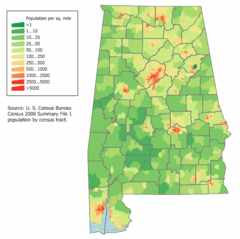
Alabama Population Map
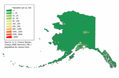
Alaska Population Map
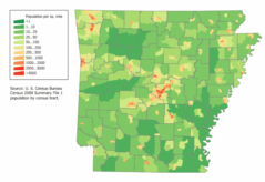
Arkansas Population Map
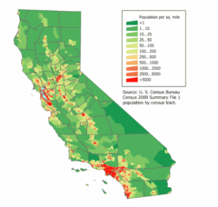
California Population Map
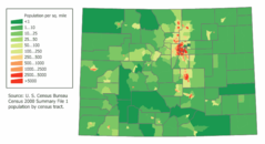
Colorado Population Map
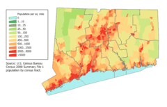
Connecticut Population Map
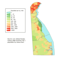
Delaware Population Map
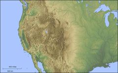
Der Westen Der Vereinigten Staaten
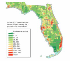
Florida Population Map
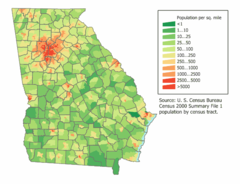
Georgia Population Map
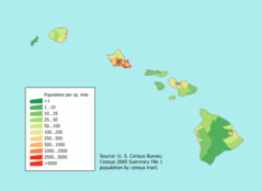
Hawaii Population Map
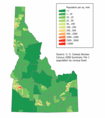
Idaho Population Map
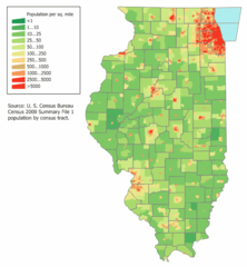
Illinois Population Map
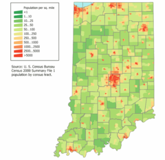
Indiana Population Map
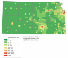
Kansas Population Map
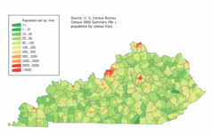
Kentucky Population Map
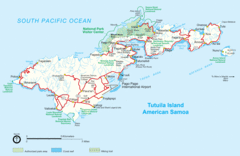
Location Uf Us
Location Usa
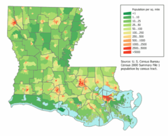
Louisiana Population Map
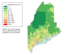
Maine Population Map