Turkmenistan, TM
Turkmenistan: Located in Central Asia, it is known for its vast Karakum Desert, rich natural gas reserves, and distinctive culture.
About

Country Snapshot
Turkmenistan at a glance
Turkmenistan currently has 20 quality-checked populated place pages and 6 state or regional pages linked on MapSof.
Mapped cities & towns
20
These counts use a stricter populated-place filter so the main lists stay focused on real city and town pages.
States & regions
6
Open related pagesLargest city
AshgabatPopulation 828,100
Top linked places
Quick Facts about Turkmenistan
| Population | 7,057,841 |
| Country | Turkmenistan |
| Different from | Turkestan |
| Plate code | TM |
| Area | 491210 km2 |
| Official name | le Turkménistan, Türkmenistan |
| Continent | Asia |
| Northernmost point | Point(58.63 42.78) |
| Latitude & Longitude | 39.7500,59.6667 |
| Legislative body | Assembly of Turkmenistan |
| Official language | Turkmen |
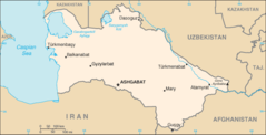
| Capital | Ashgabat |
| Establishment | October 27, 1991 (34 years ago) |
| Time Zone | UTC+05:00 |
| Local time | 12:38:45 (10th June 2026) |

Geography
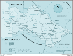
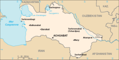
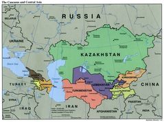
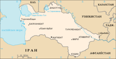
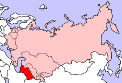
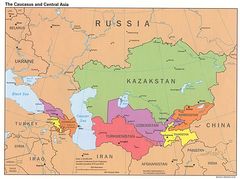
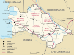
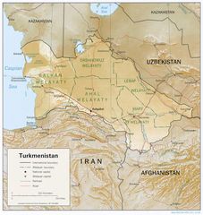
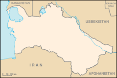
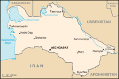
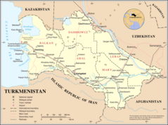
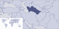
Turkmenistan is located at 39°45'0"N 59°40'0"E (39.7500000, 59.6666700). It has 4 neighbors: Iran, Afghanistan, Uzbekistan and Kazakhstan.
Turkmenistan map
The largest city of Turkmenistan is Ashgabat with a population of 828,100. Other cities include, Türkmenabat population 408,906, Türkmenbaşy population 70,962 and Atamyrat population 39,602. See all Turkmenistan cities & populated places.
Compare Turkmenistan with
- Daşoguz Region
- Ashgabat
- Mary Region
- Balkan Region
- Lebap Region
- Ahal Region
Demographics
| Year | Population | % Change | Method |
|---|---|---|---|
| 1960 | 1,603,258 | - | (Worldbank) |
| 1961 | 1,658,362 | 3.32% | (Worldbank) |
| 1962 | 1,715,408 | 3.33% | (Worldbank) |
| 1963 | 1,773,853 | 3.29% | (Worldbank) |
| 1964 | 1,833,064 | 3.23% | (Worldbank) |
| 1965 | 1,892,599 | 3.15% | (Worldbank) |
| 1966 | 1,952,141 | 3.05% | (Worldbank) |
| 1967 | 2,011,764 | 2.96% | (Worldbank) |
| 1968 | 2,071,790 | 2.9% | (Worldbank) |
| 1969 | 2,132,802 | 2.86% | (Worldbank) |
| 1970 | 2,195,175 | 2.84% | (Worldbank) |
| 1971 | 2,258,965 | 2.82% | (Worldbank) |
| 1972 | 2,324,015 | 2.8% | (Worldbank) |
| 1973 | 2,390,216 | 2.77% | (Worldbank) |
| 1974 | 2,457,384 | 2.73% | (Worldbank) |
| 1975 | 2,525,364 | 2.69% | (Worldbank) |
| 1976 | 2,594,313 | 2.66% | (Worldbank) |
| 1977 | 2,664,258 | 2.63% | (Worldbank) |
| 1978 | 2,734,895 | 2.58% | (Worldbank) |
| 1979 | 2,805,819 | 2.53% | (Worldbank) |
| 1980 | 2,876,808 | 2.47% | (Worldbank) |
| 1981 | 2,947,779 | 2.41% | (Worldbank) |
| 1982 | 3,019,066 | 2.36% | (Worldbank) |
| 1983 | 3,091,513 | 2.34% | (Worldbank) |
| 1984 | 3,166,221 | 2.36% | (Worldbank) |
| 1985 | 3,244,018 | 2.4% | (Worldbank) |
| 1986 | 3,324,458 | 2.42% | (Worldbank) |
| 1987 | 3,407,321 | 2.43% | (Worldbank) |
| 1988 | 3,493,895 | 2.48% | (Worldbank) |
| 1989 | 3,585,868 | 2.56% | (Worldbank) |
| 1990 | 3,683,967 | 2.66% | (Worldbank) |
| 1991 | 3,789,185 | 2.78% | (Worldbank) |
| 1992 | 3,899,843 | 2.84% | (Worldbank) |
| 1993 | 4,010,789 | 2.77% | (Worldbank) |
| 1994 | 4,115,102 | 2.53% | (Worldbank) |
| 1995 | 4,207,841 | 2.2% | (Worldbank) |
| 1996 | 4,287,346 | 1.85% | (Worldbank) |
| 1997 | 4,355,116 | 1.56% | (Worldbank) |
| 1998 | 4,413,479 | 1.32% | (Worldbank) |
| 1999 | 4,466,135 | 1.18% | (Worldbank) |
| 2000 | 4,516,133 | 1.11% | (Worldbank) |
| 2001 | 4,564,083 | 1.05% | (Worldbank) |
| 2002 | 4,610,005 | 1% | (Worldbank) |
| 2003 | 4,655,743 | 0.98% | (Worldbank) |
| 2004 | 4,703,401 | 1.01% | (Worldbank) |
| 2005 | 4,754,646 | 1.08% | (Worldbank) |
| 2006 | 4,810,109 | 1.15% | (Worldbank) |
| 2007 | 4,870,141 | 1.23% | (Worldbank) |
| 2008 | 4,935,767 | 1.33% | (Worldbank) |
| 2009 | 5,007,954 | 1.44% | (Worldbank) |
| 2010 | 5,087,213 | 1.56% | (Worldbank) |
| 2011 | 5,174,085 | 1.68% | (Worldbank) |
| 2012 | 5,267,900 | 1.78% | (Worldbank) |
| 2013 | 5,366,375 | 1.84% | (Worldbank) |
| 2014 | 5,466,328 | 1.83% | (Worldbank) |
| 2015 | 5,565,287 | 1.78% | (Worldbank) |
| 2016 | 5,662,372 | 1.71% | (Worldbank) |
| 2017 | 5,757,669 | 1.66% | (Worldbank) |
| 2018 | 5,850,901 | 1.59% | estimation process |
| 2019 | 5,942,089 | 1.53% | (Worldbank) |
| 2026 | 7,057,841 | 15.81% |
Map & Images (more maps)
Carte Turkmenistan Fr
Caucasus Central Asia Political Map 2000 6
Central Asia 1900 2
Map of Turkmenistan Uk
Sovietunionturkmenistan
The Caucasus And Central Asia Political Map 5
Turkestan 1900 Es 2
Turkmenija
Turkmenistan 1994 Cia Map
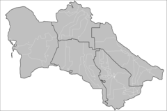
Turkmenistan Districts
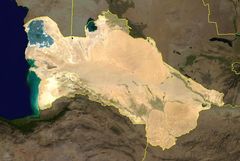
Turkmenistan Satellite Photo
Turkmenistan Stub
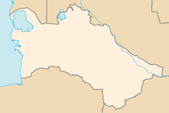
Turkmenistan Locator
Turkmenistan Map Blank
Turkmenistan Map
Tx Map German
Un Turkmenistan
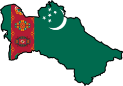
Turkmenistan Flag Map
Where Is Turkmenistan Located