Turkey (Republic of Turkey), TR
Turkey: Straddling Western Asia and Southeast Europe, this transcontinental country serves as a bridge between cultures.
About

Country Snapshot
Republic of Turkey at a glance
Republic of Turkey currently has 629 quality-checked populated place pages and 81 state or regional pages linked on MapSof.
Mapped cities & towns
629
These counts use a stricter populated-place filter so the main lists stay focused on real city and town pages.
States & regions
81
Open related pagesLargest city
IstanbulPopulation 15,067,724
Top linked places
Quick Facts about Republic of Turkey
| Population | 85,664,944 |
| Country | Turkey |
| Different from | Turkestan |
| Instagram username | edevletkapisi |
| Twitter username | ekapi |
| Plate code | TR |
| Area | 783562.05 km2 |
| Official name | la République de Turquie, Türkiye Cumhuriyeti |
| Continent | Europe, Asia |
| Easternmost point | Point(44.817 39.65325) |
| Northernmost point | Point(27.240166666 42.104722222) |
| Latitude & Longitude | 39.0000,35.0000 |
| Legislative body | Grand National Assembly of Turkey |
| Official language | Turkish |
| Capital | Ankara |
| Establishment | October 29, 1923 (102 years ago) |
| Time Zone | UTC+03:00 |
| Local time | 04:56:05 (28th July 2026) |

Geography
Republic of Turkey is located at 39°0'0"N 35°0'0"E (39.0000000, 35.0000000). It has 12 neighbors: Iraq, Iran, Cyprus, Naxcivan Muxtar Respublikasi, Syria, Armenia, Greece, Azerbaijan, Georgia, Ukraine, Bulgaria and Union.
Turkey map
The largest city of Republic of Turkey is Istanbul with a population of 15,067,724. Other cities include, Ankara population 5,503,985, Bursa population 2,994,521, İzmir population 2,500,603 and Konya population 2,232,374. See all Republic of Turkey cities & populated places.
Compare Republic of Turkey with
- Trabzon Province
- Diyarbakır Province
- Niğde Province
- Bolu Province
- Isparta Province
- Aydın Province
- Tunceli Province
- Yozgat Province
- Kırıkkale Province
- Kütahya Province
- Erzincan Province
- Hakkâri Province
- Edirne Province
- Kırşehir Province
- Ağrı Province
- Bilecik Province
- Bingöl Province
- Manisa Province
- Zonguldak Province
- Şanlıurfa Province
- Kahramanmaraş Province
- Gümüşhane Province
- Kayseri Province
- Çankırı Province
- Giresun Province
- Bitlis Province
- Bartın Province
- Uşak Province
- Karabük Province
- Kastamonu Province
- Eskişehir Province
- Sakarya Province
- Şırnak Province
- Kilis Province
- Muğla Province
- Afyonkarahisar Province
- Bursa Province
- Malatya Province
- Denizli Province
- Tekirdağ Province
- Kırklareli Province
- Bayburt Province
- Amasya Province
- Düzce Province
- Burdur Province
- Yalova Province
- Artvin Province
- Samsun Province
- Ordu Province
- Antalya Province
- Ardahan Province
- Rize Province
- Sinop Province
- Adıyaman Province
- Elazığ Province
- Konya Province
- Istanbul Province
- Çorum Province
- Batman Province
- Van Province
- Tokat Province
- Mardin Province
- Siirt Province
- Nevşehir Province
- İzmir Province
- Gaziantep Province
- Erzurum Province
- Aksaray Province
- Adana Province
- Osmaniye Province
- Iğdır Province
- Sivas Province
- Muş Province
- Karaman Province
- Çanakkale Province
- Mersin Province
- Hatay Province
- Kocaeli Province
- Ankara Province
- Kars Province
- Balıkesir Province
Demographics
| Year | Population | % Change | Method |
|---|---|---|---|
| 1960 | 27,553,280 | - | census |
| 1961 | 28,229,291 | 2.39% | census |
| 1962 | 28,909,985 | 2.35% | census |
| 1963 | 29,597,047 | 2.32% | census |
| 1964 | 30,292,969 | 2.3% | census |
| 1965 | 31,000,167 | 2.28% | census |
| 1966 | 31,718,266 | 2.26% | census |
| 1967 | 32,448,404 | 2.25% | census |
| 1968 | 33,196,289 | 2.25% | census |
| 1969 | 33,969,201 | 2.28% | census |
| 1970 | 34,772,031 | 2.31% | census |
| 1971 | 35,608,079 | 2.35% | census |
| 1972 | 36,475,356 | 2.38% | census |
| 1973 | 37,366,922 | 2.39% | census |
| 1974 | 38,272,701 | 2.37% | census |
| 1975 | 39,185,637 | 2.33% | census |
| 1976 | 40,100,696 | 2.28% | census |
| 1977 | 41,020,211 | 2.24% | census |
| 1978 | 41,953,105 | 2.22% | census |
| 1979 | 42,912,350 | 2.24% | census |
| 1980 | 43,905,790 | 2.26% | census |
| 1981 | 44,936,836 | 2.29% | census |
| 1982 | 45,997,940 | 2.31% | census |
| 1983 | 47,072,603 | 2.28% | census |
| 1984 | 48,138,191 | 2.21% | census |
| 1985 | 49,178,079 | 2.11% | census |
| 1986 | 50,186,914 | 2.01% | census |
| 1987 | 51,168,270 | 1.92% | census |
| 1988 | 52,125,597 | 1.84% | census |
| 1989 | 53,065,801 | 1.77% | census |
| 1990 | 53,994,605 | 1.72% | census |
| 1991 | 54,911,233 | 1.67% | census |
| 1992 | 55,815,175 | 1.62% | census |
| 1993 | 56,713,073 | 1.58% | census |
| 1994 | 57,613,441 | 1.56% | census |
| 1995 | 58,522,320 | 1.55% | census |
| 1996 | 59,442,502 | 1.55% | census |
| 1997 | 60,372,413 | 1.54% | census |
| 1998 | 61,308,204 | 1.53% | census |
| 1999 | 62,243,779 | 1.5% | census |
| 2000 | 63,174,483 | 1.47% | census |
| 2001 | 64,100,297 | 1.44% | census |
| 2002 | 65,022,300 | 1.42% | census |
| 2003 | 65,938,265 | 1.39% | census |
| 2004 | 66,845,635 | 1.36% | census |
| 2005 | 67,743,052 | 1.32% | census |
| 2006 | 68,626,337 | 1.29% | census |
| 2007 | 69,515,492 | 1.28% | census |
| 2008 | 70,344,357 | 1.18% | census |
| 2009 | 71,261,307 | 1.29% | census |
| 2010 | 72,310,416 | 1.45% | census |
| 2011 | 73,517,002 | 1.64% | census |
| 2012 | 74,849,187 | 1.78% | census |
| 2013 | 76,223,639 | 1.8% | census |
| 2014 | 77,523,788 | 1.68% | census |
| 2015 | 78,665,830 | 1.45% | census |
| 2016 | 79,821,724 | 1.45% | (Worldbank) |
| 2017 | 80,144,878 | 0.4% | census |
| 2018 | 82,003,882 | 2.27% | census |
| 2019 | 83,429,615 | 1.71% | (Worldbank) |
| 2026 | 85,664,944 | 2.61% |
Map & Images (more maps)
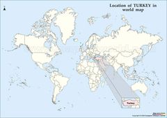
Location of Turkey Map
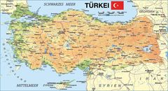
Map of Turkey
Map Turkey
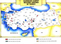
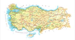
Turkeymap
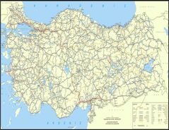
Turkey Map
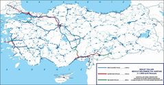
Turkey Map 2
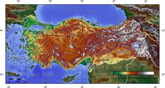
Turkey Topografical Map
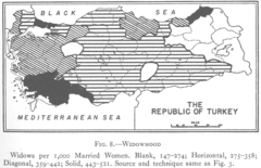
1927 Widowhood Turkey
800px Sevr Antlasmasi
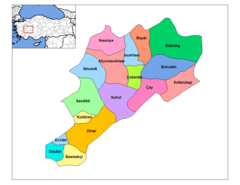
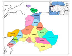
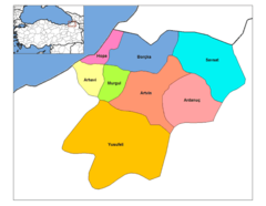
Afyonkarahisar Districts
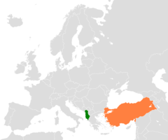
Albania Turkey Locator 1

Alevis
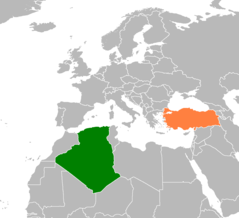
Algeria Turkey Locator 1
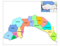
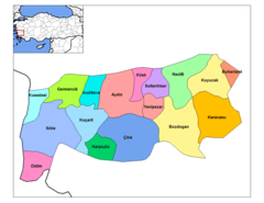
Antalya Districts
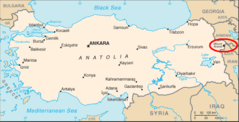
Ararat Location
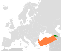
Armenia Turkey Locator 2
Artvin Districts
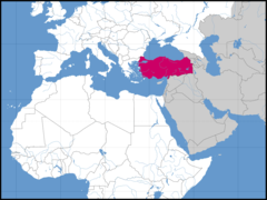
Asia Location Tur
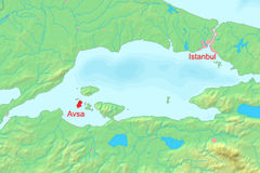
Avsha Marmara Map
Aydin Districts