Thane, Maharashtra
Thane:
About
County Snapshot
Thane at a glance
Thane currently has 13 quality-checked populated place pages linked on MapSof, making it easier to jump from the county overview into local city pages.
Mapped populated places
13
These counts use a stricter populated-place filter so the main lists stay focused on real city and town pages.
Maharashtra counties
15
Open related pagesLargest city
KalyānPopulation 1,262,255
Top linked places
Quick Facts about Thane
| State | Maharashtra (India) |
| Latitude & Longitude | 19.3333,73.2500 |
| Time Zone | Asia/Kolkata |
| Local time | 08:20:06 (10th June 2026) |
Geography
Thane is located at 19°19'60"N 73°15'0"E (19.3333300, 73.2500000).
Thane map
Click "full screen"  icon to open full mode. View satellite images
The largest city of Thane is Badlapur with a population of 104,636. . See all Thane cities & populated places.
Distretto di Thane, District de Thane, Districte de Thana, Distrito de Thane, THN, Thana, Thane District, Thāna, Thāne, Tkhane, mntqt thyn, ta na xian, tane mavattam, thana jillo, thane jil'ha, thane jila, thane jilla, thanemandalam, Тхане, تھانہ ضلع, ضلع تھانے, منطقة ثين, ठाणे, ठाणे जिला, ठाणे जिल्ला, ठाणे जिल्हा, ठाणेमण्डलम्, થાણા જિલ્લો, ଥାନେ ଜିଲ୍ଲା, டாணே மாவட்டம், ఠాణే జిల్లా, 塔納縣
Map & Images (more maps)
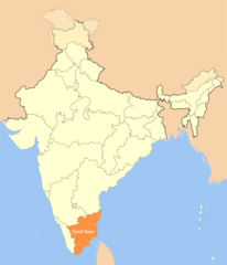
Location Map of Tamil Nadu
1714 x 2000
- 102,163k -
png
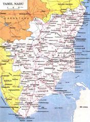
Map of Tamil Nadu
768 x 1044
- 157,390k -
jpg