Sierra Leone (Republic of Sierra Leone), SL
Sierra Leone: Located in West Africa, Sierra Leone is known for its diverse landscapes, from savannas to rainforests, and its significant mineral resources, particularly diamonds.
About

Country Snapshot
Republic of Sierra Leone at a glance
Republic of Sierra Leone currently has 66 quality-checked populated place pages and 4 state or regional pages linked on MapSof.
Mapped cities & towns
66
These counts use a stricter populated-place filter so the main lists stay focused on real city and town pages.
States & regions
4
Open related pagesLargest city
FreetownPopulation 951,000
Top linked places
Quick Facts about Republic of Sierra Leone
| Population | 9,077,691 |
| Country | Sierra Leone |
| Plate code | WAL |
| Area | 71740 km2 |
| Official name | Sierra Leone, la République de Sierra Leone, Repubblica della Sierra Leone |
| Water as percent of area | 0.2% |
| Land as percent of area | 99.8% |
| Continent | Africa |
| Northernmost point | Point(-11.5 10.0) |
| Latitude & Longitude | 8.5000,-11.5000 |
| Legislative body | Parliament of Sierra Leone |
| Named for | Lion Mountains |
| Official language | English |
| Capital | Freetown |
| Establishment | April 19, 1971 (55 years ago) |
| Time Zone | UTC±00:00 |
| Local time | 08:21:08 (10th June 2026) |

Geography
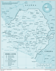
Republic of Sierra Leone is located at 8°30'0"N 11°30'0"W (8.5000000, -11.5000000). It has 2 neighbors: Liberia and Guinea.
Sierra Leone map
The largest city of Republic of Sierra Leone is Freetown with a population of 951,000. Other cities include, Kenema population 143,137, Port Loko population 21,308, Kabala population 17,948 and Bonthe population 9,647. See all Republic of Sierra Leone cities & populated places.
Official website of Republic of Sierra Leone
Official WebsiteCompare Republic of Sierra Leone with
- North West Province
- Southern Province
- Northern Province
- Western Area
- Eastern Province
Demographics
| Year | Population | % Change | Method |
|---|---|---|---|
| 1960 | 2,160,111 | - | census |
| 1961 | 2,189,040 | 1.32% | census |
| 1962 | 2,219,498 | 1.37% | census |
| 1963 | 2,251,563 | 1.42% | census |
| 1964 | 2,285,313 | 1.48% | census |
| 1965 | 2,320,858 | 1.53% | census |
| 1966 | 2,358,225 | 1.58% | census |
| 1967 | 2,397,572 | 1.64% | census |
| 1968 | 2,439,310 | 1.71% | census |
| 1969 | 2,483,952 | 1.8% | census |
| 1970 | 2,531,874 | 1.89% | census |
| 1971 | 2,583,200 | 1.99% | census |
| 1972 | 2,637,861 | 2.07% | census |
| 1973 | 2,695,784 | 2.15% | census |
| 1974 | 2,756,810 | 2.21% | census |
| 1975 | 2,820,782 | 2.27% | census |
| 1976 | 2,887,735 | 2.32% | census |
| 1977 | 2,957,599 | 2.36% | census |
| 1978 | 3,029,965 | 2.39% | census |
| 1979 | 3,104,305 | 2.39% | census |
| 1980 | 3,180,237 | 2.39% | census |
| 1981 | 3,255,883 | 2.32% | census |
| 1982 | 3,330,947 | 2.25% | census |
| 1983 | 3,408,340 | 2.27% | census |
| 1984 | 3,492,174 | 2.4% | census |
| 1985 | 3,584,397 | 2.57% | census |
| 1986 | 3,688,492 | 2.82% | census |
| 1987 | 3,800,961 | 2.96% | census |
| 1988 | 3,908,478 | 2.75% | census |
| 1989 | 3,993,016 | 2.12% | census |
| 1990 | 4,042,678 | 1.23% | census |
| 1991 | 4,053,257 | 0.26% | census |
| 1992 | 4,031,730 | -0.53% | census |
| 1993 | 3,991,434 | -1.01% | census |
| 1994 | 3,951,544 | -1.01% | census |
| 1995 | 3,927,105 | -0.62% | census |
| 1996 | 3,919,708 | -0.19% | census |
| 1997 | 3,928,313 | 0.22% | census |
| 1998 | 3,961,869 | 0.85% | census |
| 1999 | 4,030,443 | 1.7% | census |
| 2000 | 4,139,757 | 2.64% | census |
| 2001 | 4,295,667 | 3.63% | census |
| 2002 | 4,493,047 | 4.39% | census |
| 2003 | 4,712,763 | 4.66% | census |
| 2004 | 4,928,175 | 4.37% | census |
| 2005 | 5,119,895 | 3.74% | census |
| 2006 | 5,280,909 | 3.05% | census |
| 2007 | 5,416,015 | 2.49% | census |
| 2008 | 5,532,139 | 2.1% | census |
| 2009 | 5,641,182 | 1.93% | census |
| 2010 | 5,751,976 | 1.93% | census |
| 2011 | 5,865,491 | 1.94% | census |
| 2012 | 5,978,727 | 1.89% | census |
| 2013 | 6,092,075 | 1.86% | census |
| 2014 | 7,017,144 | 13.18% | (Worldbank) |
| 2015 | 7,092,113 | 1.06% | census |
| 2016 | 7,328,838 | 3.23% | (Worldbank) |
| 2017 | 7,557,212 | 3.02% | census |
| 2018 | 7,650,154 | 1.21% | (Worldbank) |
| 2019 | 7,813,215 | 2.09% | (Worldbank) |
| 2026 | 9,077,691 | 13.93% |
Map & Images (more maps)
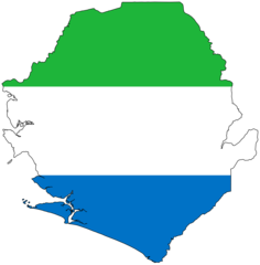
Sierra Leone Flag Map
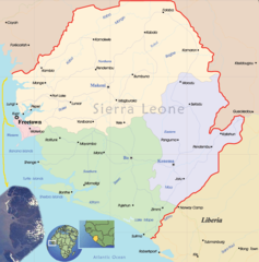
Sierra Leone Political Map
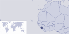
Where Is Sierra Leone Located