San Antonio, Texas
San Antonio: The seventh most populous city in the United States and the center of the San Antonio metropolitan area.
About
San Antonio is a city located in the county of Bexar in the U.S. state of Texas. Its population at the 2010 census was 1,327,407 and a population density of 1,098 people per km². After 10 years in 2020 city had an estimated population of 1,567,118 inhabitants.
The city was created 308 years ago in 1717.
San Antonio, Texas is located in south-central Texas. With a population of over 1.5 million, it is the second most populous city in Texas and the seventh largest city in the United States.
San Antonio is known for its rich history and culture. The city was founded in 1718 by Spanish explorers, which gives it a unique blend of Colonial Spanish and Mexican influence. Some of the most popular attractions that reflect San Antonio's history and culture include:
- The Alamo - This famous mission and site of the 1836 Battle of the Alamo attracts over 2.5 million visitors per year. It's considered the "Shrine of Texas Liberty."
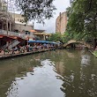
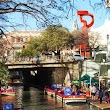
- The River Walk - This lively pedestrian walkway along the San Antonio River is lined with shops, restaurants, and bars. It's one of the most popular tourist destinations in Texas.
- San Fernando Cathedral - Founded in 1731, this is the oldest cathedral in the United States and contains ornate Spanish colonial architecture.
- Market Square - Also known as El Mercado, this busy plaza features stalls selling handcrafted goods, Mexican imports, and food in a festive environment.
San Antonio is also known for its cuisine, especially Tex-Mex dishes like chili con carne and breakfast tacos. Popular foods include puffy tacos, churros, and margaritas.
Another major attraction is the San Antonio Missions National Historical Park. These five Spanish frontier missions, including the Alamo, showcase 18th-century colonial architecture and farm life.
San Antonio has a strong military presence as home to several major bases like Joint Base San Antonio and Lackland Air Force Base. It's nicknamed "Military City USA."

Quick Facts about San Antonio
| Population | 1,567,118 (2020) |
| Country | United States of America |
| State | Texas (United States) |
| County | Bexar County |
| Different from | San Antonio |
| Twitter username | cosagov |
| Postal code | 78283 |
| Phone Area Codes | 210 |
| Area | 1208.78 km2 |
| Official name | San Antonio |
| Continent | North America |
| Latitude & Longitude | 29.4241,-98.4936 |
| Named for | Anthony of Padua |
| Altitude | 650 feet / 198 meters |
| Capital city | San Antonio is capital of Bexar County, Spanish Texas |
| Establishment | January 01, 1718 (308 years ago) |
| Time Zone | UTC−06:00 |
| Local time | 07:13:29 (10th June 2026) |
| Density | 1,296 Pop. per km² as of 2020 |
| Population growth | 15.3% (2010-2020) |
| Weather | 75℉ Mostly Cloudy 7-days weather |

Geography
San Antonio is located at 29°25'27"N 98°29'37"W (29.4241200, -98.4936300).
San Antonio map
Weather
Mostly cloudy, with a low around 75. South southeast wind around 5 mph.
7-Day Forecast- Chennai (2008 )
- Darmstadt
- Guadalajara
- Gwangju
- Kaohsiung
- Kumamoto
- Las Palmas de Gran Canaria
- Monterrey
- Santa Cruz de Tenerife
- Torreón
- Wuxi
Demographics
The population of San Antonio increased by 15.3% in 10 years.
| Year | Population | % Change | Method |
|---|---|---|---|
| 1850 | 3,488 | - | census |
| 1860 | 8,235 | 57.64% | census |
| 1870 | 12,256 | 32.81% | census |
| 1880 | 20,550 | 40.36% | census |
| 1890 | 37,673 | 45.45% | census |
| 1900 | 53,321 | 29.35% | census |
| 1910 | 96,614 | 44.81% | census |
| 1920 | 161,379 | 40.13% | census |
| 1930 | 231,542 | 30.3% | census |
| 1940 | 253,854 | 8.79% | census |
| 1950 | 408,442 | 37.85% | census |
| 1960 | 587,718 | 30.5% | census |
| 1970 | 654,153 | 10.16% | census |
| 1980 | 785,940 | 16.77% | census |
| 1990 | 935,933 | 16.03% | census |
| 2000 | 1,144,646 | 18.23% | census |
| 2005 | 1,256,810 | 8.92% | census |
| 2010 | 1,327,407 | 5.32% | census |
| 2011 | 1,357,120 | 2.19% | estimation process |
| 2012 | 1,383,075 | 1.88% | estimation process |
| 2013 | 1,408,339 | 1.79% | estimation process |
| 2014 | 1,435,456 | 1.89% | estimation process |
| 2015 | 1,464,043 | 1.95% | estimation process |
| 2016 | 1,487,843 | 1.6% | estimation process |
| 2017 | 1,511,154 | 1.54% | estimation process |
| 2018 | 1,530,016 | 1.23% | estimation process |
| 2019 | 1,547,253 | 1.11% | estimation process |
| 2020 | 1,567,118 | 1.27% | estimation process |
Best Things to Do in San Antonio
1San Antonio River Walk
849 E Commerce St, San Antonio, TX 78205, United States View details
Phone: +12102274262 | Website available
2SeaWorld San Antonio
10500 Sea World Dr, San Antonio, TX 78251, United States View details
Phone: +12105204732 | Website available

3Japanese Tea Garden
3853 N St Mary's St, San Antonio, TX 78212, United States View details
Phone: +12105593148 | Website available

4Ripley's Believe It or Not!
307 Alamo Plaza, San Antonio, TX 78205, United States View details
Phone: +12102249299 | Website available
5GO RIO San Antonio River Cruises
809 River Walk St, San Antonio, TX 78205, United States View details
Phone: +12102274746 | Website available

Services and Civic Places in San Antonio
1Olmos Park City Hall
120 W El Prado Dr, San Antonio, TX 78212 View details
Phone: +12108243281 | Website available

2City Hall San Antonio
100 Military Plaza #4, San Antonio, TX 78205 View details
Phone: +12102076000 | Website available

3Castle Hills Texas
209 Lemonwood Dr, San Antonio, TX 78213 View details
Phone: +12103422341 | Website available
4San Antonio Municipal Records
719 S Santa Rosa Ave, San Antonio, TX 78204 View details
Phone: +12102074214 | Website available
5Councilwoman Ana E. Sandoval, District 7
4414 Centerview Dr #160, San Antonio, TX 78228 View details
Phone: +12102070870 | Website available

6Garden Ridge City Hall (Rathaus)
9400 Municipal Pkwy, San Antonio, TX 78266 View details
Phone: +12106516632

7City Of Balcones Heights
3300 Hillcrest Dr, San Antonio, TX 78201 View details
Phone: +12107359149 | Website available
8Hollywood Park Police Department
2 Mecca Dr, San Antonio, TX 78232 View details
Phone: +12104943575 | Website available
9District 3 City Council Office
3315 Sidney Brooks #100, San Antonio, TX 78235 View details
Phone: +12102070969 | Website available

10District 5 City Council Office
211 N Park Blvd, San Antonio, TX 78204 View details
Phone: +12102070963
People born in San Antonio (200)
People born in San Antonio, including boxer Jesse James Leija, archer Lindsey Carmichael, actress Michelle Rodriguez, .
More notable people
- Alberto Gonzales (80th United States Attorney General) he was born in 04/08/1955
- Rick Riordan (American author most notably known for penning "the Percy Jackson and the Olympians" books) he was born in 05/06/1964
- Jared Padalecki (American actor) he was born in 19/07/1982
- Edward Higgins White (American astronaut) he was born in 14/11/1930
- Jessica Drake (American movie actress) she was born in 14/10/1974
- Summer Glau (actress from the United States) she was born in 24/07/1981
- Veronica Stevens (American professional wrestler) she was born in 19/07/1973
- Carol Burnett (American actress, comedienne, singer, dancer, writer) she was born in 26/04/1933
- Callie Khouri (American screenwriter, producer and director) she was born in 27/11/1957
- Michael E. Ryan (Chief of Staff of the United States Air Force) he was born in 24/12/1941
- Dorian Leigh (American model (1917-2008)) she was born in 23/04/1917
- Paula Prentiss (American actress) she was born in 04/03/1938
- David Scott (American engineer, retired U.S. Air Force officer, former test pilot, and former NASA astronaut) he was born in 06/06/1932
- Yolanda Saldívar (American convicted murderer) she was born in 19/09/1960
- Robert Quiroga (American boxer) he was born in 10/10/1969
- Doug Sahm (American country music and blues rock musician) he was born in 06/11/1941
- Augie Meyers (American musician and singer) he was born in 31/05/1940
- Oliver North (US Marine Corps lieutenant colonel, claimed partial responsibility for clandestinely selling weapons to Iran and channeling profits to Contras in Nicaragua) he was born in 07/10/1943
Nearby Schools and Colleges
Schools and campuses linked to San Antonio, TX. Select a name to open its map and contact details.
| Code | Name | City | ZIP |
|---|---|---|---|
| 227924 | San Antonio College | San Antonio (TX) | 78212-3941 |
| 227854 | St Philip's College | San Antonio (TX) | 78203-2098 |
| 229267 | Trinity University | San Antonio (TX) | 78212-7200 |
| 377272 | Nuvani Institute | San Antonio (TX) | 78212-1901 |
| 225627 | University of the Incarnate Word | San Antonio (TX) | 78209 |
Nearby Transit Stations (3)
Rail and bus stations connected to San Antonio, TX. Select a station to open its map and address details.
| Code | Name | Address | Type |
|---|---|---|---|
| SAS | San Antonio Station | 350 Hoefgen Street | RAIL |
| SMC | San Marcos Station | 338 South Guadalupe St. | RAIL |
| AUS | Austin | 250 North Lamar Blvd. | RAIL |
Closest post offices linked to San Antonio.
| Post Office Name | City | ZIP |
|---|---|---|
| Arsenal Post Office | San Antonio (TX) | 78204 |
| Downtown San Anton Post Office | San Antonio (TX) | 78205 |
| Laurel Heigh Post Office | San Antonio (TX) | 78212 |
| Wainwrigh Post Office | San Antonio (TX) | 78208 |
| Hackberry Post Office | San Antonio (TX) | 78210 |
Other places with the same name (13)
- San Antonio, Central Luzon with a population of 34,217 people.
- San Antonio, Central Luzon with a population of 26,247 people.
- San Antonio, Bicol with a population of 4,374 people.
- San Antonio, Calabarzon with a population of 2,929 people.
- San Antonio, Cagayan Valley with a population of 2,810 people.
- San Antonio, Western Visayas with a population of 2,646 people.
- San Antonio, Central Luzon with a population of 2,607 people.
- San Antonio, Central Luzon with a population of 2,568 people.
- San Antonio, Cagayan Valley with a population of 2,488 people.
- San Antonio, Davao with a population of 2,356 people.
- San Antonio, Central Luzon with a population of 2,332 people.
- San Antonio, Eastern Visayas with a population of 2,325 people.
- San Antonio, Calabarzon with a population of 2,259 people.
Other cities in Bexar County
Cities, towns, neighborhoods & other populated places in Bexar County , TX. (more)
| City Name | Population | Title |
|---|---|---|
| Converse | 28,814 | City |
| Universal City | 20,890 | Community in the San Fernando Valley region of Los Angeles County, California |
| Timberwood Park | 13,447 | Census designated place |
| Selma | 13,130 | City in Bexar County, Texas, United States |
| Leon Valley | 12,301 | City in Texas |
| Fair Oaks Ranch | 10,345 | City in the U. |
| Helotes | 10,277 | City in Bexar County, Texas, United States |
| Kirby | 8,719 | City in Bexar County, Texas, United States |
| Alamo Heights | 8,668 | City in Bexar County, Texas, United States |
| Windcrest | 5,854 | City in Bexar County, Texas, United States |
| Terrell Hills | 5,451 | City in Bexar County, Texas, United States |
| Scenic Oaks | 4,957 | Census designated place |
| Sandy Oaks | 4,787 | City in Bexar County, Texas, United States of America |
| Castle Hills | 4,448 | City in Bexar County, Texas, United States |
| Shavano Park | 4,024 | City in Bexar County, Texas, United States |
| Hollywood Park | 3,328 | Town of the United States |
Distance to Other Cities
San Antonio distances to largest Texas cities