Philippines (Republic of the Philippines), PH
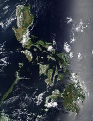
Philippines: An archipelagic nation in Southeast Asia, it comprises over 7, 640 islands in the Pacific Ocean.
About

Country Snapshot
Republic of the Philippines at a glance
Republic of the Philippines currently has 2,833 quality-checked populated place pages and 4 state or regional pages linked on MapSof.
Mapped cities & towns
2,833
These counts use a stricter populated-place filter so the main lists stay focused on real city and town pages.
States & regions
4
Open related pagesLargest city
Cavite CityPopulation 3,678,301
Top linked places
Quick Facts about Republic of the Philippines
| Population | 114,123,600 |
| Country | Philippines |
| Plate code | RP |
| Area | 343448 km2 |
| Official name | République des Philippines, Republic of the Philippines, Republika ng Pilipinas |
| Continent | Asia |
| Easternmost point | Point(126.604444444 7.293333333) |
| Northernmost point | Point(121.95 21.12) |
| Latitude & Longitude | 13.0000,122.0000 |
| Legislative body | Congress of the Philippines |
| Named for | Philip II of Spain |
| Official language | Filipino, English |
| Capital | Manila |
| Establishment | January 01, 1565 (461 years ago) |
| Time Zone | Philippine Standard Time |
| Local time | 02:27:58 (10th June 2026) |

Geography
Republic of the Philippines is located at 13°0'0"N 122°0'0"E (13.0000000, 122.0000000). It has 4 neighbors: Palau, Indonesia, Taiwan and Malaysia.
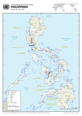
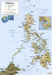
Philippines map
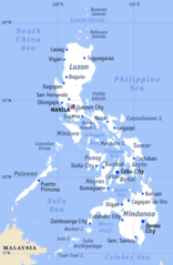
The largest city of Republic of the Philippines is Manila with a population of 1,780,148. Other cities include, Antipolo population 776,386, Bacolod City population 561,875, Calamba population 454,486 and Angeles City population 411,634. See all Republic of the Philippines cities & populated places.
Official website of Republic of the Philippines
Official WebsiteCompare Republic of the Philippines with
- Northern Mindanao
- Ilocos Region
- Central Visayas
- Bicol Region
- Bangsamoro
- Metro Manila
- Eastern Visayas
- Davao Region
- Soccsksargen
- Cagayan Valley
- Caraga
- Central Luzon
- Western Visayas
- Calabarzon
- Zamboanga Peninsula
- Cordillera Administrative Region
- Negros Island Region
- Mimaropa
Demographics
| Year | Population | % Change | Method |
|---|---|---|---|
| 1799 | 1,502,574 | - | census |
| 1800 | 1,561,251 | 3.76% | census |
| 1812 | 1,933,331 | 19.25% | census |
| 1819 | 2,106,230 | 8.21% | census |
| 1829 | 2,593,287 | 18.78% | census |
| 1840 | 3,096,031 | 16.24% | census |
| 1850 | 3,857,424 | 19.74% | census |
| 1858 | 4,290,381 | 10.09% | census |
| 1870 | 4,712,006 | 8.95% | census |
| 1877 | 5,567,685 | 15.37% | census |
| 1887 | 5,984,727 | 6.97% | census |
| 1896 | 6,261,339 | 4.42% | census |
| 1903 | 7,635,426 | 18% | census |
| 1918 | 10,314,310 | 25.97% | census |
| 1939 | 16,000,303 | 35.54% | census |
| 1948 | 19,234,182 | 16.81% | census |
| 1960 | 27,087,685 | 28.99% | census |
| 1961 | 27,164,618 | 0.28% | census |
| 1962 | 28,081,234 | 3.26% | census |
| 1963 | 29,016,770 | 3.22% | census |
| 1964 | 29,962,877 | 3.16% | census |
| 1965 | 30,913,931 | 3.08% | census |
| 1966 | 31,867,565 | 2.99% | census |
| 1967 | 32,826,602 | 2.92% | census |
| 1968 | 33,797,041 | 2.87% | census |
| 1969 | 34,787,588 | 2.85% | census |
| 1970 | 36,684,486 | 5.17% | census |
| 1971 | 36,851,055 | 0.45% | census |
| 1972 | 37,925,400 | 2.83% | census |
| 1973 | 39,026,082 | 2.82% | census |
| 1974 | 40,149,959 | 2.8% | census |
| 1975 | 42,070,660 | 4.57% | census |
| 1976 | 42,461,189 | 0.92% | census |
| 1977 | 43,650,333 | 2.72% | census |
| 1978 | 44,866,279 | 2.71% | census |
| 1979 | 46,113,992 | 2.71% | census |
| 1980 | 48,098,460 | 4.13% | census |
| 1981 | 48,715,592 | 1.27% | census |
| 1982 | 50,068,493 | 2.7% | census |
| 1983 | 51,455,037 | 2.69% | census |
| 1984 | 52,873,979 | 2.68% | census |
| 1985 | 54,323,651 | 2.67% | census |
| 1986 | 55,803,915 | 2.65% | census |
| 1987 | 57,312,794 | 2.63% | census |
| 1988 | 58,844,392 | 2.6% | census |
| 1989 | 60,391,168 | 2.56% | census |
| 1990 | 60,703,206 | 0.51% | census |
| 1991 | 63,509,940 | 4.42% | census |
| 1992 | 65,078,901 | 2.41% | census |
| 1993 | 66,654,954 | 2.36% | census |
| 1994 | 68,240,134 | 2.32% | census |
| 1995 | 68,616,536 | 0.55% | census |
| 1996 | 71,437,381 | 3.95% | census |
| 1997 | 73,042,605 | 2.2% | census |
| 1998 | 74,656,228 | 2.16% | census |
| 1999 | 76,285,225 | 2.14% | census |
| 2000 | 76,506,928 | 0.29% | census |
| 2001 | 79,604,541 | 3.89% | census |
| 2002 | 81,294,378 | 2.08% | census |
| 2003 | 82,971,734 | 2.02% | census |
| 2004 | 84,596,249 | 1.92% | census |
| 2005 | 86,141,373 | 1.79% | census |
| 2006 | 87,592,899 | 1.66% | census |
| 2007 | 88,566,732 | 1.1% | census |
| 2008 | 90,297,115 | 1.92% | census |
| 2009 | 91,641,881 | 1.47% | census |
| 2010 | 93,038,902 | 1.5% | census |
| 2011 | 94,501,233 | 1.55% | census |
| 2012 | 96,017,322 | 1.58% | census |
| 2013 | 97,571,676 | 1.59% | census |
| 2014 | 100,513,138 | 2.93% | (Worldbank) |
| 2015 | 100,981,437 | 0.46% | census |
| 2016 | 103,663,927 | 2.59% | (Worldbank) |
| 2017 | 105,173,264 | 1.44% | (Worldbank) |
| 2018 | 106,651,922 | 1.39% | (Worldbank) |
| 2019 | 108,116,615 | 1.35% | (Worldbank) |
| 2026 | 114,123,600 | 5.26% |
Map & Images (more maps)
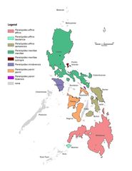
Genera Penelopides
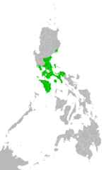
Katagalugan
Majorvolcanoesofthephilippines Usgs
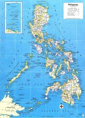
Map of Philippines
Map of Rrsea Philippines
Map of the Philippines Demis
Map Philippines
Map Philippines 2005
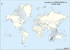
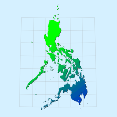
Philipines Location Map
Philippines Country Map
Philippines
Philippines 1
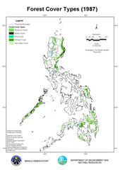
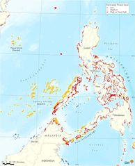
Philippines Forest Cover 1987
Philippines General Map
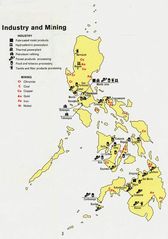
Philippines Industry And Mining
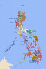
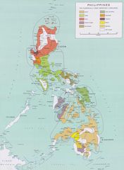
Philippines Languages
Philippines Large
Philippines Map
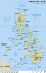
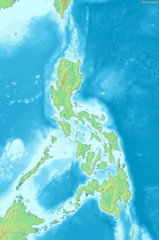
Philippines Physical Map
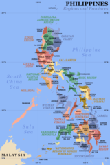
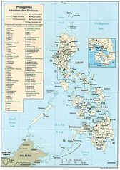
Philippines Regions And Provinces