Pasay City (City of Pasay), Metro Manila
Pasay City: city of the Philippines in Metro Manila
About
Quick Facts about City of Pasay
| Population | 416,522 |
| Country | Philippines |
| State | Metro Manila (Philippines) |
| County | Southern Manila District |
| Different from | Paoay |
| Postal code | 1300–1309 |
| Phone Area Codes | 2 |
| Area | 13.97 km2 |
| Official name | City of Pasay |
| Has part | Malibay |
| Latitude & Longitude | 14.5500,121.0000 |
| Establishment | December 02, 1863 (162 years ago) |
| Time Zone | UTC+08:00 |
| Local time | 19:50:17 (9th June 2026) |
Geography
City of Pasay is located at 14°33'0"N 121°0'0"E (14.5500000, 121.0000000). It has 2 neighbors: Taguig and Manila.
Pasay City map
Click "full screen"  icon to open full mode. View satellite images
Official website of City of Pasay
Official Website- Sacramento
- Tainan
Demographics
| Year | Population | % Change | Method |
|---|---|---|---|
| 1903 | 8,201 | - | census |
| 1918 | 18,697 | 56.14% | census |
| 1939 | 55,161 | 66.1% | census |
| 1948 | 88,728 | 37.83% | census |
| 1960 | 132,673 | 33.12% | census |
| 1970 | 206,283 | 35.68% | census |
| 1975 | 254,999 | 19.1% | census |
| 1980 | 287,770 | 11.39% | census |
| 1990 | 368,366 | 21.88% | census |
| 1995 | 408,610 | 9.85% | census |
| 2000 | 354,908 | -15.13% | census |
| 2007 | 403,064 | 11.95% | census |
| 2010 | 392,869 | -2.6% | census |
| 2015 | 416,522 | 5.68% | census |
Lungsod ng Pasay, Lungsód ng Pasay, Pasay, Rizal, Rizal City, Santa Clara
Map & Images (more maps)
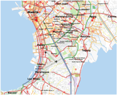
Pasay Location
1179 x 955
- 218,849k -
png
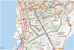
Pasay City Map
1481 x 1003
- 306,823k -
png
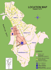
Pasay City Location Map
944 x 1281
- 183,337k -
png