New Hampshire, US
New Hampshire: Located in the New England region of the northeastern United States, this state is known for its expansive forests, mountains, and picturesque coastline.
About
New Hampshire is a small state located in the New England region of the northeastern United States. It is bordered by Canada, Maine, Vermont, and Massachusetts. New Hampshire is known for its rugged natural beauty and "Live Free or Die" motto.
Some key facts about New Hampshire:
- Capital: Concord
- Population: Around 1.4 million
- Area: 9,349 square miles (46th largest state)
- Nickname: The Granite State
New Hampshire has a primarily mountainous landscape dotted with lakes, forests, and quaint small towns. The White Mountains region is popular for hiking and skiing. Other major natural features include Lake Winnipesaukee and the Appalachian Trail.
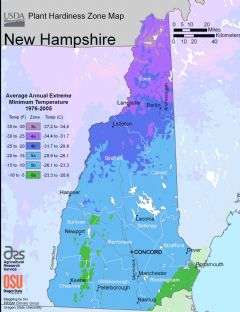
New Hampshire has four distinct seasons that bring vibrant fall foliage, summer recreation, winter snow sports, and spring blooms. The climate varies across the state based on elevation and proximity to the Atlantic coastline.
Culturally, New Hampshire prides itself on independence and freedom. There is no state income tax or sales tax. The state motto “Live Free or Die” exemplifies the spirit of liberty. Politically, New Hampshire is best known for hosting the first presidential primary every four years.
Major industries include technology, tourism, manufacturing, forestry, and agriculture. The state is home to Dartmouth College and other excellent universities. The cities of Manchester and Nashua are industrial and economic hubs.
In summary, New Hampshire is emblematic of New England with its natural wonders, independent culture, and quaint village charm. The state's stunning vistas and "Live Free" philosophy make it a distinct place to visit and call home.

State Snapshot
New Hampshire at a glance
New Hampshire currently has 235 quality-checked populated place pages and 10 county pages linked on MapSof.
Mapped cities & towns
235
These counts use a stricter populated-place filter so the main lists stay focused on real city and town pages.
County pages
10
Open related pagesLargest city
ManchesterPopulation 112,546
Top linked places
Quick Facts about New Hampshire
| Population | 1,366,275 |
| Country | United States of America |
| Area | 24214 km2 |
| Water as percent of area | 4.24% |
| Land as percent of area | 95.76% |
| Continent | North America |
| Latitude & Longitude | 43.6670,-71.4998 |
| Legislative body | New Hampshire General Court |
| Named for | Hampshire |
| Official language | English |
| Altitude | 1,001 feet / 305 meters |
| Capital | Concord |
| Establishment | June 21, 1788 (238 years ago) |
| Time Zone | Eastern Time Zone, America/New_York |
| Local time | 06:02:44 (21st July 2026) |

Geography
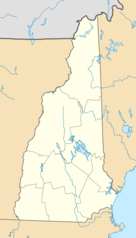
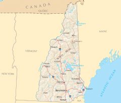
New Hampshire is located at 43°40'1"N 71°29'59"W (43.6670200, -71.4998000). It has 4 neighbors: Maine, Vermont, Quebec and Massachusetts.
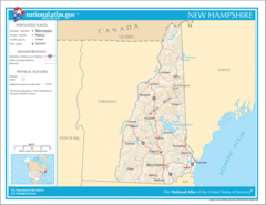
New Hampshire map
The largest city of New Hampshire is Manchester with a population of 112,546. Other cities include, Nashua population 89,167, Concord population 43,924, East Concord population 42,605 and Derry Village population 34,539. See all New Hampshire cities & populated places.
Largest Cities in New Hampshire (more)
Cities, Towns, Villages, Neighborhoods & Other Populated Places in New Hampshire.
| City Name | County | Population |
|---|---|---|
| Manchester | Hillsborough | 112,546 |
| Nashua | Hillsborough | 89,167 |
| Concord | Merrimack | 43,924 |
| East Concord | Merrimack | 42,605 |
| Derry Village | Rockingham | 34,539 |
| Derry | Rockingham | 33,442 |
| Dover | Strafford | 32,443 |
| Rochester | Strafford | 31,719 |
| Salem | Rockingham | 30,641 |
| Merrimack | Hillsborough | 27,452 |
| Londonderry | Rockingham | 26,646 |
| Hudson | Hillsborough | 25,620 |
| Bedford | Hillsborough | 22,957 |
| Keene | Cheshire | 22,699 |
| Portsmouth | Rockingham | 21,557 |
| Goffstown | Hillsborough | 18,136 |
Show more New Hampshire cities and populated places
Official website of New Hampshire
Official Website- Belknap County
- Rockingham County
- Hillsborough County
- Sullivan County
- Carroll County
- Cheshire County
- Coös County
- Strafford County
- Grafton County
- Merrimack County
Demographics
| Year | Population | % Change | Method |
|---|---|---|---|
| 1910 | 430,572 | - | census |
| 1920 | 443,083 | 2.82% | census |
| 1930 | 465,293 | 4.77% | census |
| 1940 | 491,524 | 5.34% | census |
| 1950 | 533,242 | 7.82% | census |
| 1960 | 606,921 | 12.14% | census |
| 1970 | 737,681 | 17.73% | census |
| 1980 | 920,610 | 19.87% | census |
| 1990 | 1,109,252 | 17.01% | census |
| 2000 | 1,235,786 | 10.24% | census |
| 2010 | 1,316,470 | 6.13% | census |
| 2011 | 1,320,202 | 0.28% | estimation process |
| 2012 | 1,324,232 | 0.3% | estimation process |
| 2013 | 1,326,622 | 0.18% | estimation process |
| 2014 | 1,333,341 | 0.5% | estimation process |
| 2015 | 1,336,350 | 0.23% | estimation process |
| 2016 | 1,342,307 | 0.44% | estimation process |
| 2017 | 1,348,787 | 0.48% | estimation process |
| 2018 | 1,353,465 | 0.35% | estimation process |
| 2019 | 1,359,711 | 0.46% | estimation process |
| 2020 | 1,366,275 | 0.48% | estimation process |
People born in New Hampshire (120)
People born in New Hampshire, including rock climber Dean Potter, botanist Alphonso Wood, Union Army officer Henry William Blair, .
More notable people
- Benjamin Tyler Henry (American gunsmith and manufacturer) he was born in 22/03/1821
- Charles H. Bell (American politician (1823-1893)) he was born in 18/11/1823
- Taylor Haskins (American musician) he was born in 07/11/1971
- Carson Cistulli (American poet and writer) he was born in 23/12/1979
- Frank Merrill (United States Army general (1903-1955)) he was born in 04/12/1903
- Kedron Barrett (American artist) he was born in 01/01/1961
- Joseph Alexander Ames (American artist (1816-1872)) he was born in 01/01/1816
- Jim Laurier (American illustrator) he was born in 01/01/1954
- John Ordway (American explorer) he was born in 01/01/1775
- John Stark (American Revolutionary War general from New Hampshire) he was born in 28/08/1728
- Nehemiah G. Ordway (American politician (1828-1907)) he was born in 10/11/1828
- Will Sheff (American musician) he was born in 07/07/1976
- Louis Bell (American physicist) he was born in 05/12/1864
- Phoebe Foster (American actress) she was born in 09/07/1895
- Nat Faxon (American actor) he was born in 11/10/1975
- Adam Warren (American comic book writer) he was born in 01/01/1967
- Anders Nilsen (artist) he was born in 01/01/1973
- Jennifer Fleischer (American basketball player) she was born in 17/02/1984
New Hampshire Counties
Hillsborough County

The most populous county in the U.
Rockingham County

county in New Hampshire, United States
Merrimack County

county in New Hampshire, United States
| County Name | Population |
|---|---|
| Hillsborough County | 418,735 |
| Rockingham County | 311,307 |
| Merrimack County | 152,622 |
| Strafford County | 131,533 |
| Grafton County | 90,691 |
| Cheshire County | 76,228 |
| Belknap County | 61,551 |
| Carroll County | 49,167 |
| Sullivan County | 43,267 |
| Coos County | 31,174 |
Show more New Hampshire counties
Map & Images (more maps)
Map of New Hampshire Na 1
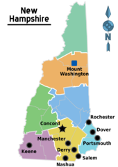
Map of New Hampshire Regions
New Hampshire Road Map
Usa New Hampshire Location Map
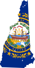
New Hampshire Flag Map
New Hampshire Cities And Towns
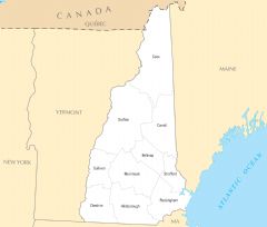
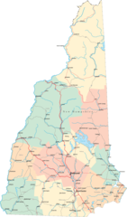
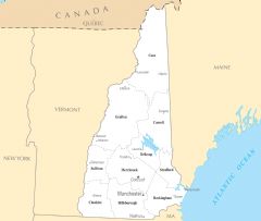
New Hampshire County Map
New Hampshire Reference Map
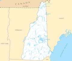
New Hampshire Rivers And Lakes