Mexico, MX
Mexico: Located in southern North America, it is a country with a rich history and diverse culture.
About

Country Snapshot
Mexico at a glance
Mexico currently has 1,627 quality-checked populated place pages and 32 state or regional pages linked on MapSof.
Mapped cities & towns
1,627
These counts use a stricter populated-place filter so the main lists stay focused on real city and town pages.
States & regions
32
Open related pagesLargest city
Mexico CityPopulation 8,918,653
Quick Facts about Mexico
| Population | 130,575,786 |
| Country | Mexico |
| Twitter username | mexico |
| Plate code | MEX |
| Area | 1972550 km2 |
| Official name | Unuiĝintaj Ŝtatoj de Meksiko, الولايات المكسيكية المتحدة, Estaos Xuníos Mexicanos, Մեքսիկայի Միացյալ Նահանգներ, États-Unis mexicains, Estados Unidos Mexicanos, Estats Units Mexicans, Estados Unidos Mexicanos, Unol Daleithiau Mecsico, Vereinigte Mexikanische Staaten, les États unis mexicains |
| Continent | North America |
| Easternmost point | Point(-86.74072981 21.135385) |
| Northernmost point | Point(-114.719722222 32.718888888) |
| Latitude & Longitude | 23.0000,-102.0000 |
| Legislative body | Congress of the Union |
| Official language | Spanish, Nahuatl, Yucatec Maya, languages of Mexico |
| Capital | Mexico City |
| Time Zone | Central Time Zone, Pacific Time Zone, Mountain Time Zone, Eastern Time Zone |
| Local time | 03:35:44 (21st July 2026) |

Geography
Mexico is located at 23°0'0"N 102°0'0"W (23.0, -102.0). It has 3 neighbors: Belize, Guatemala and United States.
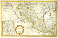
Mexico map
The largest city of Mexico is Mexico City with a population of 8,918,653. Other cities include, Ecatepec de Morelos population 1,655,015, Guadalajara population 1,495,182, Ciudad Juárez population 1,321,004 and Ciudad Nezahualcoyotl population 1,104,585. See all Mexico cities & populated places.
Official website of Mexico
Go to Official Website Go to Official Website Go to Official Website TwitterCompare Mexico with
- Sonora
- Nuevo León
- Morelos
- Tabasco
- Querétaro
- Michoacán
- Guanajuato
- State of Mexico
- Mexico City
- Chihuahua
- Jalisco
- Chiapas
- Oaxaca
- Durango
- Campeche
- San Luis Potosí
- Yucatán
- Veracruz
- Aguascalientes
- Coahuila
- Guerrero
- Colima
- Baja California Sur
- Tamaulipas
- Tlaxcala
- Baja California
- Hidalgo
- Zacatecas
- Nayarit
- Sinaloa
- Puebla
- Quintana Roo
Demographics
| Year | Population | % Change | Method |
|---|---|---|---|
| 1960 | 38,676,974 | - | census |
| 1961 | 39,939,271 | 3.16% | census |
| 1962 | 41,234,350 | 3.14% | census |
| 1963 | 42,564,038 | 3.12% | census |
| 1964 | 43,931,398 | 3.11% | census |
| 1965 | 45,338,827 | 3.1% | census |
| 1966 | 46,783,542 | 3.09% | census |
| 1967 | 48,264,496 | 3.07% | census |
| 1968 | 49,787,609 | 3.06% | census |
| 1969 | 51,360,846 | 3.06% | census |
| 1970 | 52,988,138 | 3.07% | census |
| 1971 | 54,669,034 | 3.07% | census |
| 1972 | 56,395,803 | 3.06% | census |
| 1973 | 58,155,590 | 3.03% | census |
| 1974 | 59,931,341 | 2.96% | census |
| 1975 | 61,708,369 | 2.88% | census |
| 1976 | 63,486,196 | 2.8% | census |
| 1977 | 65,261,295 | 2.72% | census |
| 1978 | 67,012,869 | 2.61% | census |
| 1979 | 68,715,443 | 2.48% | census |
| 1980 | 70,353,013 | 2.33% | census |
| 1981 | 71,916,281 | 2.17% | census |
| 1982 | 73,415,735 | 2.04% | census |
| 1983 | 74,880,326 | 1.96% | census |
| 1984 | 76,351,106 | 1.93% | census |
| 1985 | 77,859,344 | 1.94% | census |
| 1986 | 79,410,218 | 1.95% | census |
| 1987 | 80,999,175 | 1.96% | census |
| 1988 | 82,635,332 | 1.98% | census |
| 1989 | 84,326,921 | 2.01% | census |
| 1990 | 86,077,004 | 2.03% | census |
| 1991 | 87,890,094 | 2.06% | census |
| 1992 | 89,757,916 | 2.08% | census |
| 1993 | 91,653,826 | 2.07% | census |
| 1994 | 93,541,577 | 2.02% | census |
| 1995 | 95,392,647 | 1.94% | census |
| 1996 | 97,201,533 | 1.86% | census |
| 1997 | 98,968,558 | 1.79% | census |
| 1998 | 100,678,867 | 1.7% | census |
| 1999 | 102,316,781 | 1.6% | census |
| 2000 | 103,873,607 | 1.5% | census |
| 2001 | 105,339,877 | 1.39% | census |
| 2002 | 106,723,661 | 1.3% | census |
| 2003 | 108,056,312 | 1.23% | census |
| 2004 | 109,381,550 | 1.21% | census |
| 2005 | 110,731,826 | 1.22% | census |
| 2006 | 112,116,694 | 1.24% | census |
| 2007 | 113,529,819 | 1.24% | census |
| 2008 | 114,968,039 | 1.25% | census |
| 2009 | 116,422,752 | 1.25% | census |
| 2010 | 112,336,538 | -3.64% | census |
| 2011 | 119,361,233 | 5.89% | census |
| 2012 | 120,847,449 | 1.23% | census |
| 2013 | 122,332,399 | 1.21% | census |
| 2014 | 120,355,128 | -1.64% | (Worldbank) |
| 2015 | 121,858,258 | 1.23% | (Worldbank) |
| 2016 | 123,333,376 | 1.2% | (Worldbank) |
| 2017 | 130,526,945 | 5.51% | census |
| 2018 | 126,190,788 | -3.44% | (Worldbank) |
| 2019 | 127,575,529 | 1.09% | (Worldbank) |
| 2026 | 130,575,786 | 2.3% |
Map & Images (more maps)
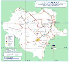
Durango Mexico Road Map