Manila, Metro Manila
Manila: Located on the eastern shore of Manila Bay in the southwestern part of Luzon, this densely populated city is the capital of the Philippines.
About

Quick Facts about Manila
| Population | 1,780,148 |
| Country | Philippines |
| State | Metro Manila (Philippines) |
| County | Capital District |
| Postal code | 0900–1096 |
| Phone Area Codes | 2 |
| Area | 38.55 km2 |
| Official name | City of Manila, Lungsod ng Maynila |
| Latitude & Longitude | 14.6042,120.9822 |
| Capital city | Manila is capital of Captaincy General of the Philippines, Philippines, Commonwealth of the Philippines, Philippines, National Capital Region First District, Metro Manila, Spanish East Indies |
| Establishment | July 04, 1571 (454 years ago) |
| Time Zone | Philippine Standard Time |
| Local time | 02:45:29 (10th June 2026) |

Ph seal ncr manila seal image
Geography
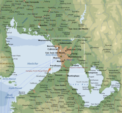
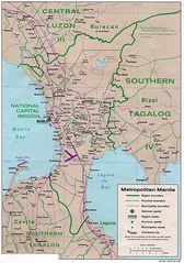
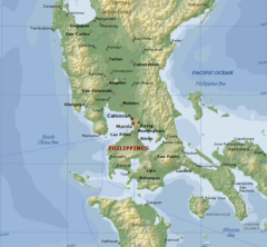
Manila is located at 14°36'15"N 120°58'56"E (14.6042000, 120.9822000). It has 4 neighbors: Quezon City, Pasay City, Navotas and Caloocan City.
Manila map
Click "full screen"  icon to open full mode. View satellite images
Official website of Manila
Official Website- Acapulco de Juárez
- Bangkok (1997 )
- Beijing
- Bucharest
- Busan
- Cali
- Cartagena
- Guam
- Guangzhou
- Haifa
- Havana
- Ho Chi Minh City
- Honolulu County
- Incheon
- Jakarta
- Jersey City
- Lima
- Los Angeles
- Lyon
- Madrid
- Maui County
- Mexico City
- Montreal
- Moscow
- Málaga
- New Delhi
- Nice
- Nur-Sultan
- Panama City
- Sacramento
- San Francisco
- Santa Barbara
- Santiago
- Seberang Perai
- Shanghai (1983 )
- Sydney
- Taichung
- Taipei (1966 )
- Takatsuki
- Tehran
- Winnipeg
- Yokohama
- Ōsaka
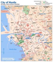
- Ermita
- Binondo
- Santa Cruz
- Quiapo
- Pandacan
- San Miguel
- Santa Mesa
- San Nicolas
- Malate
- Port Area
- Intramuros
- Tondo
- Santa Ana
- Paco
- Sampaloc
Demographics
| Year | Population | % Change | Method |
|---|---|---|---|
| 1903 | 219,928 | - | census |
| 1918 | 285,306 | 22.92% | census |
| 1939 | 623,492 | 54.24% | census |
| 1948 | 983,906 | 36.63% | census |
| 1960 | 1,138,611 | 13.59% | census |
| 1970 | 1,330,788 | 14.44% | census |
| 1975 | 1,479,116 | 10.03% | census |
| 1980 | 1,630,485 | 9.28% | census |
| 1990 | 1,601,234 | -1.83% | census |
| 1995 | 1,654,761 | 3.23% | census |
| 2000 | 1,581,082 | -4.66% | census |
| 2007 | 1,660,714 | 4.8% | census |
| 2010 | 1,652,171 | -0.52% | census |
| 2015 | 1,780,148 | 7.19% | census |
City of Manila, Dakbayan sa Manila, Lungsod ng Maynila, MNL, Mainile, Manilae, Manilla, Manillah, Manille, Manilo, Manyl, Maníla, Maynila, Menila, ma ni la, manira, manyla, mnila, mnylh, myanila, Μανίλα, Манилæ, Манила, Маніла, מנילה, مانىلا, مانيلا, مانیل, مانیلا, मनिला, मनीला, ম্যানিলা, மணிலா, ಮನಿಲ, මැනිලා, มนิลา, มะนิลา, མ་ནི་ལ།, မနီလာမြို့, მანილა, ማኒላ, マニラ, 马尼拉, 마닐라
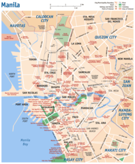
Map & Images (more maps)
Manila City
800 x 740
- 54,973k -
png
Manila Map
1078 x 1534
- 303,845k -
jpg
Manila Philippines
800 x 740
- 98,984k -
png
Map of Manila
1200 x 1409
- 287,012k -
png
Manila City Map
920 x 1115
- 150,925k -
png
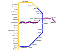
Manila Metro Map
697 x 528
- 5,710k -
png