Louisa, Kentucky
Louisa: city in Lawrence County, Kentucky, USA
About
Louisa is a city located in the county of Lawrence in the U.S. state of Kentucky. Its population at the 2010 census was 2,467 and a population density of 421 people per km². After 10 years in 2020 city had an estimated population of 2,325 inhabitants.
The city was created 203 years ago in 1822.
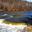
Louisa is a home rule-class city located at the merger of the Levisa and Tug Forks into the Big Sandy River. It is located in Lawrence County, Kentucky, in the United States, and is the seat of its county. The population was 2,467 at the 2010 census and an estimated 2,375 in 2018.
Louisa is part of the Huntington-Ashland Metropolitan Statistical Area (MSA).
The city is named for Louisa Crittenden Bailey, wife of William Bailey who aided in establishing the city. Louisa was established as a town by an act of legislature on December 11, 1822. In 1823 it became the county seat after being chosen over nearby Catlettsburg.
In 1824 Louisa had 750 residents, three taverns and several stores along with a post office and schoolhouse. Also that year it was made a stop on a stagecoach route between Lexington and Charleston via Harrodsburg. By 1832 there were over 1,000 people living in Louisa. In 1833 the Louisville & Nashville Railroad came through Louisa; this resulted in more growth for the community.[citation needed]
During World War I some soldiers trained at Camp Taylor near Louisa before departing

Quick Facts about Louisa
| Population | 2,325 (2020) |
| Country | United States of America |
| State | Kentucky (United States) |
| County | Lawrence County |
| Phone Area Codes | 606 |
| Area | 5.86 km2 |
| Latitude & Longitude | 38.1143,-82.6032 |
| Altitude | 584 feet / 178 meters |
| Capital city | Louisa is capital of Lawrence County |
| Establishment | December 11, 1822 (203 years ago) |
| Time Zone | America/New_York |
| Local time | 18:28:11 (9th June 2026) |
| Postal code | 41230 |
| Density | 397 Pop. per km² as of 2020 |
| Population growth | -6.11% (2010-2020) |
| Weather | 83℉ Chance Showers And Thunderstorms 7-days weather |

Geography
Louisa is located at 38°6'51"N 82°36'12"W (38.1142500, -82.6032100).
Louisa map
Weather
A slight chance of showers and thunderstorms before 7am, then a chance of showers and thunderstorms between 7am and 11am, then a chance of showers and...
7-Day ForecastOfficial website of Louisa
Official WebsiteDemographics
According to census records, the population of Louisa decreased by 6.11% in 10 years.
| Year | Population | % Change | Method |
|---|---|---|---|
| 2010 | 2,467 | - | census |
| 2011 | 2,462 | -0.2% | estimation process |
| 2012 | 2,454 | -0.33% | estimation process |
| 2013 | 2,449 | -0.2% | estimation process |
| 2014 | 2,441 | -0.33% | estimation process |
| 2015 | 2,433 | -0.33% | estimation process |
| 2016 | 2,423 | -0.41% | estimation process |
| 2017 | 2,404 | -0.79% | estimation process |
| 2018 | 2,372 | -1.35% | estimation process |
| 2019 | 2,327 | -1.93% | estimation process |
| 2020 | 2,325 | -0.09% | estimation process |
Best Things to Do in Louisa
1Lockview Park
805 N Lock Ave, Louisa, KY 41230, United States View details
Website available
2Main Street Park
150 E Main St, Louisa, KY 41230, United States View details
Phone: +16066384050 | Website available

Where to Eat in Louisa
1Giovanni's Pizza
403 N Lock Ave, Louisa, KY 41230, United States View details
Phone: +16066389053 | Website available

2KFC
2864 KY-2565, Louisa, KY 41230, United States View details
Phone: +16066389636 | Website available
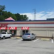
3Burger King
115 Louisa Plaza, Louisa, KY 41230, United States View details
Phone: +16066389354 | Website available

4Little Caesars Pizza
US 23 OLD BYPASS, Louisa, KY 41230, United States View details
Phone: +16066380300 | Website available

5Subway
2565 Old U.S. 23, Louisa, KY 41230, United States View details
Phone: +16066380300 | Website available

Where to Stay in Louisa
1Best Western Plus Louisa
18199 Highway 23, Louisa, KY 41230, United States View details
Phone: +16066383418 | Website available

2Lawrence Co. Campground & Cabins
77 Wilderness Rd, Louisa, KY 41230, United States View details
Phone: +16068262961

Services and Civic Places in Louisa
1Department of Fish & Wildlife
2194 State Hwy 1185, Louisa, KY 41230, United States View details
Phone: +16066863312
Nearby Schools and Colleges
Schools and campuses linked to Louisa, KY. Select a name to open its map and contact details.
| Code | Name | City | ZIP |
|---|---|---|---|
| 444954 | Mountwest Community and Technical College | Huntington (WV) | 25701 |
Nearby Transit Stations (6)
Rail and bus stations connected to Louisa, KY. Select a station to open its map and address details.
| Code | Name | Address | Type |
|---|---|---|---|
| HUN | Huntington | 1050 8th Avenue | RAIL |
| AKY | Ashland Transportation Center | 99 15th Street | RAIL |
| SPM | South Portsmouth–South Shore station | Main St & US 23 | RAIL |
| CHW | Charleston | 350 MacCorkle Avenue - Southeast | RAIL |
| MNG | Montgomery | Third Avenue and Washington Street | RAIL |
Closest post offices linked to Louisa.
| Post Office Name | City | ZIP |
|---|---|---|
| Louisa Post Office | Louisa (KY) | 41230 |
Other places with the same name (1)
- Louisa, Virginia county in Virginia, United States with a population of 1,764 people.
Other cities in Lawrence County
Cities, towns, neighborhoods & other populated places in Lawrence County , KY.
| City Name | Population | Title |
|---|---|---|
| Blaine | 44 | City in Kentucky, USA |
Distance to Other Cities
Louisa distances to largest Kentucky cities