Japan, JP
Japan: Independent country in East Asia, situated on an archipelago of five main and over 6, 800 smaller islands
About

Country Snapshot
Japan at a glance
Japan currently has 657 quality-checked populated place pages and 47 state or regional pages linked on MapSof.
Mapped cities & towns
657
These counts use a stricter populated-place filter so the main lists stay focused on real city and town pages.
States & regions
47
Open related pagesLargest city
TokyoPopulation 13,942,856
Top linked places
Quick Facts about Japan
| Population | 123,210,000 |
| Country | Japan |
| Twitter username | JapanGov, japan |
| Plate code | J |
| Area | 377972.28 km2 |
| Official name | 日本国, le Japon |
| Has part | Western Japan, island of Japan, Eastern Japan, region of Japan, Central Japan, Southern Japan, Northern Japan |
| Continent | Asia |
| Annual number of weddings | 635156, 621000 |
| Easternmost point | Point(153.986388888 24.283055555), Point(145.817555555 43.385361111) |
| Northernmost point | Point(141.936583333 45.523027777), Point(141.936388888 45.522777777), Point(148.752222222 45.557222222) |
| Latitude & Longitude | 35.6854,139.7531 |
| Legislative body | National Diet |
| Official language | Japanese |
| Capital | Nagaoka-kyō, Heian-kyō, Heijō-kyō, Tokyo, Edo, Fukuhara-kyō, Shigaraki Palace |
| Time Zone | Japan Standard Time |
| Local time | 11:43:11 (9th June 2026) |

Geography
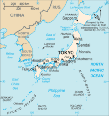
Japan is located at 35°41'7"N 139°45'11"E (35.6853600, 139.7530900). It has 6 neighbors: Taiwan, Philippines, China, South Korea, Russia and United States.
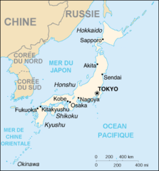
Japan map
The largest city of Japan is Tokyo with a population of 13,942,856. Other cities include, Nagoya population 2,325,918, Sapporo population 1,958,756, Kawasaki population 1,530,457 and Kyoto population 1,466,264. See all Japan cities & populated places.
Compare Japan with
- Nagasaki Prefecture
- Toyama Prefecture
- Miyagi Prefecture
- Akita Prefecture
- Ibaraki Prefecture
- Tochigi Prefecture
- Fukushima Prefecture
- Kumamoto Prefecture
- Ishikawa Prefecture
- Yamagata Prefecture
- Wakayama Prefecture
- Nagano Prefecture
- Kagoshima Prefecture
- Shizuoka Prefecture
- Iwate Prefecture
- Okinawa Prefecture
- Aichi Prefecture
- Gunma Prefecture
- Ehime Prefecture
- Fukui Prefecture
- Gifu Prefecture
- Fukuoka Prefecture
- Ōsaka Prefecture
- Saitama Prefecture
- Hyōgo Prefecture
- Aomori Prefecture
- Yamanashi Prefecture
- Mie Prefecture
- Tokushima Prefecture
- Hokkaidō
- Shimane Prefecture
- Ōita Prefecture
- Niigata Prefecture
- Nara Prefecture
- Chiba Prefecture
- Kagawa Prefecture
- Kyōto Prefecture
- Kōchi Prefecture
- Saga Prefecture
- Miyazaki Prefecture
- Tottori Prefecture
- Yamaguchi Prefecture
- Hiroshima Prefecture
- Shiga Prefecture
- Kanagawa Prefecture
- Tokyo
- Okayama Prefecture
Demographics
| Year | Population | % Change | Method |
|---|---|---|---|
| 1960 | 92,500,572 | - | (Worldbank) |
| 1961 | 94,943,000 | 2.57% | (Worldbank) |
| 1962 | 95,832,000 | 0.93% | (Worldbank) |
| 1963 | 96,812,000 | 1.01% | (Worldbank) |
| 1964 | 97,826,000 | 1.04% | (Worldbank) |
| 1965 | 98,883,000 | 1.07% | (Worldbank) |
| 1966 | 99,790,000 | 0.91% | (Worldbank) |
| 1967 | 100,725,000 | 0.93% | (Worldbank) |
| 1968 | 101,061,000 | 0.33% | (Worldbank) |
| 1969 | 103,172,000 | 2.05% | (Worldbank) |
| 1970 | 104,345,000 | 1.12% | (Worldbank) |
| 1971 | 105,697,000 | 1.28% | (Worldbank) |
| 1972 | 107,188,000 | 1.39% | (Worldbank) |
| 1973 | 108,079,000 | 0.82% | (Worldbank) |
| 1974 | 110,162,000 | 1.89% | (Worldbank) |
| 1975 | 111,940,000 | 1.59% | (Worldbank) |
| 1976 | 112,771,000 | 0.74% | (Worldbank) |
| 1977 | 113,863,000 | 0.96% | (Worldbank) |
| 1978 | 114,898,000 | 0.9% | (Worldbank) |
| 1979 | 115,870,000 | 0.84% | (Worldbank) |
| 1980 | 116,782,000 | 0.78% | (Worldbank) |
| 1981 | 117,648,000 | 0.74% | (Worldbank) |
| 1982 | 118,449,000 | 0.68% | (Worldbank) |
| 1983 | 119,259,000 | 0.68% | (Worldbank) |
| 1984 | 120,018,000 | 0.63% | (Worldbank) |
| 1985 | 120,754,000 | 0.61% | (Worldbank) |
| 1986 | 121,492,000 | 0.61% | (Worldbank) |
| 1987 | 122,091,000 | 0.49% | (Worldbank) |
| 1988 | 122,613,000 | 0.43% | (Worldbank) |
| 1989 | 123,116,000 | 0.41% | (Worldbank) |
| 1990 | 123,537,000 | 0.34% | (Worldbank) |
| 1991 | 123,921,000 | 0.31% | (Worldbank) |
| 1992 | 124,229,000 | 0.25% | (Worldbank) |
| 1993 | 124,536,000 | 0.25% | (Worldbank) |
| 1994 | 124,961,000 | 0.34% | (Worldbank) |
| 1995 | 125,570,246 | 0.49% | census |
| 1996 | 125,757,000 | 0.15% | (Worldbank) |
| 1997 | 126,057,000 | 0.24% | (Worldbank) |
| 1998 | 126,400,000 | 0.27% | (Worldbank) |
| 1999 | 126,631,000 | 0.18% | (Worldbank) |
| 2000 | 126,925,843 | 0.23% | census |
| 2001 | 127,149,000 | 0.18% | (Worldbank) |
| 2002 | 127,445,000 | 0.23% | (Worldbank) |
| 2003 | 127,718,000 | 0.21% | (Worldbank) |
| 2004 | 127,761,000 | 0.03% | (Worldbank) |
| 2005 | 127,767,994 | 0.01% | census |
| 2006 | 127,854,000 | 0.07% | (Worldbank) |
| 2007 | 128,001,000 | 0.11% | (Worldbank) |
| 2008 | 128,063,000 | 0.05% | (Worldbank) |
| 2009 | 128,047,000 | -0.01% | (Worldbank) |
| 2010 | 128,057,352 | 0.01% | census |
| 2011 | 127,833,000 | -0.18% | (Worldbank) |
| 2012 | 127,629,000 | -0.16% | (Worldbank) |
| 2013 | 127,445,000 | -0.14% | (Worldbank) |
| 2014 | 127,276,000 | -0.13% | (Worldbank) |
| 2015 | 127,094,745 | -0.14% | census |
| 2016 | 126,994,511 | -0.08% | (Worldbank) |
| 2017 | 126,785,797 | -0.16% | census |
| 2018 | 126,434,565 | -0.28% | Sevastopol |
| 2019 | 126,309,690 | -0.1% | Sevastopol |
| 2020 | 125,961,625 | -0.28% | Sevastopol |
| 2026 | 123,210,000 | -2.23% |
Map & Images (more maps)
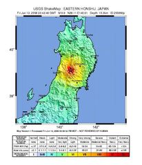
2008 Iwate Earthquake Intensity
Ancient Japan Provinces Map Japanese
Ancient Japan Provinces Map
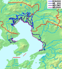
Ariake Sea Coastline
Cartedujapon
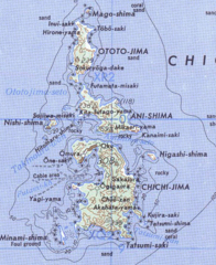
Chichijima Retto
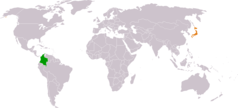
Colombia Japan Locator
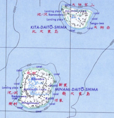
Daito Shoto
Dokdo Map
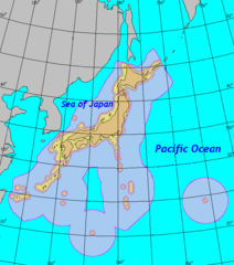
Eez of Japan
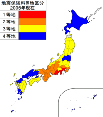
Earthquake Insurance Consultation of Japan 2005
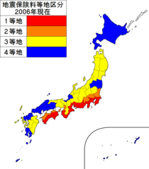
Earthquake Insurance Consultation of Japan 2006
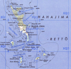
Hahajima Retto
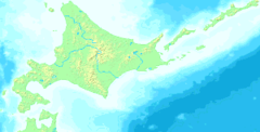
Hokkaido Map Small
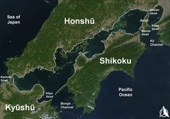
Inlandsea
Ja Map
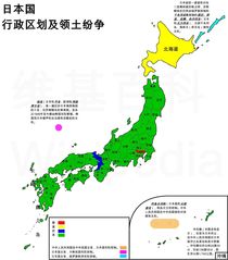
Japan Administrative Zh Cn
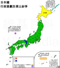
Japan Administrative Zh Tw
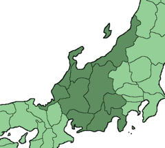
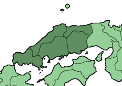
Japan Chubu Region
Japan Chugoku Region Large