Ghana (Republic of Ghana), GH
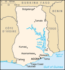
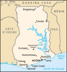
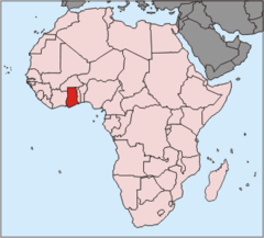
Ghana: Located in West Africa, this nation borders the Gulf of Guinea and the Atlantic Ocean to its south, sharing land borders with Togo to the east, Côte d'Ivoire to the west, and Burkina Faso to the north.
About

Country Snapshot
Republic of Ghana at a glance
Republic of Ghana currently has 45 quality-checked populated place pages and 9 state or regional pages linked on MapSof.
Mapped cities & towns
45
These counts use a stricter populated-place filter so the main lists stay focused on real city and town pages.
States & regions
9
Open related pagesLargest city
WaPopulation 2,656,156
Top linked places
Quick Facts about Republic of Ghana
| Population | 33,742,380 |
| Country | Ghana, Portuguese Empire |
| Plate code | GH |
| Area | 238535 km2 |
| Official name | Ghana, Ghana, la République du Ghana |
| Continent | Africa |
| Easternmost point | Point(1.19948387 6.11239242) |
| Northernmost point | Point(-0.27 11.17) |
| Latitude & Longitude | 8.1000,-1.2000 |
| Legislative body | Parliament of Ghana |
| Named for | Ghana Empire |
| Official language | English |
| Capital | Accra |
| Establishment | January 01, 1957 (69 years ago) |
| Time Zone | UTC±00:00 |
| Local time | 15:31:47 (24th July 2026) |

Geography
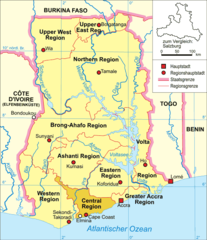
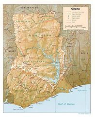
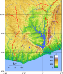
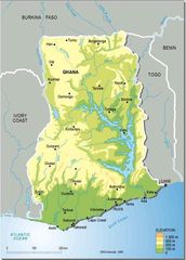
Republic of Ghana is located at 8°6'0"N 1°12'0"W (8.1000000, -1.2000000). It has 3 neighbors: Ivory Coast, Burkina Faso and Togo.
Ghana map
The largest city of Republic of Ghana is Accra with a population of 2,270,000. Other cities include, Hohoe population 56,202, Winneba population 44,254, Konongo population 41,238 and Axim population 24,500. See all Republic of Ghana cities & populated places.
Compare Republic of Ghana with
- Central Region
- Greater Accra Region
- Northern Region
- Volta Region
- Eastern Region
- Ashanti Region
- Upper East Region
- Western Region
- Upper West Region
- Brong-Ahafo Region
Demographics
| Year | Population | % Change | Method |
|---|---|---|---|
| 1960 | 6,652,516 | - | estimation process |
| 1961 | 6,866,780 | 3.12% | estimation process |
| 1962 | 7,085,698 | 3.09% | estimation process |
| 1963 | 7,303,664 | 2.98% | estimation process |
| 1964 | 7,513,510 | 2.79% | estimation process |
| 1965 | 7,710,761 | 2.56% | estimation process |
| 1966 | 7,891,194 | 2.29% | estimation process |
| 1967 | 8,057,629 | 2.07% | estimation process |
| 1968 | 8,221,194 | 1.99% | estimation process |
| 1969 | 8,397,508 | 2.1% | estimation process |
| 1970 | 8,597,133 | 2.32% | estimation process |
| 1971 | 8,827,429 | 2.61% | estimation process |
| 1972 | 9,083,737 | 2.82% | estimation process |
| 1973 | 9,350,286 | 2.85% | estimation process |
| 1974 | 9,604,475 | 2.65% | estimation process |
| 1975 | 9,831,636 | 2.31% | estimation process |
| 1976 | 10,023,738 | 1.92% | estimation process |
| 1977 | 10,190,202 | 1.63% | estimation process |
| 1978 | 10,354,855 | 1.59% | estimation process |
| 1979 | 10,551,189 | 1.86% | estimation process |
| 1980 | 10,802,497 | 2.33% | estimation process |
| 1981 | 11,118,132 | 2.84% | estimation process |
| 1982 | 11,488,683 | 3.23% | estimation process |
| 1983 | 11,895,742 | 3.42% | estimation process |
| 1984 | 12,311,805 | 3.38% | estimation process |
| 1985 | 12,716,887 | 3.19% | estimation process |
| 1986 | 13,104,616 | 2.96% | estimation process |
| 1987 | 13,480,997 | 2.79% | estimation process |
| 1988 | 13,853,171 | 2.69% | estimation process |
| 1989 | 14,233,006 | 2.67% | estimation process |
| 1990 | 14,628,693 | 2.7% | estimation process |
| 1991 | 15,043,053 | 2.75% | estimation process |
| 1992 | 15,471,695 | 2.77% | estimation process |
| 1993 | 15,907,265 | 2.74% | estimation process |
| 1994 | 16,339,278 | 2.64% | estimation process |
| 1995 | 16,760,926 | 2.52% | estimation process |
| 1996 | 17,169,151 | 2.38% | estimation process |
| 1997 | 17,568,461 | 2.27% | estimation process |
| 1998 | 17,968,830 | 2.23% | estimation process |
| 1999 | 18,384,302 | 2.26% | estimation process |
| 2000 | 18,825,034 | 2.34% | estimation process |
| 2001 | 19,293,392 | 2.43% | estimation process |
| 2002 | 19,786,307 | 2.49% | estimation process |
| 2003 | 20,301,686 | 2.54% | estimation process |
| 2004 | 20,835,514 | 2.56% | estimation process |
| 2005 | 21,384,034 | 2.57% | estimation process |
| 2006 | 21,947,779 | 2.57% | estimation process |
| 2007 | 22,525,659 | 2.57% | estimation process |
| 2008 | 23,110,139 | 2.53% | estimation process |
| 2009 | 23,691,533 | 2.45% | estimation process |
| 2010 | 24,200,000 | 2.1% | estimation process |
| 2011 | 24,820,706 | 2.5% | estimation process |
| 2012 | 25,366,462 | 2.15% | estimation process |
| 2013 | 25,904,598 | 2.08% | estimation process |
| 2014 | 27,224,472 | 4.85% | (Worldbank) |
| 2015 | 27,849,205 | 2.24% | (Worldbank) |
| 2016 | 28,308,301 | 1.62% | estimation process |
| 2017 | 26,908,262 | -5.2% | estimation process |
| 2018 | 29,767,108 | 9.6% | (Worldbank) |
| 2019 | 30,417,856 | 2.14% | (Worldbank) |
| 2026 | 33,742,380 | 9.85% |
Map & Images (more maps)
000 Gana Harta

At0111 Map

At0707 Map

At0722 Map 1
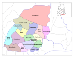
Ashanti Districts
Brong Ahafo Districts
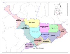
Central Ghana Districts
Diplomatic Missions of Ghana
Eastern Ghana Districts
Gh Map
Ghana Map
Ghana Topography
Ghana Carte
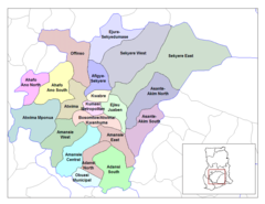
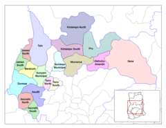
Ghana Districts
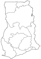
Ghana Regions Blank
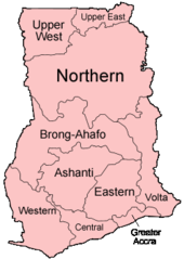
Ghana Regions Named
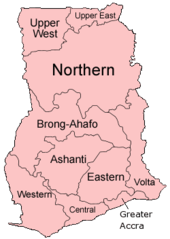
Ghana Regions
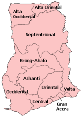
Ghana Regionsspanish
Ghana Topographic Map
Ghana Pos