Flanders, New York
Flanders: census-designated place in Suffolk County, New York
About
Flanders is a CDP located in the county of Suffolk in the U.S. state of New York.

Quick Facts about Flanders
| Population | 4,472 |
| Country | United States of America |
| State | New York (United States) |
| County | Suffolk County |
| Postal code | 11901 |
| Area | 30.27 km2 |
| Latitude & Longitude | 40.9034,-72.6176 |
| Altitude | 7 feet / 2 meters |
| Time Zone | America/New_York |
| Local time | 17:49:16 (9th June 2026) |

Geography
Flanders is located at 40°54'12"N 72°37'3"W (40.9034300, -72.6175900). It has 2 neighbors: Region de Bruxelles Capitale and Wallonia.
Flanders map
Best Things to Do in Flanders
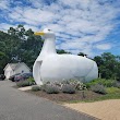
1The Big Duck
1012 NY-24, Flanders, NY 11901, United States View details
Phone: +16318523377 | Website available
People born in Flanders (47)
People born in Flanders, including Belgian collaborator Robert Jan Verbelen, German mathematician Heinrich Brucæus, Franco-Flemish Renaissance composer Heinrich Isaac, .
More notable people
- Grimbald (Benedictine monk of the Abbey of Saint Bertin) he was born in 01/01/0827
- Jean de Latre (composer) he was born in 01/01/1510
- Gerard de Ridefort (Knight Templar) he was born in 01/01/1141
- Adrianus Petit Coclico (Netherlandish composer) he was born in 01/01/1499
- Guy of Avesnes (Dutch bishop) he was born in 01/01/1253
- Rimbert (Archbishop of Bremen) he was born in 01/01/0830
- William de Croÿ (French priest) he was born in 01/01/1498
- Sylvain Geboers (Motocross racer) he was born in 01/01/1950
- William FitzOsbern, 1st Earl of Hereford (Norman earl (c. 1020–1071)) he was born in 01/01/1020
- Robert Coppens he was born in 01/01/1505
- Erwin Mortier (Flemish writer, poet and essayist) he was born in 28/11/1965
- Jost de Laval he was born in 01/01/1500
- Rosine De Dijn (German journalist and author) she was born in 01/01/1941
- Louis Pevernagie (Belgian painter (1904-1970)) he was born in 01/01/1904
- Susannah Hornebolt (English artist (1503-1545)) she was born in 01/01/1503
- Ignacio de Ries (Spanish baroque painter (c.1612-1661)) he was born in 01/01/1612
- Arendt de Roy (Dutch architect)
- Eptic (Belgian DJ (b. 1993)) he was born in 09/04/1993
Nearby Schools and Colleges
Schools and campuses linked to Flanders, NY. Select a name to open its map and contact details.
| Code | Name | City | ZIP |
|---|---|---|---|
| 486877 | Eastern Suffolk BOCES | Riverhead (NY) | 11901-2763 |
Nearby Transit Stations (19)
Rail and bus stations connected to Flanders, NY. Select a station to open its map and address details.
| Code | Name | Address | Type |
|---|---|---|---|
| OSB | Old Saybrook station | 455 Boston Post Road | RAIL |
| NHV | Union Station | 50 Union Avenue | RAIL |
| BRP | Bridgeport | 525 Water St. | RAIL |
| WFD | Wallingford station | 37 Hall Avenue | RAIL |
| NLC | New London Union Station | 27 Water Street | RAIL |
Closest post offices linked to Flanders.
| Post Office Name | City | ZIP |
|---|---|---|
| Aquebogu Post Office | Aquebogue (NY) | 11931 |
Other cities in Suffolk County
Cities, towns, neighborhoods & other populated places in Suffolk County , NY. (more)
| City Name | Population | Title |
|---|---|---|
| Brookhaven | 479,883 | This town in Suffolk County, New York, is the most populous in the state. |
| Islip | 322,328 | This Long Island community is situated on the south shore of Suffolk County, New York, at an elevation of 13 feet. |
| Babylon | 218,223 | A town in Suffolk County, New York. |
| Huntington | 200,102 | Town in Suffolk County, New York, United States |
| Smithtown | 110,876 | Census-designated place in Suffolk County, New York |
| Brentwood | 60,664 | Census-designated place in Suffolk County, New York |
| Southampton | 58,549 | Town in Suffolk County, New York, partly on the South Fork of Long Island, USA |
| West Babylon | 43,213 | Census-designated place in Suffolk County, New York |
| Coram | 39,113 | Census-designated place in Suffolk County, New York |
| Commack | 36,124 | Census-designated place in Suffolk County, New York |
| Central Islip | 34,450 | Census-designated place in Suffolk County, New York |
| Riverhead | 33,434 | Town in New York |
| Huntington Station | 33,029 | Census-designated place in Suffolk County, New York |
| Centereach | 31,578 | Census-designated place in Suffolk County, New York |
| West Islip | 28,335 | Census-designated place in Suffolk County, New York |
| Shirley | 27,854 | Census-designated place in New York, USA |
Distance to Other Cities
Flanders distances to largest New York cities