Fiji (Republic of Fiji), FJ
Fiji: Located in Melanesia in the South Pacific Ocean, this island nation comprises an archipelago of over 330 islands, of which around 110 are permanently inhabited.
About

Country Snapshot
Republic of Fiji at a glance
Republic of Fiji currently has 4 quality-checked populated place pages and 5 state or regional pages linked on MapSof.
Mapped cities & towns
4
These counts use a stricter populated-place filter so the main lists stay focused on real city and town pages.
States & regions
5
Open related pagesLargest city
SuvaPopulation 77,366
Top linked places
Quick Facts about Republic of Fiji
| Population | 900,869 |
| Country | Fiji |
| Plate code | FJI |
| Area | 18274 km2 |
| Official name | la République des Fidji, Republic of Fiji, Matanitu ko Viti, Viti, Fiji |
| Continent | Oceania |
| Easternmost point | Point(-178.25 -19.816666666) |
| Northernmost point | Point(176.98 -12.47) |
| Latitude & Longitude | -18.0000,178.0000 |
| Legislative body | Parliament of Fiji |
| Official language | English, Fiji Hindi, Fijian, Hindustani |
| Capital | Suva |
| Time Zone | UTC+12:00 |
| Local time | 06:22:10 (10th June 2026) |
Geography
Republic of Fiji is located at 18°0'0"S 178°0'0"E (-18.0000000, 178.0000000).
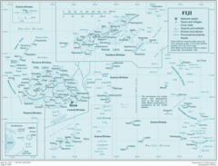
Fiji map
The largest city of Republic of Fiji is Suva with a population of 77,366. . See all Republic of Fiji cities & populated places.
Official website of Republic of Fiji
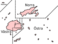
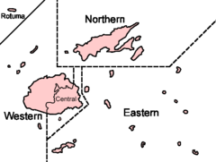
Official Website- Eastern Division
- Western Division
- Rotuma
- Central Division
- Northern Division
Demographics
| Year | Population | % Change | Method |
|---|---|---|---|
| 1960 | 393,383 | - | census |
| 1961 | 407,152 | 3.38% | census |
| 1962 | 421,576 | 3.42% | census |
| 1963 | 436,208 | 3.35% | census |
| 1964 | 450,452 | 3.16% | estimation process |
| 1965 | 463,884 | 2.9% | census |
| 1966 | 476,329 | 2.61% | estimation process |
| 1967 | 487,911 | 2.37% | census |
| 1968 | 498,887 | 2.2% | estimation process |
| 1969 | 509,659 | 2.11% | estimation process |
| 1970 | 520,529 | 2.09% | estimation process |
| 1971 | 531,601 | 2.08% | census |
| 1972 | 542,811 | 2.07% | estimation process |
| 1973 | 554,109 | 2.04% | census |
| 1974 | 565,386 | 1.99% | estimation process |
| 1975 | 576,592 | 1.94% | census |
| 1976 | 587,522 | 1.86% | census |
| 1977 | 598,256 | 1.79% | census |
| 1978 | 609,344 | 1.82% | estimation process |
| 1979 | 621,537 | 1.96% | estimation process |
| 1980 | 635,256 | 2.16% | estimation process |
| 1981 | 650,966 | 2.41% | estimation process |
| 1982 | 668,219 | 2.58% | census |
| 1983 | 685,422 | 2.51% | estimation process |
| 1984 | 700,394 | 2.14% | census |
| 1985 | 711,663 | 1.58% | estimation process |
| 1986 | 718,493 | 0.95% | estimation process |
| 1987 | 721,594 | 0.43% | census |
| 1988 | 722,707 | 0.15% | estimation process |
| 1989 | 724,355 | 0.23% | census |
| 1990 | 728,339 | 0.55% | estimation process |
| 1991 | 735,209 | 0.93% | census |
| 1992 | 744,340 | 1.23% | census |
| 1993 | 754,923 | 1.4% | census |
| 1994 | 765,664 | 1.4% | census |
| 1995 | 775,587 | 1.28% | census |
| 1996 | 784,647 | 1.15% | census |
| 1997 | 793,098 | 1.07% | estimation process |
| 1998 | 800,616 | 0.94% | census |
| 1999 | 806,857 | 0.77% | estimation process |
| 2000 | 811,647 | 0.59% | estimation process |
| 2001 | 814,700 | 0.37% | estimation process |
| 2002 | 816,237 | 0.19% | estimation process |
| 2003 | 817,224 | 0.12% | estimation process |
| 2004 | 818,995 | 0.22% | census |
| 2005 | 822,484 | 0.42% | census |
| 2006 | 828,060 | 0.67% | estimation process |
| 2007 | 835,392 | 0.88% | estimation process |
| 2008 | 843,851 | 1% | estimation process |
| 2009 | 852,479 | 1.01% | census |
| 2010 | 860,559 | 0.94% | estimation process |
| 2011 | 867,921 | 0.85% | census |
| 2012 | 874,742 | 0.78% | census |
| 2013 | 881,065 | 0.72% | census |
| 2014 | 866,453 | -1.69% | (Worldbank) |
| 2015 | 868,627 | 0.25% | (Worldbank) |
| 2016 | 915,303 | 5.1% | estimation process |
| 2017 | 905,502 | -1.08% | estimation process |
| 2018 | 883,483 | -2.49% | (Worldbank) |
| 2019 | 889,953 | 0.73% | (Worldbank) |
| 2026 | 900,869 | 1.21% |
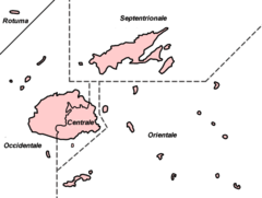
Map & Images (more maps)
Decoupageadministratifidjien
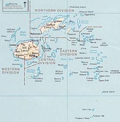
Fiji Detail
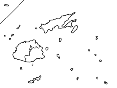
Fiji Divisions Blank
Fiji Divisions Named Sv
Fiji Divisions Named
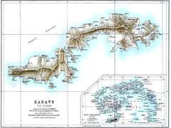
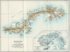
Kadavu Fiji 1889
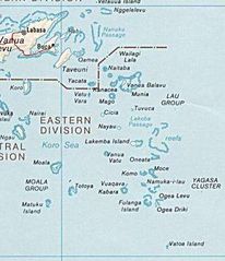
Lauislandsmap
Historical Fiji Islands (1889)