Eritrea (State of Eritrea), ER
Eritrea: This East African nation is situated along the Red Sea, bordering Sudan, Ethiopia, and Djibouti.
About
Country Snapshot
State of Eritrea at a glance
State of Eritrea currently has 7 quality-checked populated place pages and 6 state or regional pages linked on MapSof.
Mapped cities & towns
7
These counts use a stricter populated-place filter so the main lists stay focused on real city and town pages.
States & regions
6
Open related pagesLargest city
AsmaraPopulation 563,930
Top linked places
Quick Facts about State of Eritrea
| Population | 3,607,000 |
| Country | Djibouti |
| Area | 23200 km2 |
| Official name | la République de Djibouti, Jabuuti, جمهورية جيبوتي, Djibouti, République de Djibouti |
| Continent | Africa |
| Easternmost point | Point(43.41691 12.12148) |
| Northernmost point | Point(43.13 12.7) |
| Latitude & Longitude | 15.0000,39.0000 |
| Legislative body | National Assembly |
| Named for | Djibouti |
| Official language | Arabic, French |
| Capital | Djibouti |
| Establishment | June 23, 1977 (48 years ago) |
| Time Zone | UTC+03:00 |
| Local time | 07:45:32 (10th June 2026) |
Geography
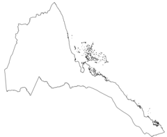
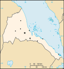
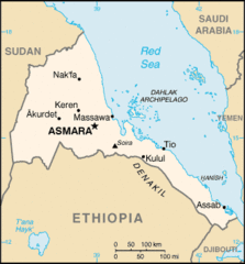
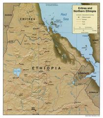
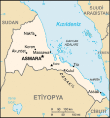
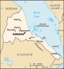
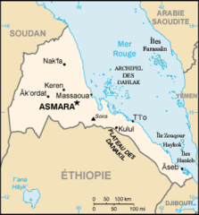
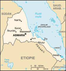
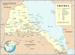
State of Eritrea is located at 15°0'0"N 39°0'0"E (15.0000000, 39.0000000). It has 3 neighbors: Djibouti, Ethiopia and Sudan.
Eritrea map
The largest city of State of Eritrea is Asmara with a population of 563,930. Other cities include, Mendefera population 17,781, Adi Keyh population 13,061 and Dek’emhāre population 10,959. See all State of Eritrea cities & populated places.
Official website of State of Eritrea
Official WebsiteCompare State of Eritrea with
- Dikhil Region
- Tadjourah Region
- Djibouti Region
- Obock Region
- Ali Sabieh Region
- Arta Region
Demographics
| Year | Population | % Change | Method |
|---|---|---|---|
| 1960 | 1,404,810 | - | census |
| 1961 | 1,438,217 | 2.32% | estimation process |
| 1962 | 1,472,966 | 2.36% | census |
| 1963 | 1,508,999 | 2.39% | census |
| 1964 | 1,546,225 | 2.41% | census |
| 1965 | 1,584,606 | 2.42% | census |
| 1966 | 1,624,256 | 2.44% | census |
| 1967 | 1,665,301 | 2.46% | estimation process |
| 1968 | 1,707,748 | 2.49% | census |
| 1969 | 1,751,590 | 2.5% | census |
| 1970 | 1,796,912 | 2.52% | estimation process |
| 1971 | 1,843,624 | 2.53% | estimation process |
| 1972 | 1,891,998 | 2.56% | estimation process |
| 1973 | 1,942,922 | 2.62% | estimation process |
| 1974 | 1,997,553 | 2.73% | estimation process |
| 1975 | 2,056,693 | 2.88% | estimation process |
| 1976 | 2,120,634 | 3.02% | census |
| 1977 | 2,189,070 | 3.13% | census |
| 1978 | 2,261,435 | 3.2% | census |
| 1979 | 2,336,862 | 3.23% | estimation process |
| 1980 | 2,414,647 | 3.22% | census |
| 1981 | 2,493,745 | 3.17% | estimation process |
| 1982 | 2,573,931 | 3.12% | estimation process |
| 1983 | 2,656,189 | 3.1% | estimation process |
| 1984 | 2,742,004 | 3.13% | estimation process |
| 1985 | 2,831,894 | 3.17% | estimation process |
| 1986 | 2,928,032 | 3.28% | estimation process |
| 1987 | 3,028,719 | 3.32% | estimation process |
| 1988 | 3,126,100 | 3.12% | census |
| 1989 | 3,209,606 | 2.6% | estimation process |
| 1990 | 3,272,563 | 1.92% | census |
| 1991 | 3,311,719 | 1.18% | estimation process |
| 1992 | 3,331,918 | 0.61% | estimation process |
| 1993 | 3,344,626 | 0.38% | estimation process |
| 1994 | 3,365,933 | 0.63% | estimation process |
| 1995 | 3,407,812 | 1.23% | census |
| 1996 | 3,473,399 | 1.89% | census |
| 1997 | 3,560,353 | 2.44% | estimation process |
| 1998 | 3,668,350 | 2.94% | census |
| 1999 | 3,795,384 | 3.35% | estimation process |
| 2000 | 3,939,348 | 3.65% | estimation process |
| 2001 | 4,101,609 | 3.96% | census |
| 2002 | 4,281,576 | 4.2% | census |
| 2003 | 4,472,533 | 4.27% | estimation process |
| 2004 | 4,665,522 | 4.14% | estimation process |
| 2005 | 4,854,066 | 3.88% | census |
| 2006 | 5,035,036 | 3.59% | estimation process |
| 2007 | 5,209,846 | 3.36% | census |
| 2008 | 5,382,163 | 3.2% | census |
| 2009 | 5,557,889 | 3.16% | estimation process |
| 2010 | 5,741,159 | 3.19% | census |
| 2011 | 5,932,852 | 3.23% | estimation process |
| 2012 | 6,130,922 | 3.23% | census |
| 2013 | 6,333,135 | 3.19% | estimation process |
| 2017 | 956,985 | -561.78% | |
| 2019 | 3,497,000 | 72.63% | estimation process |
| 2026 | 3,607,000 | 3.05% |
Map & Images (more maps)
000 Eritrea Harta

At0705 Map 3

At1007 Map 1
Dahlak Archipelago 1
Er Map
Eritrea Map
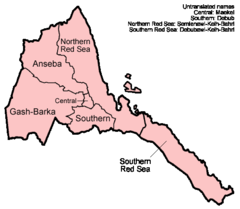
Eritrea Regions English
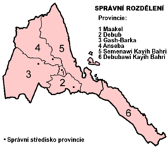
Eritrea Regions Numbered Cs
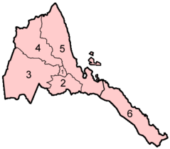
Eritrea Regions Numbered
Eritrea Sm05 Tr
Eritreakaart
Erythree Carte
Flag Map of Eritrea
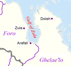
Gulf of Zula
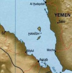
Hanish
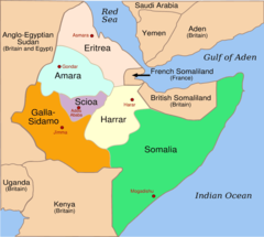
Italian East Africa 1936 1940
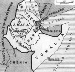
Italian East Africa Map
Mapa Eritreje
Un Eritrea
Eritrea Flag Map