Claremont, California
Claremont: city on the eastern edge of Los Angeles County, California
About
Claremont is a city located in the county of Los Angeles in the U.S. state of California. Its population at the 2010 census was 34,926. After 10 years in 2020 city had an estimated population of 35,096 inhabitants.
The city was created 118 years ago in 1907.

Quick Facts about Claremont
| Population | 35,096 (2020) |
| Country | United States of America |
| State | California (United States) |
| County | Los Angeles County |
| Postal code | 91711 |
| Phone Area Codes | 909 |
| Water as percent of area | 1.03% |
| Land as percent of area | 98.97% |
| Latitude & Longitude | 34.0967,-117.7198 |
| Named for | Claremont |
| Altitude | 3,832 feet / 1168 meters |
| Establishment | October 03, 1907 (118 years ago) |
| Time Zone | Pacific Time Zone, UTC−08:00, UTC−07:00 |
| Local time | 18:36:31 (9th June 2026) |
| Population growth | 0.48% (2010-2020) |
| Weather | 57℉ Partly Cloudy 7-days weather |
Geography
Claremont is located at 34°5'48"N 117°43'11"W (34.0966800, -117.7197800). It has 5 neighbors: La Verne, Montclair, Pomona, San Antonio Heights and Upland.
Claremont map
Weather
Partly cloudy, with a low around 57. West southwest wind 0 to 10 mph.
7-Day ForecastOfficial website of Claremont
Official WebsiteDemographics
The population of Claremont increased by 0.48% in 10 years.
| Year | Population | % Change | Method |
|---|---|---|---|
| 2010 | 34,926 | - | census |
| 2011 | 35,190 | 0.75% | estimation process |
| 2012 | 35,281 | 0.26% | estimation process |
| 2013 | 35,650 | 1.04% | estimation process |
| 2014 | 35,715 | 0.18% | estimation process |
| 2015 | 35,962 | 0.69% | estimation process |
| 2016 | 35,889 | -0.2% | estimation process |
| 2017 | 35,835 | -0.15% | estimation process |
| 2018 | 36,370 | 1.47% | estimation process |
| 2019 | 36,266 | -0.29% | estimation process |
| 2020 | 35,096 | -3.33% | estimation process |
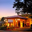
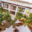
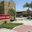
Where to Stay in Claremont
1DoubleTree by Hilton Hotel Claremont
555 W Foothill Blvd, Claremont, CA 91711, United States View details
Phone: +19096262411 | Website available
2Motel 6 Claremont, CA
840 S Indian Hill Blvd, Claremont, CA 91711, United States View details
Phone: +19096214831 | Website available
3Hotel Casa 425 + Lounge
425 W 1st St, Claremont, CA 91711, United States View details
Phone: +19096242272 | Website available
4Claremont Lodge
736 S Indian Hill Blvd, Claremont, CA 91711, United States View details
Phone: +19096265654 | Website available
5Knights Inn Claremont
721 S Indian Hill Blvd, Claremont, CA 91711, United States View details
Phone: +19096262431 | Website available

People born in Claremont (20)
People born in Claremont, including composer, lyricist, record producer, and playwright Jim Steinman, racing cyclist Evelyn Stevens, film editor Elliot Graham, .
More notable people
- Frederick Sumner Brackett (American physicist) he was born in 01/08/1896
- Glenn Davis (American football player and Heisman Trophy winner (1924-2005)) he was born in 26/12/1924
- Cameron Munter (American diplomat) he was born in 16/04/1954
- Alex Hinshaw (American baseball pitcher) he was born in 31/10/1982
- Conner Henry (American basketball player-coach) he was born in 21/07/1963
- Heather Ann Davis (American actress) she was born in 27/11/1984
- Anastasia Horne (American actress) she was born in 05/08/1978
- Ryan Thomas (American soccer player) he was born in 20/03/1989
- Tony Beltran (American soccer player) he was born in 11/10/1987
- Jessica Fisher (American poet) she was born in 12/03/1976
- Kori Carter (American hurdler) she was born in 03/06/1992
- Bill Walkenbach (American baseball coach) he was born in 01/01/2000
- Raja Kumari (Indian American Rapper) she was born in 11/01/1986
- Griffin Easter (Road bicycle racer) he was born in 06/11/1991
- Tyler Hilinski (American football quarterback (1996-2018)) he was born in 26/05/1996
- Stephanie Allynne (American actress) she was born in 19/09/1986
- Nancy Sanford Hughes she was born in 08/01/1943
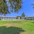
Nearby Schools and Colleges
Schools and campuses linked to Claremont, CA. Select a name to open its map and contact details.
| Code | Name | City | ZIP |
|---|---|---|---|
| 488387 | Claremont Lincoln University | Claremont (CA) | 91711-4744 |
| 112251 | Claremont Graduate University | Claremont (CA) | 91711-6160 |
| 112260 | Claremont McKenna College | Claremont (CA) | 91711-6400 |
| 115409 | Harvey Mudd College | Claremont (CA) | 91711 |
| 121257 | Pitzer College | Claremont (CA) | 91711-6101 |
Nearby Transit Stations (49)
Rail and bus stations connected to Claremont, CA. Select a station to open its map and address details.
| Code | Name | Address | Type |
|---|---|---|---|
| CLM | Claremont, California | 200 West First St. | BUS |
| POS | Pomona station | 100 West Commercial Street | RAIL |
| ONA | Ontario | 228 South Plum Street | RAIL |
| FUL | Fullerton Transportation Center | 120 East Santa Fe Avenue | RAIL |
| RIV | Riverside–Downtown | 4066 Vine St. | RAIL |
Other places with the same name (6)
- Claremont, New Hampshire city in New Hampshire, United States with a population of 12,944 people.
- Claremont, North Carolina city in North Carolina, United States with a population of 1,414 people.
- Claremont, Minnesota city in Minnesota, United States with a population of 477 people.
- Claremont, Virginia town in Virginia, United States with a population of 335 people.
- Claremont, Illinois village in Richland County, Illinois, United States with a population of 168 people.
- Claremont, South Dakota town in Brown County, South Dakota, United States with a population of 122 people.
Other cities in Los Angeles County
Cities, towns, neighborhoods & other populated places in Los Angeles County , CA. (more)
| City Name | Population | Title |
|---|---|---|
| Los Angeles | 3,970,219 | The second most populous city in the United States and the center of the Los Angeles metropolitan area. |
| Long Beach | 454,681 | The second most populous city in California, Long Beach is a major center for business, manufacturing, and tourism. |
| Santa Clarita | 209,990 | The second most populous city in Los Angeles County, California. |
| Glendale | 197,747 | The second most populous city in Los Angeles County, California. |
| Lancaster | 155,822 | The most populous city in Los Angeles County, California. |
| Palmdale | 150,498 | The most populous city in Los Angeles County, California. |
| Pomona | 149,212 | The sixth most populous city in Los Angeles County, California. |
| Torrance | 141,553 | The third most populous city in Los Angeles County, California. |
| Pasadena | 141,045 | The second most populous city in Los Angeles County, California. |
| East Los Angeles | 126,496 | Census-designated place in Los Angeles County, California, United States |
| El Monte | 112,344 | The most populous city in Los Angeles County, California. |
| Downey | 109,202 | The most populous city in Los Angeles County, California. |
| Inglewood | 107,203 | The most populous city in Los Angeles County, California. |
| Santa Maria | 105,851 | The third most populous city in Santa Barbara County, California. |
| West Covina | 103,656 | The most populous city in Los Angeles County, California. |
| Norwalk | 102,635 | The most populous city in Los Angeles County, California. |
Distance to Other Cities
Claremont distances to largest California cities