Cape Canaveral Air Force Station, Florida
Cape Canaveral Air Force Station: spaceport on Cape Canaveral, Florida
About
Cape Canaveral Air Force Station is a place located in the county of Brevard in the U.S. state of Florida.
Quick Facts about Cape Canaveral Air Force Station
| Country | United States of America |
| State | Florida (United States) |
| County | Brevard County |
| Different from | Kennedy Space Center |
| Latitude & Longitude | 28.4676,-80.5669 |
| Time Zone | America/New_York |
| Local time | 01:42:30 (11th June 2026) |
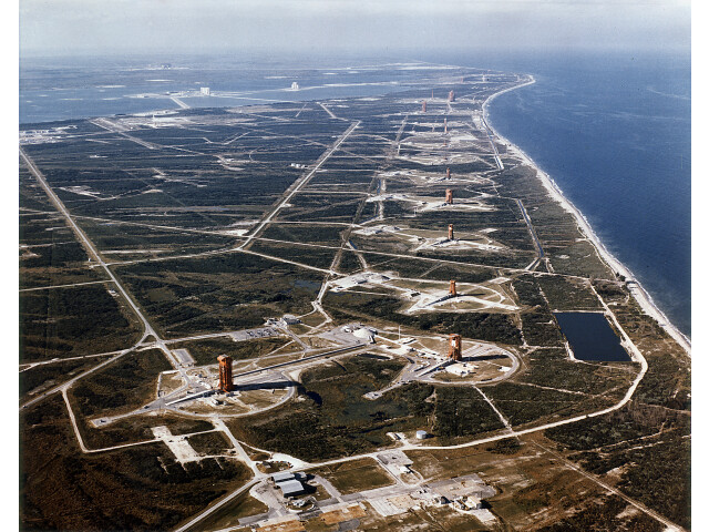
Aerial View of Missile Row - GPN-2000-000610 image
Geography
Cape Canaveral Air Force Station is located at 28°28'3"N 80°34'1"W (28.4676300, -80.5668600).
Cape Canaveral Air Force Station map
Click "full screen"  icon to open full mode. View satellite images
Official website of Cape Canaveral Air Force Station
Official Website
Base de lancement de Cap Canaveral, Baza VPS SShA na misi Kanaveral, Baza VPS ZShA na myse Kanaveral, Baza VVS SShA na myse Kanaveral, Cabo Canaveral, Cabo Cañaveral, Cape Canaveral Hava Kuvvetleri UEssue, Cape Canaveral Hava Kuvvetleri Üssü, Cape Canaveral flystasjon, Estacao da Forca Aerea de Cabo Canaveral, Estacion de la Fuerza Aerea de Cabo Canaveral, Estación de la Fuerza Aérea de Cabo Cañaveral, Estação da Força Aérea de Cabo Canaveral, Kanaveralas zemesraga Gaisa speku stacija, Kanaveralas zemesraga Gaisa spēku stacija, Keip Kanaveral, Kejp Kanaveral, Tram khong quan Mui Canaveral, ka na wei la er jiao kong jun ji de, keipeukeonaebeoleol gong-gun giji, kepukanaberaru kong jun ji de, nml hhll qyyp qnwwrl, paygah nyrwy hwayy kyp kanawral, Κέιπ Κανάβεραλ, База ВВС США на мысе Канаверал, База ВПС ЗША на мысе Канаверал, База ВПС США на мисі Канаверал, Кейп Канаверал, נמל החלל קייפ קנוורל, قاعدة كيب كانافيرال للقوات الجوية, پایگاه نیروی هوایی کیپ کاناورال, ケープカナベラル空軍基地, 卡纳维拉尔角空军基地, 케이프커내버럴 공군 기지
People born in Cape Canaveral Air Force Station (1)
American basketball coach Billy Kennedy was born in Cape Canaveral Air Force Station