Cape Breton Island, Nova Scotia
Cape Breton Island: Island in Nova Scotia, Canada
About
Quick Facts about Cape Breton Island
| Country | Canada |
| State | Nova Scotia (Canada) |
| Different from | Capbreton |
| Area | 10311 km2 |
| Continent | North America |
| Latitude & Longitude | 46.1668,-60.7485 |
| Altitude | 1,745 feet / 532 meters |
| Capital | Sydney |
| Time Zone | UTC−04:00 |
| Local time | 09:27:51 (1st July 2026) |
Geography
Cape Breton Island is located at 46°10'1"N 60°44'55"W (46.166839974, -60.748486726).
Cape Breton Island map
Click "full screen"  icon to open full mode. View satellite images
Cape Breton, Cape Breton-eiland, Eilean Cheap Bhreatainn, Ile du Cap-Breton, Ilha Cape Breton, Insulo de Breton-Kabo, Isla de Cabo Breton, Isla de Cabo Bretón, Kap Bretonoen, Kap Bretonön, Kap-Breton-Insel, Île du Cap-Breton, ケープブレトン島
Map & Images (more maps)
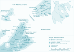
Cape Breton Island Map
1180 x 825
- 65,765k -
png