Canada, CA
Canada: This North American country, with Ottawa as its capital, is the second-largest in the world by area, covering 9, 984, 670 km².
About

Country Snapshot
Canada at a glance
Canada currently has 505 quality-checked populated place pages and 13 state or regional pages linked on MapSof.
Mapped cities & towns
505
These counts use a stricter populated-place filter so the main lists stay focused on real city and town pages.
States & regions
13
Open related pagesLargest city
VictoriaPopulation 6,689,377
Top linked places
Quick Facts about Canada
| Population | 41,651,653 |
| Country | Canada |
| Twitter username | Canada, AuCanada |
| Plate code | CDN |
| Area | 9984670 km2 |
| Official name | Canada, Canada, le Canada |
| Water as percent of area | 8.62% |
| Land as percent of area | 91.38% |
| Continent | North America |
| Easternmost point | Point(-52.619444444 47.523611111) |
| Northernmost point | Point(-69.958333333 83.111388888) |
| Latitude & Longitude | 60.0000,-96.0000 |
| Patron saint | Jean de Brébeuf, North American Martyrs, Saint Anne, Joseph |
| Legislative body | Parliament of Canada |
| Named for | Stadacona |
| Official language | French, English |
| Capital | Ottawa |
| Establishment | July 01, 1867 (158 years ago) |
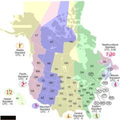
| Time Zone | Mountain Time Zone, Newfoundland Time Zone, UTC−05:00, UTC−07:00, Atlantic Time Zone, Pacific Time Zone, UTC−06:00, UTC−04:00, Eastern Time Zone, Central Time Zone |
| Local time | 21:00:29 (8th June 2026) |

Geography
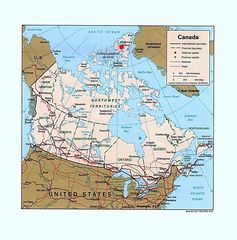
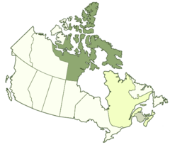
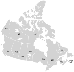
Canada is located at 60°0'0"N 96°0'0"W (60.0, -96.0). It has 4 neighbors: Saint Pierre and Miquelon, Greenland, Prince Edward Island and United States.
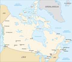
Canada map
The largest city of Canada is Calgary with a population of 1,239,220. Other cities include, Ottawa population 812,129, Hamilton population 536,917, Oshawa population 308,875 and Saskatoon population 246,376. See all Canada cities & populated places.
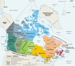
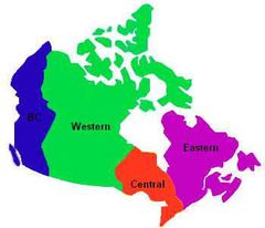
Compare Canada with
- Prince Edward Island
- Manitoba
- Northwest Territories
- Saskatchewan
- British Columbia
- Yukon
- Alberta
- Nunavut
- District of Keewatin
- Newfoundland and Labrador
- Ontario
- Quebec
- New Brunswick
- Nova Scotia
Demographics
| Year | Population | % Change | Method |
|---|---|---|---|
| 1605 | 44 | - | estimation process |
| 1608 | 28 | -57.14% | estimation process |
| 1620 | 602 | 95.35% | estimation process |
| 1622 | 32 | -1781.25% | estimation process |
| 1628 | 76 | 57.89% | estimation process |
| 1629 | 117 | 35.04% | estimation process |
| 1641 | 240 | 51.25% | estimation process |
| 1663 | 2,500 | 90.4% | estimation process |
| 1666 | 3,215 | 22.24% | 1665-01-01T00:00:00Z |
| 1667 | 3,918 | 17.94% | estimation process |
| 1668 | 6,282 | 37.63% | estimation process |
| 1671 | 514 | -1122.18% | estimation process |
| 1673 | 6,768 | 92.41% | estimation process |
| 1675 | 7,832 | 13.59% | estimation process |
| 1676 | 8,415 | 6.93% | estimation process |
| 1680 | 10,679 | 21.2% | estimation process |
| 1681 | 9,677 | -10.35% | estimation process |
| 1683 | 10,251 | 5.6% | estimation process |
| 1685 | 12,263 | 16.41% | estimation process |
| 1686 | 13,258 | 7.5% | estimation process |
| 1687 | 663 | -1899.7% | estimation process |
| 1691 | 155 | -327.74% | estimation process |
| 1693 | 1,009 | 84.64% | estimation process |
| 1695 | 13,688 | 92.63% | estimation process |
| 1698 | 17,832 | 23.24% | estimation process |
| 1701 | 1,134 | -1472.49% | estimation process |
| 1705 | 520 | -118.08% | estimation process |
| 1706 | 16,417 | 96.83% | estimation process |
| 1707 | 18,688 | 12.15% | estimation process |
| 1711 | 225 | -8205.78% | estimation process |
| 1712 | 18,440 | 98.78% | estimation process |
| 1713 | 18,119 | -1.77% | estimation process |
| 1714 | 20,737 | 12.62% | estimation process |
| 1718 | 22,983 | 9.77% | estimation process |
| 1719 | 22,530 | -2.01% | estimation process |
| 1720 | 24,534 | 8.17% | estimation process |
| 1721 | 24,951 | 1.67% | estimation process |
| 1722 | 25,053 | 0.41% | estimation process |
| 1723 | 26,479 | 5.39% | estimation process |
| 1726 | 29,396 | 9.92% | estimation process |
| 1728 | 330 | -8807.88% | estimation process |
| 1730 | 33,682 | 99.02% | estimation process |
| 1731 | 6,000 | -461.37% | estimation process |
| 1732 | 35,164 | 82.94% | estimation process |
| 1734 | 37,716 | 6.77% | estimation process |
| 1735 | 541 | -6871.53% | estimation process |
| 1736 | 39,063 | 98.62% | estimation process |
| 1739 | 42,817 | 8.77% | estimation process |
| 1753 | 13,000 | -229.36% | estimation process |
| 1760 | 70,000 | 81.43% | estimation process |
| 1763 | 78,880 | 11.26% | estimation process |
| 1764 | 12,998 | -506.86% | estimation process |
| 1765 | 89,749 | 85.52% | estimation process |
| 1767 | 11,779 | -661.94% | estimation process |
| 1771 | 8,442 | -39.53% | estimation process |
| 1772 | 19,985 | 57.76% | estimation process |
| 1775 | 90,000 | 77.79% | estimation process |
| 1781 | 12,000 | -650% | estimation process |
| 1784 | 166,012 | 92.77% | estimation process |
| 1785 | 10,244 | -1520.58% | estimation process |
| 1790 | 191,311 | 94.65% | estimation process |
| 1793 | 2,000 | -9465.55% | 1653-01-01T00:00:00Z |
| 1797 | 4,500 | 55.56% | estimation process |
| 1811 | 77,000 | 94.16% | estimation process |
| 1816 | 52,672 | -46.19% | estimation process |
| 1826 | 166,379 | 68.34% | estimation process |
| 1828 | 246,576 | 32.52% | estimation process |
| 1829 | 197,815 | -24.65% | estimation process |
| 1831 | 792,226 | 75.03% | estimation process |
| 1832 | 322,834 | -145.4% | estimation process |
| 1835 | 351,008 | 8.03% | estimation process |
| 1836 | 447,804 | 21.62% | estimation process |
| 1837 | 597,395 | 25.04% | estimation process |
| 1838 | 605,963 | 1.41% | estimation process |
| 1839 | 409,048 | -48.14% | estimation process |
| 1840 | 593,025 | 31.02% | estimation process |
| 1841 | 502,730 | -17.96% | estimation process |
| 1842 | 487,053 | -3.22% | estimation process |
| 1843 | 5,143 | -9370.21% | estimation process |
| 1845 | 96,295 | 94.66% | estimation process |
| 1857 | 122,638 | 21.48% | estimation process |
| 1861 | 3,229,633 | 96.2% | census |
| 1867 | 3,463,000 | 6.74% | estimation process |
| 1868 | 3,511,000 | 1.37% | estimation process |
| 1870 | 3,625,000 | 3.14% | estimation process |
| 1871 | 3,689,257 | 1.74% | census |
| 1872 | 3,754,000 | 1.72% | estimation process |
| 1873 | 3,826,000 | 1.88% | estimation process |
| 1875 | 3,954,000 | 3.24% | estimation process |
| 1876 | 4,009,000 | 1.37% | estimation process |
| 1878 | 4,120,000 | 2.69% | estimation process |
| 1879 | 4,185,000 | 1.55% | estimation process |
| 1881 | 4,325,000 | 3.24% | estimation process |
| 1882 | 4,375,000 | 1.14% | estimation process |
| 1883 | 4,430,000 | 1.24% | estimation process |
| 1884 | 4,487,000 | 1.27% | estimation process |
| 1885 | 4,537,000 | 1.1% | estimation process |
| 1886 | 4,580,000 | 0.94% | estimation process |
| 1887 | 4,626,000 | 0.99% | estimation process |
| 1888 | 4,678,000 | 1.11% | estimation process |
| 1890 | 4,779,000 | 2.11% | estimation process |
| 1891 | 4,833,239 | 1.12% | census |
| 1892 | 4,883,000 | 1.02% | estimation process |
| 1895 | 5,026,000 | 2.85% | estimation process |
| 1896 | 5,074,000 | 0.95% | estimation process |
| 1897 | 5,122,000 | 0.94% | estimation process |
| 1898 | 5,175,000 | 1.02% | estimation process |
| 1900 | 5,301,000 | 2.38% | estimation process |
| 1901 | 5,371,315 | 1.31% | census |
| 1902 | 5,494,000 | 2.23% | estimation process |
| 1904 | 5,827,000 | 5.71% | estimation process |
| 1905 | 6,002,000 | 2.92% | estimation process |
| 1906 | 6,097,000 | 1.56% | estimation process |
| 1907 | 6,411,000 | 4.9% | estimation process |
| 1909 | 6,800,000 | 5.72% | estimation process |
| 1911 | 7,207,000 | 5.65% | estimation process |
| 1912 | 7,389,000 | 2.46% | estimation process |
| 1913 | 7,632,000 | 3.18% | estimation process |
| 1914 | 7,879,000 | 3.13% | estimation process |
| 1916 | 8,001,000 | 1.52% | estimation process |
| 1917 | 8,060,000 | 0.73% | estimation process |
| 1918 | 8,148,000 | 1.08% | estimation process |
| 1919 | 8,311,000 | 1.96% | estimation process |
| 1920 | 8,556,000 | 2.86% | estimation process |
| 1921 | 8,787,949 | 2.64% | census |
| 1922 | 8,919,000 | 1.47% | estimation process |
| 1924 | 9,143,000 | 2.45% | estimation process |
| 1925 | 9,294,000 | 1.62% | estimation process |
| 1927 | 9,637,000 | 3.56% | estimation process |
| 1928 | 9,835,000 | 2.01% | estimation process |
| 1929 | 10,029,000 | 1.93% | estimation process |
| 1930 | 10,208,000 | 1.75% | estimation process |
| 1931 | 10,376,786 | 1.63% | census |
| 1933 | 10,633,000 | 2.41% | estimation process |
| 1934 | 10,741,000 | 1.01% | estimation process |
| 1936 | 10,950,000 | 1.91% | estimation process |
| 1937 | 11,045,000 | 0.86% | estimation process |
| 1939 | 11,267,000 | 1.97% | estimation process |
| 1940 | 11,381,000 | 1% | estimation process |
| 1941 | 11,507,000 | 1.09% | estimation process |
| 1942 | 11,654,000 | 1.26% | estimation process |
| 1943 | 11,795,000 | 1.2% | estimation process |
| 1944 | 11,946,000 | 1.26% | estimation process |
| 1945 | 12,072,000 | 1.04% | estimation process |
| 1946 | 12,292,000 | 1.79% | estimation process |
| 1947 | 12,551,000 | 2.06% | estimation process |
| 1948 | 12,823,000 | 2.12% | estimation process |
| 1949 | 13,447,000 | 4.64% | estimation process |
| 1950 | 13,712,000 | 1.93% | estimation process |
| 1951 | 14,009,000 | 2.12% | estimation process |
| 1952 | 14,459,000 | 3.11% | estimation process |
| 1953 | 14,845,000 | 2.6% | estimation process |
| 1955 | 15,698,000 | 5.43% | estimation process |
| 1956 | 16,081,000 | 2.38% | estimation process |
| 1957 | 16,610,000 | 3.18% | estimation process |
| 1958 | 17,080,000 | 2.75% | estimation process |
| 1959 | 17,483,000 | 2.31% | estimation process |
| 1960 | 17,909,009 | 2.38% | estimation process |
| 1961 | 18,238,000 | 1.8% | estimation process |
| 1962 | 18,614,000 | 2.02% | estimation process |
| 1963 | 18,964,000 | 1.85% | estimation process |
| 1964 | 19,325,000 | 1.87% | estimation process |
| 1965 | 19,678,000 | 1.79% | estimation process |
| 1966 | 20,015,000 | 1.68% | estimation process |
| 1967 | 20,412,000 | 1.94% | estimation process |
| 1968 | 20,701,000 | 1.4% | estimation process |
| 1969 | 21,001,000 | 1.43% | estimation process |
| 1970 | 21,324,000 | 1.51% | estimation process |
| 1971 | 21,961,999 | 2.91% | estimation process |
| 1972 | 21,993,631 | 0.14% | 1823-01-01T00:00:00Z |
| 1973 | 22,491,757 | 2.21% | estimation process |
| 1974 | 22,807,918 | 1.39% | estimation process |
| 1975 | 23,143,192 | 1.45% | estimation process |
| 1976 | 23,449,791 | 1.31% | estimation process |
| 1977 | 23,796,000 | 1.45% | estimation process |
| 1978 | 23,963,370 | 0.7% | estimation process |
| 1979 | 24,277,000 | 1.29% | estimation process |
| 1980 | 24,516,071 | 0.98% | estimation process |
| 1981 | 24,900,000 | 1.54% | estimation process |
| 1982 | 25,202,000 | 1.2% | estimation process |
| 1983 | 25,456,000 | 1% | estimation process |
| 1984 | 25,607,651 | 0.59% | estimation process |
| 1985 | 25,842,736 | 0.91% | estimation process |
| 1986 | 26,204,000 | 1.38% | estimation process |
| 1987 | 26,550,000 | 1.3% | estimation process |
| 1988 | 26,895,000 | 1.28% | estimation process |
| 1989 | 27,281,795 | 1.42% | estimation process |
| 1990 | 27,791,000 | 1.83% | estimation process |
| 1991 | 28,171,682 | 1.35% | estimation process |
| 1992 | 28,519,597 | 1.22% | 1935-01-01T00:00:00Z |
| 1993 | 28,833,410 | 1.09% | 1990-01-01T00:00:00Z |
| 1994 | 28,999,006 | 0.57% | estimation process |
| 1995 | 29,302,091 | 1.03% | estimation process |
| 1996 | 29,671,900 | 1.25% | estimation process |
| 1997 | 29,987,200 | 1.05% | 1724-01-01T00:00:00Z |
| 1998 | 30,247,900 | 0.86% | estimation process |
| 1999 | 30,499,200 | 0.82% | estimation process |
| 2000 | 30,769,700 | 0.88% | estimation process |
| 2001 | 31,021,251 | 0.81% | estimation process |
| 2002 | 31,362,000 | 1.09% | estimation process |
| 2003 | 31,676,077 | 0.99% | estimation process |
| 2004 | 31,989,454 | 0.98% | estimation process |
| 2005 | 32,299,496 | 0.96% | estimation process |
| 2006 | 32,623,490 | 0.99% | estimation process |
| 2007 | 32,887,928 | 0.8% | estimation process |
| 2008 | 33,245,773 | 1.08% | estimation process |
| 2009 | 33,628,571 | 1.14% | estimation process |
| 2010 | 34,005,274 | 1.11% | estimation process |
| 2011 | 34,342,780 | 0.98% | estimation process |
| 2012 | 34,752,128 | 1.18% | estimation process |
| 2013 | 35,154,279 | 1.14% | estimation process |
| 2014 | 35,437,435 | 0.8% | (Worldbank) |
| 2015 | 35,702,707 | 0.74% | estimation process |
| 2016 | 36,155,487 | 1.25% | 1987-01-01T00:00:00Z |
| 2017 | 36,708,083 | 1.51% | 1962-01-01T00:00:00Z |
| 2018 | 37,057,765 | 0.94% | (Worldbank) |
| 2019 | 37,589,262 | 1.41% | (Worldbank) |
| 2026 | 41,651,653 | 9.75% |
Map & Images (more maps)
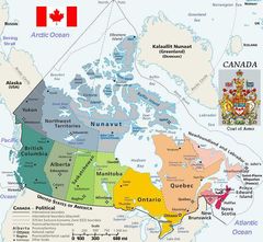
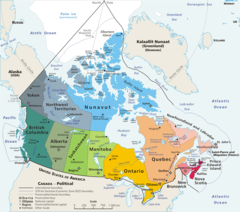
Map Canada Political
2007 Fifa U 20 World Cup Venues
Abortionaccessincanadamap Englishlegend
Abortionaccessincanadamap
Alaskahwy Canadamap
Cis Football Locations
Cuc Regions Map
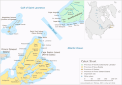
Cabot Strait
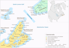
Cabotstrasse
Canada (geolocalisation)
Canada Kosovo Locator 1
Canada Usa Time

Canada Blank Map

Canada Contour Flag
Canada Geo Hsi
Canada Geopolitical Map Trim
Canada Geopolitical
Canada Labelled Map
Canada Lower
Canada Map (lt)