Arkansas, US
Arkansas: Located in the southeastern region of the United States, this state is known for its diverse landscapes, including the Ozark Mountains and the Mississippi River Delta.
About
Arkansas became the 25th state admitted to the Union on June 15, 1836. Its capital and most populous city is Little Rock. Arkansas is known as the Natural State for its abundant natural scenic beauty and resources.
Geography and Climate
Arkansas has a total area of 53,179 square miles. It shares borders with 6 states: Mississippi, Tennessee, Missouri, Oklahoma, Texas, and Louisiana. The geography consists of mountains, hills, plains, and fertile delta. Major rivers include the Mississippi River and Arkansas River.
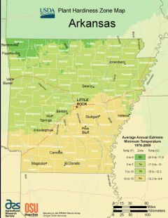
Arkansas has a humid subtropical climate with hot humid summers and mild winters. The state experiences all four seasons.
Economy and Industries
Key Arkansas industries include agriculture, food processing, technology, and tourism. Top agricultural products are soybeans, chickens, cattle, and rice. Major companies headquartered in the state are Walmart, Tyson Foods and J.B. Hunt. Tourism draws visitors to spots like Hot Springs National Park.
Culture and Demographics
Arkansas has about 3 million residents. The largest ethnicity is white at 73% followed by African American at 15%. The culture reflects traditional southern hospitality mixed with Ozark and Ouachita Mountain influences. Bentonville is emerging as an art and culture hub.
Education and Sports
The University of Arkansas flagship campus is located in Fayetteville. Other major schools include Arkansas State University and University of Central Arkansas. No major pro sports teams are based in Arkansas. The Razorbacks college football team has a passionate fan base.
Government and Politics
The current governor is Asa Hutchinson, a Republican first elected in 2014. Arkansas has an overall conservative political landscape. It has voted for Republican presidential candidates since 2000.
Conclusion
In summary, Arkansas is filled with natural scenic beauty and homegrown companies like Walmart and Tyson Foods. It has a large agricultural industry and distinctive southern culture. Natural resources and a low cost of living attract residents and tourists alike.

State Snapshot
Arkansas at a glance
Arkansas currently has 521 quality-checked populated place pages and 75 county pages linked on MapSof.
Mapped cities & towns
521
These counts use a stricter populated-place filter so the main lists stay focused on real city and town pages.
County pages
75
Open related pagesLargest city
Little RockPopulation 197,866
Top linked places
Quick Facts about Arkansas
| Population | 0 |
| Country | United States of America |
| Different from | Arkansas |
| Area | 137733 km2 |
| Water as percent of area | 2.15% |
| Land as percent of area | 97.85% |
| Northernmost point | Point(-94.3549 36.4998) |
| Latitude & Longitude | 34.7504,-92.5004 |
| Legislative body | Arkansas General Assembly |
| Named for | Quapaw |
| Official language | English |
| Altitude | 650 feet / 198 meters |
| Capital | Little Rock |
| Establishment | June 15, 1836 (190 years ago) |
| Time Zone | America/Chicago, UTC−06:00, Central Time Zone |
| Local time | 20:02:55 (22nd July 2026) |
| Weather | 95℉ Sunny 7-days weather |

Geography
Arkansas is located at 34°45'1"N 92°30'2"W (34.7503700, -92.5004400). It has 6 neighbors: Louisiana, Missouri, Mississippi, Oklahoma, Tennessee and Texas.
Arkansas map
The largest city of Arkansas is Little Rock with a population of 197,866. Other cities include, Fayetteville population 89,576, Fort Smith population 87,764, Springdale population 81,115 and Jonesboro population 79,859. See all Arkansas cities & populated places.
Largest Cities in Arkansas (more)
Cities, Towns, Villages, Neighborhoods & Other Populated Places in Arkansas.
| City Name | County | Population |
|---|---|---|
| Little Rock | Pulaski | 197,866 |
| Fayetteville | Washington | 89,576 |
| Fort Smith | Sebastian | 87,764 |
| Springdale | Washington | 81,115 |
| Jonesboro | Craighead | 79,859 |
| Rogers | Benton | 70,522 |
| Conway | Faulkner | 68,100 |
| North Little Rock | Pulaski | 66,276 |
| Bentonville | Benton | 57,537 |
| Pine Bluff | Jefferson | 40,435 |
| Hot Springs | Garland | 38,939 |
| Benton | Saline | 37,214 |
| Sherwood | Pulaski | 31,653 |
| Texarkana | Miller | 29,556 |
| Bella Vista | Benton | 29,423 |
| Russellville | Pope | 29,364 |
Show more Arkansas cities and populated places
Official website of Arkansas
Official Website- Desha County
- Lonoke County
- Madison County
- Sevier County
- Hempstead County
- Saline County
- Cross County
- Hot Spring County
- Independence County
- Sharp County
- Cleburne County
- Yell County
- Scott County
- Pulaski County
- Howard County
- Grant County
- Garland County
- Crawford County
- Izard County
- Sebastian County
- Pike County
- Craighead County
- Newton County
- Washington County
- Benton County
- Randolph County
- Pope County
- Marion County
- Montgomery County
- Dallas County
- St. Francis County
- Clark County
- Drew County
- Faulkner County
- Clay County
- Lincoln County
- Stone County
- Phillips County
- Van Buren County
- Mississippi County
- Johnson County
- Cleveland County
- Chicot County
- Lawrence County
- Columbia County
- Conway County
- Prairie County
- Logan County
- Ouachita County
- Lafayette County
- Perry County
- Little River County
- Miller County
- White County
- Greene County
- Boone County
- Lee County
- Jefferson County
- Woodruff County
- Monroe County
- Arkansas County
- Ashley County
- Calhoun County
- Jackson County
- Baxter County
- Union County
- Franklin County
- Crittenden County
- Searcy County
- Carroll County
- Fulton County
- Poinsett County
- Nevada County
- Bradley County
- Polk County
Demographics
| Year | Population | % Change | Method |
|---|---|---|---|
| 1910 | 1,574,449 | - | census |
| 1920 | 1,752,204 | 10.14% | census |
| 1930 | 1,854,482 | 5.52% | census |
| 1940 | 1,949,387 | 4.87% | census |
| 1950 | 1,909,511 | -2.09% | census |
| 1960 | 1,786,272 | -6.9% | census |
| 1970 | 1,923,295 | 7.12% | census |
| 1980 | 2,286,435 | 15.88% | census |
| 1990 | 2,350,725 | 2.73% | census |
| 2000 | 2,673,400 | 12.07% | census |
| 2010 | 2,915,918 | 8.32% | census |
| 2011 | 2,940,667 | 0.84% | estimation process |
| 2012 | 2,952,164 | 0.39% | estimation process |
| 2013 | 2,959,400 | 0.24% | estimation process |
| 2014 | 2,967,392 | 0.27% | estimation process |
| 2015 | 2,978,048 | 0.36% | estimation process |
| 2016 | 2,989,918 | 0.4% | estimation process |
| 2017 | 3,001,345 | 0.38% | estimation process |
| 2018 | 3,009,733 | 0.28% | estimation process |
| 2019 | 3,017,804 | 0.27% | estimation process |
| 2020 | 3,030,522 | 0.42% | estimation process |
| 2026 | 340,110,988 | 99.11% |
People born in Arkansas (150)
People born in Arkansas, including racing driver Jim Rigsby, baseball player George Kell, blues musician Roosevelt Sykes, .
More notable people
- Jimmy Driftwood (singer) he was born in 20/06/1907
- Sonny Burgess (American rockabilly guitarist and singer) he was born in 28/05/1931
- Joe Perry (Player of American football (1927-2011)) he was born in 22/01/1927
- Dave Wasson (American television producer) he was born in 01/01/2000
- Louis Jordan (American jazz, blues and rhythm and blues musician, songwriter and bandleader (1908-1975)) he was born in 08/07/1908
- Luenell (American comedian and actress) she was born in 12/03/1959
- Willie Cobbs (American blues singer and harmonica player) he was born in 15/07/1932
- Bert Layne (American musician) he was born in 14/12/1889
- Bill Dowdy (American musician) he was born in 15/08/1932
- Blind Joe Reynolds (American musician) he was born in 01/01/1900
- Blue Steele (American musician and bandleader) he was born in 11/03/1893
- Bob Dorough (American pianist and singer) he was born in 12/12/1923
- John P. McConnell (American Air Force general) he was born in 07/02/1908
- Chuck Comer (American musician) he was born in 27/07/1934
- David E. Finley (American politician (1861-1917)) he was born in 28/02/1861
- Kenny Owens (American musician) he was born in 01/01/2000
- Joe Purdy (American musician) he was born in 01/01/2000
- Lymon C. Reese (American university teacher (1917-2009)) he was born in 27/04/1917
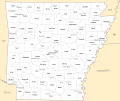
Arkansas Counties (more)
Pulaski County

county in Arkansas, United States
Benton County

county in Arkansas, United States
Washington County

county in Arkansas, United States
| County Name | Population |
|---|---|
| Pulaski County | 392,980 |
| Benton County | 288,774 |
| Washington County | 243,216 |
| Sebastian County | 127,590 |
| Faulkner County | 126,919 |
| Saline County | 123,968 |
| Craighead County | 112,245 |
| Garland County | 99,789 |
| White County | 78,729 |
| Lonoke County | 73,921 |
| Jefferson County | 65,377 |
| Pope County | 64,334 |
| Crawford County | 63,409 |
| Crittenden County | 47,616 |
| Greene County | 45,597 |
| Miller County | 43,177 |
Show more Arkansas counties
Map & Images (more maps)
Arkansas Flag Map
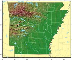
Arkansas Relief Map
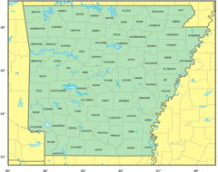
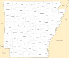
Counties Location Map of Arkansas
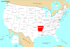
Where Is Arkansas Located
Arkansas Cities And Towns
Arkansas County Map
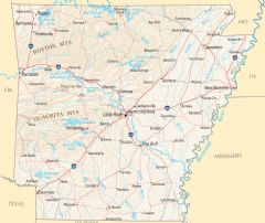
Arkansas Reference Map
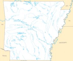
Arkansas Rivers And Lakes