Anguilla, AI
Anguilla: British Overseas Territory in the Caribbean
About

Country Snapshot
Anguilla at a glance
Anguilla currently has 1 quality-checked populated place pages and 0 state or regional pages linked on MapSof.
Mapped cities & towns
1
These counts use a stricter populated-place filter so the main lists stay focused on real city and town pages.
States & regions
0
Open related pagesLargest city
The ValleyPopulation 2,035
Top linked places
Quick Facts about Anguilla
| Population | 16,010 |
| Country | United Kingdom |
| Different from | Anguilla |
| Area | 91 km2 |
| Official name | Anguilla |
| Continent | North America |
| Latitude & Longitude | 18.2167,-63.0500 |
| Legislative body | Anguilla House of Assembly |
| Official language | English |
| Capital | The Valley |
| Time Zone | UTC−04:00 |
| Local time | 02:47:10 (19th July 2026) |
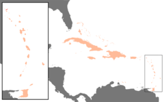
Anguilla on the globe 'Americas centered' locator map image
Geography
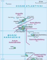
Anguilla is located at 18°13'0"N 63°3'0"W (18.2166700, -63.0500000).
Anguilla map
Click "full screen"  icon to open full mode. View satellite images
The largest city of Anguilla is The Valley with a population of 2,035. . See all Anguilla cities & populated places.
Demographics
| Year | Population | % Change | Method |
|---|---|---|---|
| 2026 | 16,010 | - |
An'nkouila, Angil'ja, Angila, Angilija, Angilja, Angiya, Angiye, Angiyɛ, Anguila, Anguilla nutome, Angvila, Angvilla, Angvilo, Angwila, Angwilla, Angûîla, Anikuila, Anngiyaa, Anquila, Orileede Aangulila, Orílẹ́ède Ààngúlílà, aeng-gwilla, amgvila, an gui la, angavilla, anghwyla, angilla, angira, angu'ila, angu'illa, anguyilla, angwyyla, angyl, ankuyla, engu'ila, engvila, i-Anguilla, Ανγκουίλα, Ангвила, Ангилья, Ангуила, Ангуілля, Ангілья, אנגילה, آنگیل, أنغويلا, انگوئیلا, अँग्विला, आङ्गुइला, एंगुइला, এ্যাঙ্গুইলা, ઍંગ્વિલા, ଆଙ୍ଗୁଇଲ୍ଲା, அங்குய்லா, ఆంగవిల్లా, ಆಂಗುಯಿಲ್ಲಾ, ആന്ഗ്വില്ല, ඇන්ගුයිලාව, แองกวิลลา, ອັນກິລາ, ཨང་གུའི་ལ།, အန်ကွီလာ, ანგვილა, አንጉኢላ, アンギラ, 安圭拉, 안길라, 앵귈라
Map & Images (more maps)
Karibik Anguilla Position
1024 x 636
- 15,637k -
png
Saint Martin Map
527 x 678
- 23,098k -
png