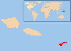
American Samoa, AS
American Samoa:
About
Country Snapshot
American Samoa at a glance
American Samoa currently has 9 quality-checked populated place pages and 2 state or regional pages linked on MapSof.
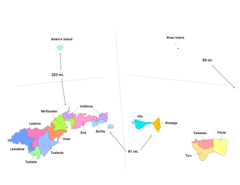
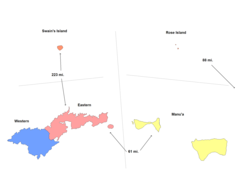
Mapped cities & towns
9
These counts use a stricter populated-place filter so the main lists stay focused on real city and town pages.
States & regions
2
Open related pagesLargest city
Pago PagoPopulation 11,500
Top linked places
Quick Facts about American Samoa
| Population | 49,710 |
| Latitude & Longitude | -14.2338,-169.4777 |
| Time Zone | Pacific/Pago_Pago |
| Local time | 08:50:39 (9th June 2026) |
Geography
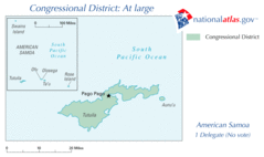
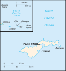
American Samoa is located at 14°14'2"S 169°28'40"W (-14.2337700, -169.4776700).
American Samoa map
Click "full screen"  icon to open full mode. View satellite images
The largest city of American Samoa is Pago Pago with a population of 11,500. . See all American Samoa cities & populated places.
Demographics
| Year | Population | % Change | Method |
|---|---|---|---|
| 1960 | 20,123 | - | |
| 1961 | 20,602 | 2.33% | |
| 1962 | 21,253 | 3.06% | |
| 1963 | 22,034 | 3.54% | |
| 1964 | 22,854 | 3.59% | |
| 1965 | 23,672 | 3.46% | |
| 1966 | 24,462 | 3.23% | |
| 1967 | 25,248 | 3.11% | |
| 1968 | 25,989 | 2.85% | |
| 1969 | 26,703 | 2.67% | |
| 1970 | 27,363 | 2.41% | |
| 1971 | 27,984 | 2.22% | |
| 1972 | 28,567 | 2.04% | |
| 1973 | 29,100 | 1.83% | |
| 1974 | 29,596 | 1.68% | |
| 1975 | 30,052 | 1.52% | |
| 1976 | 30,456 | 1.33% | |
| 1977 | 30,838 | 1.24% | |
| 1978 | 31,269 | 1.38% | |
| 1979 | 31,845 | 1.81% | |
| 1980 | 32,646 | 2.45% | |
| 1981 | 33,701 | 3.13% | |
| 1982 | 34,968 | 3.62% | |
| 1983 | 36,412 | 3.97% | |
| 1984 | 37,946 | 4.04% | |
| 1985 | 39,519 | 3.98% | |
| 1986 | 41,119 | 3.89% | |
| 1987 | 42,740 | 3.79% | |
| 1988 | 44,343 | 3.62% | |
| 1989 | 45,894 | 3.38% | |
| 1990 | 47,347 | 3.07% | |
| 1991 | 48,685 | 2.75% | |
| 1992 | 49,896 | 2.43% | |
| 1993 | 51,020 | 2.2% | |
| 1994 | 52,095 | 2.06% | |
| 1995 | 53,161 | 2.01% | |
| 1996 | 54,211 | 1.94% | |
| 1997 | 55,221 | 1.83% | |
| 1998 | 56,171 | 1.69% | |
| 1999 | 57,053 | 1.55% | |
| 2000 | 57,821 | 1.33% | |
| 2001 | 58,494 | 1.15% | |
| 2002 | 59,080 | 0.99% | |
| 2003 | 59,504 | 0.71% | |
| 2004 | 59,681 | 0.3% | |
| 2005 | 59,562 | -0.2% | |
| 2006 | 59,107 | -0.77% | |
| 2007 | 58,365 | -1.27% | |
| 2008 | 57,492 | -1.52% | |
| 2009 | 56,683 | -1.43% | |
| 2010 | 56,079 | -1.08% | |
| 2011 | 55,759 | -0.57% | |
| 2012 | 55,667 | -0.17% | |
| 2013 | 55,713 | 0.08% | |
| 2014 | 55,791 | 0.14% | |
| 2015 | 55,812 | 0.04% | |
| 2016 | 55,741 | -0.13% | |
| 2017 | 55,620 | -0.22% | |
| 2018 | 55,465 | -0.28% | |
| 2019 | 55,312 | -0.28% | |
| 2026 | 49,710 | -11.27% |
Ameerika Samoa, Americhka Samoa, Americka Samoa, Americká Samoa, Amerihka Samoa, Amerihká Samoa, Amerika Samoa, Amerika Samoa nutome, Amerika Samoasi, Amerika Samoası, Amerikaans Samoa, Amerikaansch-Samoa, Amerikai Szamoa, Amerikan Samoa, Amerikan Samoasi, Amerikan Samoası, Amerikanike Samoa, Amerikanisch-Samoa, Amerikans'ke Samoa, Amerikansk Samoa, Amerikanska Samoa, Amerikanska Sámoa, Amerikansko Samoa, Amerikanskoe Samoa, Amerikanu Samoa, Amerikar Samoa, Amerikos Samoa, Amerikāņu Samoa, Ameriska Samoa, Amerisku Samoaeyjar, Američka Samoa, Ameriška Samoa, Amerykanskae Samoa, Amerísku Samóaeyjar, Amɛrika Samoa, Bandariska Samoa, Bandaríska Samóa, Eastern Samoa, GJao Somoa thuoc My, Ha'amoa 'Amelika, Haʻamoa ʻAmelika, Samo Meiriceanach, Samoa Americana, Samoa Americanaidd, Samoa Americane, Samoa Americană, Samoa Amerika, Samoa Amerikan, Samoa Amerikana, Samoa Amerykanskie, Samoa Amerykańskie, Samoa americaines, Samoa american, Samoa amerikanina, Samoa américaines, Samoa wa Ameriki, Samoa ya Ameriki, Samoa ya Marekani, Samoa ye Amelika, Samoa ye Amerika, Samoani ti Orileede Amerika, Samoea ti Amerika, Samowa Ameerika, Samowa Amerik, Samowa Ta Amurka, Samowa amerikani, Samowa nyamerika, Samowa omumerika, Samòa americana, Samó Meiriceánach, Samöa tî Amerîka, Sámóánì ti Orílẹ́ède Àméríkà, amelikan samoa, amerikan samo'a, amerikan samova, amerikana samo'a, amerikana samoya, ameriki samo'a, amerikka camova, amryky samwa, i-American Samoa, mei shu sa mo ya, mi lingsamoa, miguglyeong samoa, samwa alamrykyt, samway amryka, xmerikan samaw, Đảo Somoa thuộc Mỹ, Αμερικανική Σαμόα, Американска Самоа, Американско Самоа, Американское Самоа, Американське Самоа, Америчка Самоа, Амерыканскае Самоа, סמואה האמריקנית, امریکی ساموآ, ساموا الأمريكية, ساموای ئەمەریکایی, ساموای امریکا, अमेरिकन सामोआ, अमेरिकी समोआ, আমেরিকান সামোয়া, અમેરીકન સમોઆ, ଆମେରିକାନ୍ ସାମୋଆ, அமெரிக்க சமோவா, అమెరికన్ సమోవా, ಅಮೇರಿಕನ್ ಸಮೋವಾ, അമേരിക്കന് സാമോവ, ඇමරිකානු සැමෝවාව, อเมริกันซามัว, အမေရိကန် စမိုအ, ამერიკული სამოა, የአሜሪካ ሳሞአ, 米領サモア, 美属萨摩亚, 미국령 사모아, 아메리칸 사모아
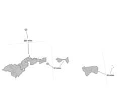
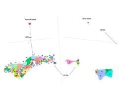
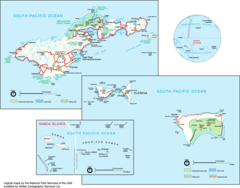
Map & Images (more maps)
As01 109
638 x 379
- 17,139k -
gif
American Samoa Counties1
2112 x 1632
- 27,744k -
png
American Samoa Counties2
1207 x 827
- 5,955k -
png
American Samoa Districts
2112 x 1632
- 20,416k -
png
American Samoa Admin
2112 x 1632
- 19,691k -
png
American Samoa Villages
2112 x 1632
- 34,112k -
png
American Samoa Cia Wfb Map
331 x 355
- 5,473k -
png
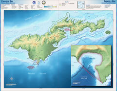
Fagatele Bay Nms Map
2000 x 1550
- 514,733k -
jpg
Map of Usa As
2100 x 1500
- 31,360k -
png
Pago Pago Harbor
1260 x 677
- 227,648k -
jpg
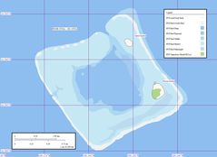
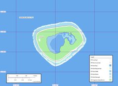
Rose Atoll Map
1240 x 902
- 195,445k -
jpg
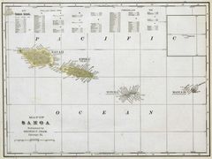
Samoa Cram Map 1896
1600 x 1198
- 137,270k -
jpg
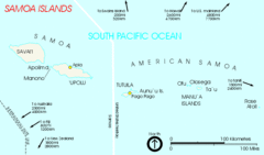
Samoa Islands 2002
709 x 418
- 14,807k -
gif
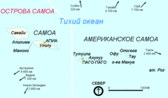
Samoa Islands 2002 3
709 x 418
- 16,621k -
png
Swains Island Map
1240 x 902
- 188,775k -
jpg
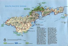
American Samoa Island of Tutuila
1231 x 837
- 158,990k -
jpg
American Samoa Map
1911 x 1496
- 187,454k -
png