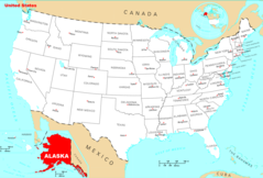
Alaska, US
Alaska: one of fifty states that make up the United States of America.
About
Alaska became the 49th state admitted to the Union on January 3, 1959. It is the largest and most sparsely populated state, known for its rugged natural beauty.
Geography and Climate
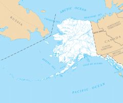
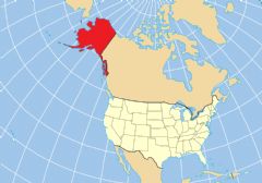
Alaska covers 663,268 square miles of varied terrain including glaciers, mountains, tundras, and forests. It shares an eastern border with Canada and is surrounded by waters such as the Bering Sea, Arctic Ocean and Pacific Ocean.
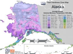
The climate is mostly subarctic with long cold winters and short mild summers. Significant precipitation in the southeast creates the Tongass National Forest, the largest in the U.S.
Economy and Industry
Key industries include oil and gas production, fishing, timber and mining. The Trans-Alaska Pipeline transports crude oil. Commercial fishing of salmon, cod and crab is important. Major companies headquartered in Alaska include Donlin Gold and ConocoPhillips Alaska.
Tourism also thrives in summer with attractions like Denali National Park, Glacier Bay and cruises to spot natural wildlife like polar bears.
Culture and Demographics
Alaska has about 730,000 residents. The largest ethnic group is white at 63%, followed by Alaska Natives and American Indians at 15%. It has a vibrant Native culture with influences from Alaskan Natives, Russians and Americans.
Government and Politics
The state capital and largest city is Juneau located in the Inside Passage region. The current governor is Mike Dunleavy, Republican. Alaska is a solidly Republican state in presidential elections.
Conclusion
In summary, Alaska is the largest and northernmost U.S. state filled with natural wonders. It has an independent pioneering spirit along with Native Alaskan and Russian influences. Abundant wilderness, natural resources and scenic beauty continue to draw adventurous residents and travelers.

State Snapshot
Alaska at a glance
Alaska currently has 172 quality-checked populated place pages and 24 county pages linked on MapSof.
Mapped cities & towns
172
These counts use a stricter populated-place filter so the main lists stay focused on real city and town pages.
County pages
24
Open related pagesLargest city
FairbanksPopulation 30,696
Top linked places
Quick Facts about Alaska
| Population | 731,545 |
| Country | United States of America |
| Different from | Alaska, Alaska |
| Area | 1717856 km2 |
| Water as percent of area | 14.24% |
| Land as percent of area | 85.76% |
| Easternmost point | Point(179.770555555 51.958888888), Point(-129.974194444 55.281944444) |
| Northernmost point | Point(-156.4746 71.387) |
| Latitude & Longitude | 64.0003,-150.0003 |
| Legislative body | Alaska Legislature |
| Official language | English, Gwich’in, Hän, Dena'ina, Upper Kuskokwim, Koyukon, Tanacross, Alutiiq, Ahtna, Aleut, Tsimshian, Tlingit, Inupiat, Yupik languages, Haida, Eyak, Deg Xinag, Tanana languages, Holikachuk |
| Altitude | 1,903 feet / 580 meters |
| Capital | Juneau |
| Establishment | January 03, 1959 (67 years ago) |
| Time Zone | Hawaii–Aleutian Time Zone, America/Anchorage, UTC−09:00, UTC+14:00 |
| Local time | 17:29:56 (28th June 2026) |

Geography
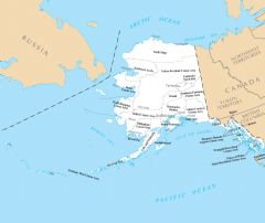
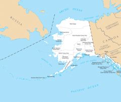
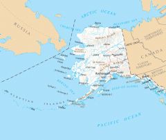
Alaska is located at 64°0'1"N 150°0'1"W (64.0002800, -150.0002800). It has 3 neighbors: Chukotskiy Avtonomnyy Okrug, British Columbia and Yukon.
Alaska map
The largest city of Alaska is Fairbanks with a population of 30,696. Other cities include, Eagle River population 24,793, Wasilla population 11,099, Ketchikan population 8,187 and Kenai population 7,890. See all Alaska cities & populated places.
Largest Cities in Alaska (more)
Cities, Towns, Villages, Neighborhoods & Other Populated Places in Alaska.
| City Name | County | Population |
|---|---|---|
| Fairbanks | Fairbanks North Star Borough | 30,696 |
| Eagle River | Anchorage Municipality | 24,793 |
| Badger | Fairbanks North Star Borough | 19,482 |
| College | Fairbanks North Star Borough | 12,964 |
| Wasilla | Matanuska-Susitna Borough | 11,099 |
| Tanaina | Matanuska-Susitna Borough | 8,197 |
| Ketchikan | Ketchikan Gateway Borough | 8,187 |
| Kenai | Kenai Peninsula Borough | 7,890 |
| Kalifornsky | Kenai Peninsula Borough | 7,850 |
| Palmer | Matanuska-Susitna Borough | 7,766 |
| Meadow Lakes | Matanuska-Susitna Borough | 7,570 |
| Bethel | Bethel Census Area | 6,658 |
| Homer | Kenai Peninsula Borough | 6,034 |
| Kodiak | Kodiak Island Borough | 5,808 |
| Farmers Loop | Fairbanks North Star Borough | 4,853 |
| Soldotna | Kenai Peninsula Borough | 4,790 |
Show more Alaska cities and populated places
Official website of Alaska
Official Website- Lake and Peninsula Borough
- Anchorage Municipality
- Haines Borough
- Wrangell
- Ketchikan Gateway Borough
- Fairbanks North Star Borough
- Sitka
- Matanuska-Susitna Borough
- Juneau
- Bristol Bay Borough
- North Slope Borough
- Kenai Peninsula Borough
- Yakutat
- Petersburg
- Denali Borough
- Aleutians East Borough
- Skagway
- Unorganized Borough
- Northwest Arctic Borough
- Kodiak Island Borough
Demographics
| Year | Population | % Change | Method |
|---|---|---|---|
| 1960 | 226,167 | - | census |
| 1970 | 300,382 | 24.71% | census |
| 1980 | 401,851 | 25.25% | census |
| 1990 | 550,043 | 26.94% | census |
| 2000 | 626,932 | 12.26% | census |
| 2010 | 710,231 | 11.73% | census |
| 2011 | 722,128 | 1.65% | estimation process |
| 2012 | 730,443 | 1.14% | estimation process |
| 2013 | 737,068 | 0.9% | estimation process |
| 2014 | 736,283 | -0.11% | estimation process |
| 2015 | 737,498 | 0.16% | estimation process |
| 2016 | 741,456 | 0.53% | estimation process |
| 2017 | 739,700 | -0.24% | estimation process |
| 2018 | 735,139 | -0.62% | estimation process |
| 2019 | 731,545 | -0.49% | estimation process |
People born in Alaska (59)
People born in Alaska, including film director Mark A.Z. Dippé, fictional character in Star Trek William Riker, strength athlete Jesse Marunde, .
More notable people
- Hope Summers (character from Marvel Comics)
- Reuben Langdon (American stunt man and voice actor) he was born in 19/07/1975
- Andrew Lynch (American singer-songwriter) he was born in 01/01/1953
- Barrett Willoughby (American writer) she was born in 01/01/1886
- Christine Hume (American writer) she was born in 01/01/1968
- Das Williams (Member of California State Assembly) he was born in 29/06/1974
- David Salmon (American politician) he was born in 01/01/1912
- Jennifer Jolly (Journalist and Broadcaster) she was born in 22/02/1971
- Kirsten Gum (Sportscaster, reality show host, raw chef) she was born in 08/12/1972
- Lenne Hardt (American actress)
- Rebecca Rotzler (American politician) she was born in 19/03/1962
- Richard A. Scott (comics artist) he was born in 19/02/1964
- Sue Henry (writer) she was born in 19/01/1940
- Sonihat he was born in 01/01/1855
- Ed Iten (musher) he was born in 01/01/1953
- Robert T. Fletcher III he was born in 27/11/1963
- Sinrock Mary (Reindeer herder) she was born in 01/01/1870
- Takashi Ohno (American politician)
Alaska Counties (more)
Anchorage Municipality

city in Alaska, United States
Matanuska-Susitna Borough

borough in Alaska, United States
Fairbanks North Star Borough

borough in Alaska, United States
| County Name | Population |
|---|---|
| Anchorage Municipality | 287,095 |
| Matanuska-Susitna Borough | 110,213 |
| Fairbanks North Star Borough | 95,651 |
| Kenai Peninsula Borough | 59,414 |
| Juneau City and Borough | 31,849 |
| Bethel Census Area | 18,437 |
| Ketchikan Gateway Borough | 13,747 |
| Kodiak Island Borough | 12,992 |
| Nome Census Area | 9,909 |
| North Slope Borough | 9,294 |
| Valdez-Cordova Census Area | 9,202 |
| Sitka City and Borough | 8,405 |
| Northwest Arctic Borough | 7,644 |
| Southeast Fairbanks Census Area | 6,957 |
| Aleutians West Census Area | 5,680 |
| Yukon-Koyukuk Census Area | 5,077 |
Show more Alaska counties
Map & Images (more maps)
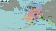
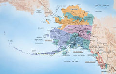
Alaska Regions Map
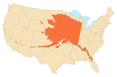
Alaska Area Compared To Conterminous Us
Alaska Map
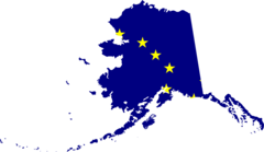
Alaska Flag Map
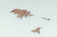
Attu Alaska Relief Map
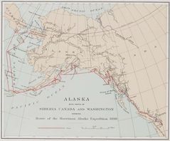
Historical Map Alaska
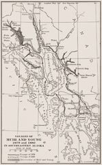
Historical Map Southern Alaska
Where Is Alaska Located
Alaska Counties And Cities
Alaska County Map
Alaska Reference Map
Alaska Rivers And Lakes
Alaska Location Map