Utah, US
Utah: Located in the western United States, Utah is known for its diverse natural landscapes, including the Rocky Mountains and the Great Salt Lake.
About
Utah is a state in the Mountain West subregion of the Western United States. Utah is a landlocked U.S. state bordered to its east by Colorado, to its northeast by Wyoming, to its north by Idaho, to its south by Arizona, and to its west by Nevada. Utah also touches a corner of New Mexico in the southeast.
Utah has a population of 3.151 million as of 2020 and an area of 84,899 square miles (219,873 km2). Salt Lake City is the capital and largest city in Utah, with an estimated population of 1,832,440 as of 2020. Other large cities in Utah include Ogden (253,146), Provo (210,739), West Valley City (159,737), and St. George (130,055).
The dominant religion in Utah is the Church of Jesus Christ of Latter-day Saints (LDS Church). The LDS Church has historically been highly influential in Utah politics and government since territorial days. As a result, Utah's culture is heavily influenced by Mormonism—the majority religion's adherents make up 70%–75% of Utah's population—and Mormon-influenced ideals such as abstention from alcohol use tend to be more socially.
You'll find plenty of things to do in Utah—from skiing in Park City during winter to hiking in Zion National Park during summer (or any time!). There are also many cultural events throughout the year including festivals celebrating everything from quilts to folk music.

State Snapshot
Utah at a glance
Utah currently has 262 quality-checked populated place pages and 29 county pages linked on MapSof.
Mapped cities & towns
262
These counts use a stricter populated-place filter so the main lists stay focused on real city and town pages.
County pages
29
Open related pagesLargest city
Salt Lake CityPopulation 200,567
Top linked places
Quick Facts about Utah
| Population | 3,249,879 |
| Country | United States of America |
| Different from | Eutaw |
| Area | 219653 km2 |
| Water as percent of area | 3.21% |
| Land as percent of area | 96.79% |
| Latitude & Longitude | 39.2502,-111.7510 |
| Legislative body | Utah State Legislature |
| Named for | human |
| Official language | English |
| Altitude | 6,102 feet / 1860 meters |
| Capital | Salt Lake City |
| Establishment | January 04, 1896 (130 years ago) |
| Time Zone | UTC−07:00, America/Denver |
| Local time | 06:06:30 (21st July 2026) |
| Weather | 64℉ Chance Showers And Thunderstorms then Mostly Cloudy 7-days weather |

Geography
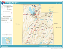
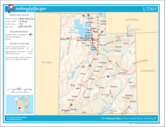
Utah is located at 39°15'1"N 111°45'4"W (39.2502400, -111.7510300). It has 6 neighbors: Colorado, New Mexico, Nevada, Arizona, Idaho and Wyoming.
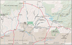
Utah map
The largest city of Utah is Salt Lake City with a population of 200,567. Other cities include, West Valley City population 135,248, West Jordan population 116,530, Provo population 116,295 and Orem population 98,970. See all Utah cities & populated places.
Largest Cities in Utah (more)
Cities, Towns, Villages, Neighborhoods & Other Populated Places in Utah.
| City Name | County | Population |
|---|---|---|
| Salt Lake City | Salt Lake | 200,567 |
| West Valley City | Salt Lake | 135,248 |
| West Jordan | Salt Lake | 116,530 |
| Provo | Utah | 116,295 |
| Orem | Utah | 98,970 |
| Sandy | Salt Lake | 94,871 |
| Saint George | Washington | 92,378 |
| Ogden | Weber | 87,387 |
| Layton | Davis | 79,012 |
| South Jordan | Salt Lake | 78,503 |
| Lehi | Utah | 73,383 |
| Millcreek | Salt Lake | 60,507 |
| Taylorsville | Salt Lake | 59,402 |
| Herriman | Salt Lake | 55,756 |
| Logan | Cache | 51,680 |
| Draper | Salt Lake | 48,963 |
Show more Utah cities and populated places
Weather
A chance of showers and thunderstorms before 7pm. Mostly cloudy, with a low around 64.
7-Day ForecastOfficial website of Utah
Official Website- Beaver County
- Utah County
- Piute County
- Summit County
- Sanpete County
- Millard County
- Sevier County
- San Juan County
- Washington County
- Box Elder County
- Davis County
- Kane County
- Juab County
- Grand County
- Cache County
- Carbon County
- Iron County
- Uintah County
- Tooele County
- Wasatch County
- Emery County
- Morgan County
- Salt Lake County
- Wayne County
- Rich County
- Garfield County
- Duchesne County
- Weber County
- Daggett County
Demographics
| Year | Population | % Change | Method |
|---|---|---|---|
| 1910 | 373,351 | - | census |
| 1920 | 449,396 | 16.92% | census |
| 1930 | 507,847 | 11.51% | census |
| 1940 | 550,310 | 7.72% | census |
| 1950 | 688,862 | 20.11% | census |
| 1960 | 890,627 | 22.65% | census |
| 1970 | 1,059,273 | 15.92% | census |
| 1980 | 1,461,037 | 27.5% | census |
| 1990 | 1,722,850 | 15.2% | census |
| 2000 | 2,233,169 | 22.85% | census |
| 2010 | 2,763,885 | 19.2% | census |
| 2011 | 2,814,384 | 1.79% | estimation process |
| 2012 | 2,853,375 | 1.37% | estimation process |
| 2013 | 2,897,640 | 1.53% | estimation process |
| 2014 | 2,936,879 | 1.34% | estimation process |
| 2015 | 2,981,835 | 1.51% | estimation process |
| 2016 | 3,041,868 | 1.97% | estimation process |
| 2017 | 3,101,042 | 1.91% | estimation process |
| 2018 | 3,153,550 | 1.67% | estimation process |
| 2019 | 3,205,958 | 1.63% | estimation process |
| 2020 | 3,249,879 | 1.35% | estimation process |
People born in Utah (111)
People born in Utah, including horror writer Dan Wells, scientist and businessman Robert W. Gore, inventor Philo Farnsworth, .
More notable people
- Nancy Sullivan (American actress) she was born in 17/10/1969
- Holly Cook (figure skater) she was born in 01/01/2000
- Mervyn S. Bennion (United States Navy Medal of Honor recipient) he was born in 05/05/1887
- Terry de la Mesa Allen (American army officer) he was born in 01/04/1888
- Ethan Van Sciver (American comic book artist) he was born in 03/09/1974
- Manuelito (Navajo leader) he was born in 01/01/1818
- Erv Kanemoto (American motorcycle mechanic) he was born in 07/05/1943
- Dick Kinney (animator) he was born in 20/10/1917
- Frank Zamboni (American inventor and engineer) he was born in 16/01/1901
- Ray Lynch (American musician) he was born in 03/07/1943
- Robert C. Thorne (American paleontologist) he was born in 25/11/1898
- Paul Bloomquist (US army pilot and officer (1932-1972)) he was born in 30/10/1932
- Jon McNaughton (American painter) he was born in 01/01/1965
- Kinji Shibuya (American professional wrestler) he was born in 16/05/1921
- Sam Lufkin (actor (1891-1952)) he was born in 08/05/1891
- Akino (Japanese pop singer) she was born in 31/12/1989
- Brandon Mull (American fiction writer) he was born in 08/11/1974
- Kevin Rollins (American philanthropist) he was born in 15/11/1952
Utah Counties (more)
Salt Lake County

county in northern Utah, United States
Utah County

county in north-central Utah, United States
Davis County

county in northern Utah, United States
| County Name | Population |
|---|---|
| Salt Lake County | 1,165,517 |
| Utah County | 651,059 |
| Davis County | 359,232 |
| Weber County | 262,658 |
| Washington County | 184,913 |
| Cache County | 130,004 |
| Tooele County | 74,512 |
| Box Elder County | 57,007 |
| Iron County | 56,814 |
| Summit County | 42,499 |
| Uintah County | 35,970 |
| Wasatch County | 35,300 |
| Sanpete County | 31,393 |
| Sevier County | 21,780 |
| Carbon County | 20,760 |
| Duchesne County | 19,894 |
Show more Utah counties
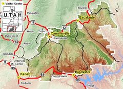
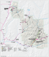
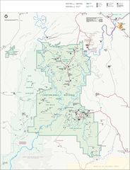
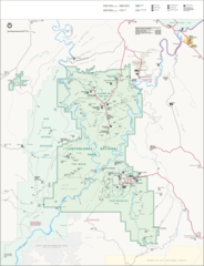
Map & Images (more maps)
Map of Utah Na 1
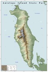
Antelope Island State Park Map
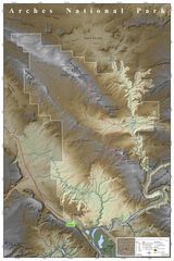
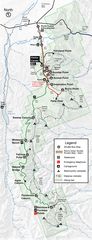
Arches National Park Map
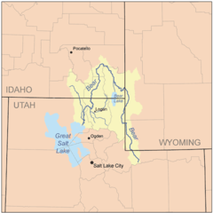
Bearrivermap
Bryce Canyon Road Map
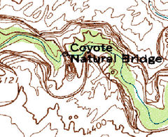
Coyote Natural Bridge Map
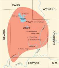
Fremont Culture Region
Gsenm Map
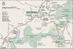
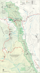
Geography Zion National Park
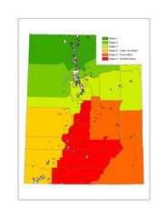
Image Utah Regions
Karte Zion Nationalpark
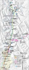
Map Zion Canyon
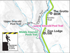
Map Emerald Pool Trail
Map of Canyonlands National Park
Map of Canyonlands National Park 1
Map of Capitol Reef National Park
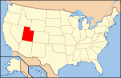
Map of Usa Ut
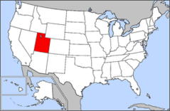
Map of Usa Highlighting Utah
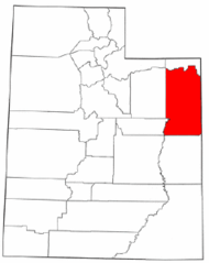
Map of Utah Highlighting Uintah County
Map of Hovenweep Nm