Nova Scotia, Nova Scotia
Nova Scotia: province of Canada
About
State Snapshot
Nova Scotia at a glance
Nova Scotia currently has 1 quality-checked populated place pages and 0 county pages linked on MapSof.
Mapped cities & towns
1
These counts use a stricter populated-place filter so the main lists stay focused on real city and town pages.
County pages
0
Open related pagesLargest city
HalifaxPopulation 424,931
Top linked places
Quick Facts about Nova Scotia
| Population | 957,600 |
| Country | Canada |
| State | Nova Scotia (Canada) |
| Postal code | B |
| Area | 55283 km2 |
| Official name | New Scotland, Nouvelle-Écosse, Alba Nuadh |
| Continent | North America |
| Easternmost point | Point(-59.749 43.984) |
| Northernmost point | Point(-60.150833333 47.202777777) |
| Latitude & Longitude | 45.0002,-62.9987 |
| Legislative body | General Assembly of Nova Scotia |
| Named for | Scotland |
| Official language | English |
| Capital | Halifax |
| Establishment | January 01, 1713 (313 years ago) |
| Time Zone | Atlantic Time Zone |
| Local time | 01:24:27 (10th June 2026) |
Geography
Nova Scotia is located at 45°0'1"N 62°59'55"W (45.000150425, -62.998652994).
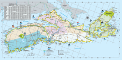
Nova Scotia map
Click "full screen"  icon to open full mode. View satellite images
Largest Cities in Nova Scotia
Cities, Towns, Villages, Neighborhoods & Other Populated Places in Nova Scotia.
| City Name | County | Population |
|---|---|---|
| Halifax | 424,931 |
Official website of Nova Scotia
Official Website- Yarmouth County
- Victoria County
- Digby County
- Cumberland County
- Halifax County
Demographics
| Year | Population | % Change | Method |
|---|---|---|---|
| 1851 | 276,854 | - | census |
| 1861 | 330,857 | 16.32% | census |
| 1871 | 387,800 | 14.68% | census |
| 1881 | 440,572 | 11.98% | census |
| 1891 | 450,396 | 2.18% | census |
| 1901 | 459,574 | 2% | census |
| 1911 | 492,338 | 6.65% | census |
| 1921 | 523,837 | 6.01% | census |
| 1931 | 512,846 | -2.14% | census |
| 1941 | 577,962 | 11.27% | census |
| 1951 | 642,584 | 10.06% | census |
| 1956 | 694,717 | 7.5% | census |
| 1961 | 737,007 | 5.74% | census |
| 1966 | 756,039 | 2.52% | census |
| 1971 | 788,960 | 4.17% | census |
| 1976 | 828,571 | 4.78% | census |
| 2011 | 921,727 | 10.11% | census |
| 2015 | 943,575 | 2.32% | estimation process |
| 2016 | 923,598 | -2.16% | census |
| 2017 | 957,600 | 3.55% | estimation process |
Nouvelle-Ecosse, Nouvelle-Écosse, Nova Escocia, Nova Escòcia
Nova Scotia Counties
| County Name | Population |
|---|
Map & Images (more maps)
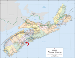
Directional Map of Nova Scotia
2433 x 1899
- 1,018,643k -
png
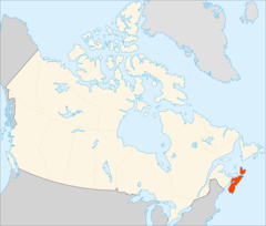
Location of Nova Scotia Canada
1400 x 1188
- 110,508k -
png
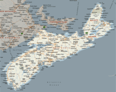
Nova Scotia Map
1000 x 795
- 142,530k -
png
Nova Scotia Map Big
2058 x 1713
- 249,904k -
png
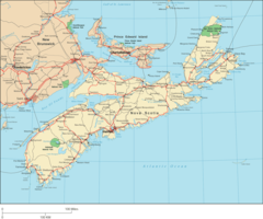
Nova Scotia Travel Map
1650 x 810
- 227,417k -
png