India (Republic of India), IN
India: Independent country in South Asia
About

Quick Facts about Republic of India
| Population : | 1,326,093,247 |
| Country : | India |
| Head of government : | Prime minister of India |
| Plate code : | IND |
| Area : | 3287263 km2 |
| Official name : | بھارت, भारत, भारत, India, भारत गणराज्य, Republic of India, la République de l’Inde |
| Water as percent of area : | 9.5% |
| Land as percent of area : | 90.5% |
| Continent : | Asia |
| Easternmost point : | Point(97.39535585 28.01174361) |
| Northernmost point : | Point(76.78 35.62) |
| Legislative body : | Parliament of India |
| Named for : | Indus River, Bharata |
| Official language : | Hindi, English |
| Capital : | New Delhi |
| Establishment : | August 08, 1947 (76 years ago) |
| Time Zone : | Indian Standard Time |
| Local time : | 11:04:27 (24th April 2024) |

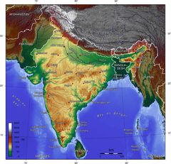
Geography
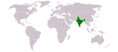
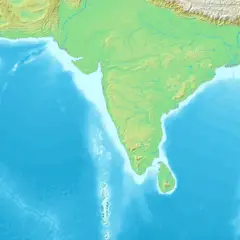
Republic of India is located at 22°0'0"N 79°0'0"E (22.0000000, 79.0000000). It has 8 neighbors: Pakistan, Bangladesh, Sri Lanka, Bhutan, Nepal, Myanmar, Indonesia and China.
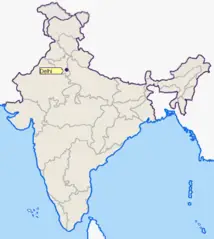
India map
Click "full screen"  icon to open full mode. View satellite images
The largest city of Republic of India is Bengaluru with a population of 11,250,000. Other cities include, Hyderabad population 9,305,000, Ahmedabad population 7,645,000, Surat population 5,935,000 and Kanpur population 2,823,249. See all Republic of India cities & populated places.
- Official Website
Official website of Republic of India
- P. V. Narasimha Rao , 16 May, 1996 1991-06-21T00:00:00Z
- Chandra Shekhar , 21 June, 1991 1990-11-10T00:00:00Z
- Atal Bihari Vajpayee , 22 May, 2004 1998-03-19T00:00:00Z
- I. K. Gujral , 19 March, 1998 1997-04-21T00:00:00Z
- Charan Singh , 14 January, 1980 1979-07-28T00:00:00Z
- Gulzarilal Nanda , 24 January, 1966 1966-01-11T00:00:00Z
- Indira Gandhi , 31 October, 1984 1980-01-14T00:00:00Z
- Rajiv Gandhi , 2 December, 1989 1984-10-31T00:00:00Z
- H. D. Deve Gowda , 21 April, 1997 1996-06-01T00:00:00Z
- Vishwanath Pratap Singh , 10 November, 1990 1989-12-02T00:00:00Z
- Gulzarilal Nanda , 9 June, 1964 1964-05-27T00:00:00Z
- Narendra Modi , Prime minister of India 2014-05-26T00:00:00Z
- Morarji Desai , 28 July, 1979 1977-03-24T00:00:00Z
- Atal Bihari Vajpayee , 1 June, 1996 1996-05-16T00:00:00Z
- Jawaharlal Nehru , 27 May, 1964 1947-08-15T00:00:00Z
- Manmohan Singh , 26 May, 2014 2004-05-22T00:00:00Z
- Lal Bahadur Shastri , 11 January, 1966 1964-06-09T00:00:00Z
- Indira Gandhi , 24 March, 1977 1966-01-24T00:00:00Z
Republic of India has 8 neighbours.
- Islamic Republic of Pakistan Independent country in South Asia
- People's Republic of Bangladesh Independent country in South Asia
- Democratic Socialist Republic of Sri Lanka Independent country in South Asia, situated on an island in the Indian Ocean
- Kingdom of Bhutan Independent country in South Asia
- Federal Democratic Republic of Nepal Sovereign monarchy in South Asia, lasting from 1768-2008
- Union of Burma Independent country in Southeast Asia
- Republic of Indonesia Independent country in Southeast Asia situated on more than 17,000 islands
- People’s Republic of China Independent country in East Asia
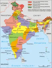
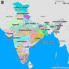
- Assam
- Uttar Pradesh
- Andaman and Nicobar Islands
- Bihar
- Puducherry
- Dadra and Nagar Haveli
- Ladakh
- Jammu and Kashmir
- Kerala
- Sikkim
- Jharkhand
- Andhra Pradesh
- Arunachal Pradesh
- Maharashtra
- Goa
- Meghalaya
- Chhattisgarh
- Jammu and Kashmir
- Daman and Diu
- Haryana
- Manipur
- Uttarakhand
- Himachal Pradesh
- Telangana
- Mizoram
- Tamil Nadu
- Rajasthan
- Nagaland
- Tripura
- Gujarat
- Karnataka
- Punjab
- Madhya Pradesh
- Lakshadweep
- Delhi
- Odisha
- West Bengal
- Chandigarh
Demographics
| Year | Population | % Change | Method |
| 1960 | 449,595,489 | - | estimation process |
| 1961 | 458,626,687 | 1.97% | estimation process |
| 1962 | 467,962,144 | 1.99% | estimation process |
| 1963 | 477,615,992 | 2.02% | estimation process |
| 1964 | 487,607,406 | 2.05% | estimation process |
| 1965 | 497,952,332 | 2.08% | estimation process |
| 1966 | 508,656,247 | 2.1% | estimation process |
| 1967 | 519,722,246 | 2.13% | estimation process |
| 1968 | 531,160,986 | 2.15% | estimation process |
| 1969 | 542,983,934 | 2.18% | estimation process |
| 1970 | 555,199,768 | 2.2% | estimation process |
| 1971 | 567,805,061 | 2.22% | estimation process |
| 1972 | 580,798,773 | 2.24% | estimation process |
| 1973 | 594,192,969 | 2.25% | estimation process |
| 1974 | 608,002,572 | 2.27% | estimation process |
| 1975 | 622,232,355 | 2.29% | estimation process |
| 1976 | 636,883,717 | 2.3% | estimation process |
| 1977 | 651,935,141 | 2.31% | estimation process |
| 1978 | 667,339,022 | 2.31% | estimation process |
| 1979 | 683,032,539 | 2.3% | estimation process |
| 1980 | 698,965,575 | 2.28% | estimation process |
| 1981 | 715,105,168 | 2.26% | estimation process |
| 1982 | 731,443,752 | 2.23% | estimation process |
| 1983 | 747,986,284 | 2.21% | estimation process |
| 1984 | 764,749,394 | 2.19% | estimation process |
| 1985 | 781,736,502 | 2.17% | estimation process |
| 1986 | 798,941,802 | 2.15% | estimation process |
| 1987 | 816,328,792 | 2.13% | estimation process |
| 1988 | 833,833,510 | 2.1% | estimation process |
| 1989 | 851,374,699 | 2.06% | estimation process |
| 1990 | 868,890,700 | 2.02% | estimation process |
| 1991 | 886,348,712 | 1.97% | estimation process |
| 1992 | 903,749,636 | 1.93% | estimation process |
| 1993 | 921,107,534 | 1.88% | estimation process |
| 1994 | 938,452,550 | 1.85% | estimation process |
| 1995 | 955,804,355 | 1.82% | estimation process |
| 1996 | 973,147,577 | 1.78% | estimation process |
| 1997 | 990,460,131 | 1.75% | estimation process |
| 1998 | 1,007,746,556 | 1.72% | estimation process |
| 1999 | 1,025,014,711 | 1.68% | estimation process |
| 2000 | 1,042,261,758 | 1.65% | estimation process |
| 2001 | 1,059,500,888 | 1.63% | estimation process |
| 2002 | 1,076,705,723 | 1.6% | estimation process |
| 2003 | 1,093,786,762 | 1.56% | estimation process |
| 2004 | 1,110,626,108 | 1.52% | estimation process |
| 2005 | 1,127,143,548 | 1.47% | estimation process |
| 2006 | 1,143,289,350 | 1.41% | estimation process |
| 2007 | 1,159,095,250 | 1.36% | estimation process |
| 2008 | 1,174,662,334 | 1.33% | estimation process |
| 2009 | 1,190,138,069 | 1.3% | estimation process |
| 2010 | 1,205,624,648 | 1.28% | estimation process |
| 2011 | 1,221,156,319 | 1.27% | estimation process |
| 2012 | 1,236,686,732 | 1.26% | estimation process |
| 2013 | 1,252,139,596 | 1.23% | estimation process |
| 2014 | 1,263,200,000 | 0.88% | estimation process |
| 2015 | 1,309,053,980 | 3.5% | estimation process |
| 2016 | 1,324,171,354 | 1.14% | estimation process |
| 2017 | 1,339,180,127 | 1.12% | estimation process |
| 2018 | 1,349,217,956 | 0.74% | estimation process |
| 2019 | 1,366,417,754 | 1.26% | (Worldbank) |
| 2020 | 1,326,093,247 | -3.04% | estimation process |
'Inia, 'Initia, An GJo, An India, Barat, Barato, Bharat, Bharato, Buyindi, Ehnehtkhehg, End, Ende, Ennde, Enndo, Eynda, Hinda Unio, Hindia, Hindio, Hindistan, Hindiston, Hindiya, Hindstan, Hindujo, Hindıstan, Hndkastan, Inde, Indi, India, India - bharata, India - भारत, India nutome, Indie, Indien, Indii, Indija, Indiska, Indiya, Indiyan, Indiyān, Indië, Indja, Indland, Indy, Indya, Inia, Inndije, Innia, Intia, Na h-Innseachan, Orileede India, Orílẹ́ède India, Republic of India, Ubuhindi, Union India, Unión India, Yn Injey, Yndia, alhnd, bharata, bharata desam, bharata desamu, bharatam, hindustan, hnd, hwdw, i-India, indo, indoeti, intiya, intya, prathes xindeiy, xindeiy, xingu'e, yin du, Ênnde, Ìndia, Índia, Índɛ, Înde, Ɛndujamana, ʻInia, ʻInitia, Ινδία, Індыя, Індія, Инди, Индия, Индија, Энэтхэг, Үндістан, Ҳиндистон, Ҳиндустон, Һиндостан, Հնդկաստան, אינדיע, הודו, الهند, انڈیا, بھارت, هند, ھىندىستان, ھیندستان, ہِندوستان, ހިންދުސްތާން, भारत, भारतम्, ভারত, ভাৰত, ਭਾਰਤ, ભારત, ଭାରତ, இந்தியா, భారత దేశం, భారత దేశము, ಭಾರತ, ഇന്ത്യ, ඉන්දියාව, ประเทศอินเดีย, อินเดีย, ອິນເດຍ, རྒྱ་གར, རྒྱ་གར་, အိန္ဒိယ, ინდოეთი, ህንድ, ᐃᓐᑎᐊ, ឥណ្ឌា, Ấn Độ, ’Inītia, インド, 印度, ꑴꄗ, 인도
Map & Images (more maps)
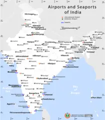
Airports And Seaports Map
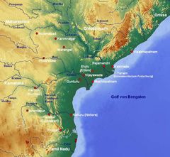
Andhra Pradesh Map
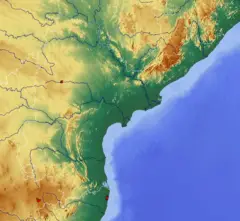
Andhra Pradesh Topographic
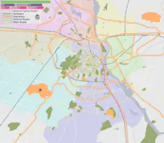
Delhi Area Locator Map
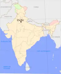
Delhi Location Png
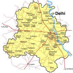
Delhi Map
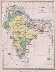
Historical Maps India In 1760
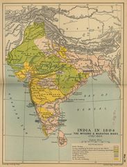
Historical Maps India In 18
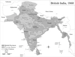
Historic Maps British India
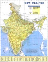
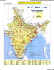
Indian Railways Map
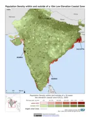
India 10m Lecz And Populati
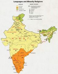
India Languages 1973
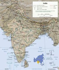
India Map
India Map Bbsr Direct Train Full
India States By Rto Codes
India Topographic
India Topographic Map
Indie 2006
Ind Tou
Location of Delhi Png