Gabon (Gabonese Republic), GA
Gabon: Located on the west coast of Central Africa, it is characterized by its dense rainforests, which cover 85% of the country, and its rich biodiversity.
About

Country Snapshot
Gabonese Republic at a glance
Gabonese Republic currently has 18 quality-checked populated place pages and 9 state or regional pages linked on MapSof.
Mapped cities & towns
18
These counts use a stricter populated-place filter so the main lists stay focused on real city and town pages.
States & regions
9
Open related pagesLargest city
Port-GentilPopulation 109,163
Top linked places
Quick Facts about Gabonese Republic
| Population | 2,469,296 |
| Country | Gabon |
| Plate code | G |
| Area | 267667 km2 |
| Official name | la République gabonaise, Gabon, Repubblica Gabonese |
| Continent | Africa |
| Easternmost point | Point(14.5266 -0.61746) |
| Northernmost point | Point(11.7 2.32) |
| Latitude & Longitude | -1.0000,11.7500 |
| Legislative body | Parliament of Gabon |
| Named for | pea coat |
| Official language | French |
| Capital | Libreville |
| Establishment | January 01, 1960 (66 years ago) |
| Time Zone | UTC+01:00, West Africa Time |
| Local time | 19:58:33 (9th June 2026) |

Geography
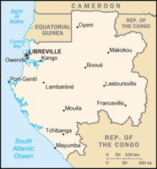
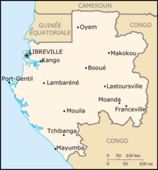
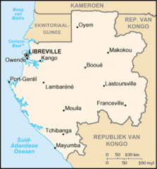
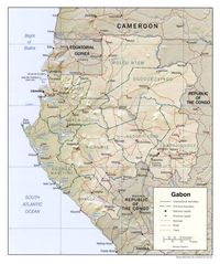
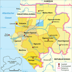
Gabonese Republic is located at 1°0'0"S 11°45'0"E (-1.0000000, 11.7500000). It has 5 neighbors: Cameroon, Congo Brazzaville, Equatorial Guinea, Sao Tome and Principe and Angola.
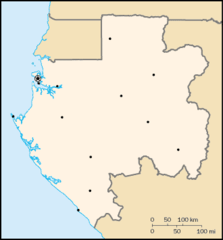
Gabon map
The largest city of Gabonese Republic is Port-Gentil with a population of 109,163. Other cities include, Libreville population 46,428, Franceville population 42,967, Oyem population 30,870 and Tchibanga population 19,365. See all Gabonese Republic cities & populated places.
Compare Gabonese Republic with
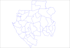
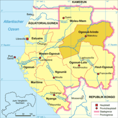
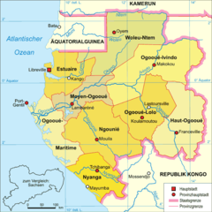
- Woleu-Ntem Province
- Ogooué-Maritime Province
- Ngounié Province
- Estuaire Province
- Nyanga Province
- Moyen-Ogooué Province
- Haut-Ogooué Province
- Ogooué-Lolo Province
- Ogooué-Ivindo Province
Demographics
| Year | Population | % Change | Method |
|---|---|---|---|
| 1960 | 498,823 | - | census |
| 1961 | 503,762 | 0.98% | census |
| 1962 | 509,348 | 1.1% | census |
| 1963 | 515,762 | 1.24% | census |
| 1964 | 523,236 | 1.43% | census |
| 1965 | 531,901 | 1.63% | census |
| 1966 | 541,895 | 1.84% | census |
| 1967 | 553,098 | 2.03% | census |
| 1968 | 565,080 | 2.12% | census |
| 1969 | 577,241 | 2.11% | census |
| 1970 | 589,165 | 2.02% | census |
| 1971 | 600,692 | 1.92% | census |
| 1972 | 611,990 | 1.85% | census |
| 1973 | 623,375 | 1.83% | census |
| 1974 | 635,318 | 1.88% | census |
| 1975 | 648,174 | 1.98% | census |
| 1976 | 662,036 | 2.09% | census |
| 1977 | 676,829 | 2.19% | census |
| 1978 | 692,535 | 2.27% | census |
| 1979 | 709,092 | 2.33% | census |
| 1980 | 726,454 | 2.39% | census |
| 1981 | 744,624 | 2.44% | census |
| 1982 | 763,639 | 2.49% | census |
| 1983 | 783,527 | 2.54% | census |
| 1984 | 804,319 | 2.59% | census |
| 1985 | 826,025 | 2.63% | census |
| 1986 | 848,654 | 2.67% | census |
| 1987 | 872,158 | 2.69% | census |
| 1988 | 896,429 | 2.71% | census |
| 1989 | 921,314 | 2.7% | census |
| 1990 | 946,703 | 2.68% | census |
| 1991 | 972,539 | 2.66% | census |
| 1992 | 998,823 | 2.63% | census |
| 1993 | 1,025,559 | 2.61% | census |
| 1994 | 1,052,772 | 2.58% | census |
| 1995 | 1,080,477 | 2.56% | census |
| 1996 | 1,108,698 | 2.55% | census |
| 1997 | 1,137,412 | 2.52% | census |
| 1998 | 1,166,525 | 2.5% | census |
| 1999 | 1,195,919 | 2.46% | census |
| 2000 | 1,225,527 | 2.42% | census |
| 2001 | 1,255,299 | 2.37% | census |
| 2002 | 1,285,318 | 2.34% | census |
| 2003 | 1,315,820 | 2.32% | census |
| 2004 | 1,347,125 | 2.32% | census |
| 2005 | 1,379,465 | 2.34% | census |
| 2006 | 1,412,907 | 2.37% | census |
| 2007 | 1,447,388 | 2.38% | census |
| 2008 | 1,482,843 | 2.39% | census |
| 2009 | 1,519,155 | 2.39% | census |
| 2010 | 1,556,222 | 2.38% | census |
| 2011 | 1,594,034 | 2.37% | census |
| 2012 | 1,632,572 | 2.36% | census |
| 2013 | 1,671,711 | 2.34% | census |
| 2014 | 1,883,800 | 11.26% | (Worldbank) |
| 2015 | 1,947,686 | 3.28% | (Worldbank) |
| 2016 | 2,007,873 | 3% | (Worldbank) |
| 2017 | 2,025,137 | 0.85% | census |
| 2018 | 2,119,275 | 4.44% | (Worldbank) |
| 2019 | 2,172,579 | 2.45% | (Worldbank) |
| 2026 | 2,469,296 | 12.02% |
Map & Images (more maps)
000 Gaboni Harta
At0126 Map 1
At0723 Map 1
Carte Gabon
Departments of Gabon
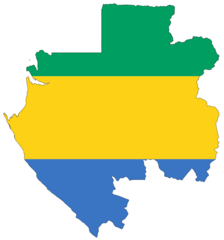
Flag Map of Gabon
Gaboenkaart
Gabon Map
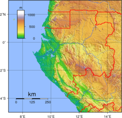
Gabon Topography
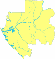
Gabon Blank With Rivers
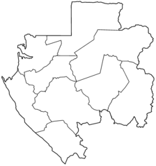
Gabon Provinces Blank
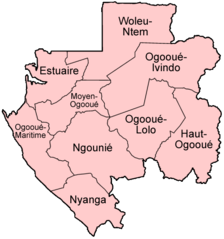
Gabon Provinces Named
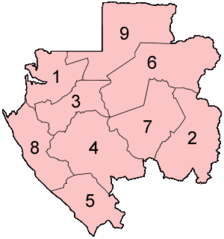
Gabon Provinces Numbered
Gabon Sm05 Tr
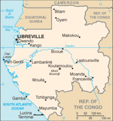
Gabon Cia Wfb Map
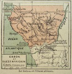
Gabon Ouest Af
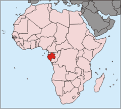
Gabun Pos
Gabun Karte Politisch Ogooue Ivindo
Gabun Karte Politisch
Gabun Karte Politischlo