Athens, Attica
Athens: Located in the Attica region of Greece, this capital city is the historical heart of ancient Greece and a significant center for arts, philosophy, and democracy.
About
Quick Facts about Athens
| Population | 664,046 |
| Country | Kingdom of Greece, Roman Empire, Classical Athens, Duchy of Athens, First Hellenic Republic, Ottoman Empire, Greece, Byzantine Empire |
| State | Attica (Greece) |
| County | Nomarchía Athínas |
| Postal code | 10..., 11..., 120xx |
| Plate code | XP, IE, TT, YH, XY, IM, IK, XE, YA, XH, BM, IY, ZH, IB, XX, XT, BN, IX, OA, YB, ZZ, XZ, IZ, IP, YE, BK, HY, IO, IT, BP, ZM, ZK, IA, YZ |
| Phone Area Codes | 210 |
| Area | 39 km2 |
| Official name | Αθήνα |
| Continent | Europe |
| Latitude & Longitude | 37.9838,23.7278 |
| Named for | Athena |
| Official language | Greek |
| Altitude | 558 feet / 170 meters |
| Capital city | Athens is capital of Second Hellenic Republic, Attica Prefecture, Duchy of Athens, Central Athens Regional Unit, Greek military junta of 1967–1974, Attica Region, 4th of August Regime, Hellenic Republic, Kingdom of Greece, Greece, Athens Municipality |
| Establishment | January 01, -7000 (9026 years ago) |
| Time Zone | Eastern European Time, UTC+03:00, UTC+02:00 |
| Local time | 09:38:44 (10th June 2026) |

Athens Montage L image
Geography
Athens is located at 37°59'2"N 23°43'40"E (37.9837600, 23.7278400).
Athens map
Click "full screen"  icon to open full mode. View satellite images
Official website of Athens
Official Website- Amsterdam
- Amsterdam
- Ashgabat
- Athens
- Atlanta
- Barcelona
- Beijing
- Beirut
- Belgrade
- Bethlehem
- Bogota
- Boston
- Bucharest
- Buenos Aires
- Cali
- Casablanca
- Chicago
- Cluj-Napoca
- Cuzco (1991 )
- Damascus
- Domodedovo
- Famagusta
- Florence
- Genoa
- Havana
- Istanbul
- Kyiv (1996 )
- Lisbon
- Ljubljana
- Los Angeles
- Madrid
- Mexico City
- Montreal
- Moscow
- Naples
- Nicosia
- Prague
- Rabat
- Reggio Calabria
- Rio de Janeiro
- Santiago
- Sarajevo
- Seoul
- Sofia
- Syracuse
- Tbilisi
- Tirana
- Warsaw
- Washington, D.C.
- Xi'an
- Yerevan
Demographics
| Year | Population | % Change | Method |
|---|---|---|---|
| 1856 | 30,969 | - | census |
| 1861 | 41,298 | 25.01% | census |
| 2011 | 664,046 | 93.78% | census |
ATH, Afina, Afini, Afiny, An Aithin, Ateena, Atehny, Aten, Atena, Atenai, Atenas, Atenas - Athena, Atenas - Αθήνα, Atene, Atenes, Ateni, Ateno, Atenoj, Ateny, Athen, Athena, Athenae, Athenai, Athene, Athenes, Atheny, Athina, Athinai, Athinia, Athènes, Athén, Athénes, Athény, Athína, Athínai, Atina, Atény, Atēnas, Atėnai, Aþena, Kota Athena, Lungsod ng Athina, Lungsod ng Athína, atene si, athensa, athyna, atn, etens, xethens, ya dian, Αθήνα, Αθήναι, Αθηνα, Αθηναι, Атина, Атэны, Афины, Афіни, Аѳины, Աթենք, אתונה, آتن, أثينا, ئافېنا, ܐܬܝܢܐ, अथेन्स, ஏதென்ஸ், เอเธนส์, ათენი, Ἀθῆναι, アテネ, 雅典, 아테네, 아테네 시
Other places with the same name (16)
- Athens, Georgia consolidated city-county and county seat of Clarke County, Georgia, United States with a population of 116,714 people.
- Athens, Alabama county seat of Limestone County, Alabama, United States with a population of 28,643 people.
- Athens, Ohio town in Ohio with a population of 24,600 people.
- Athens, Tennessee town in Tennessee, United States with a population of 14,120 people.
- Athens, Texas city in Texas with a population of 12,770 people.
- Athens, New York city in Greene County, New York, United States of America with a population of 3,946 people.
- Athens, Pennsylvania borough in Pennsylvania, United States with a population of 3,180 people.
- Athens, Missouri township in Missouri with a population of 2,080 people.
- Athens, Illinois city in Menard County, Illinois, United States with a population of 1,893 people.
- Athens, Wisconsin village in Marathon County, Wisconsin with a population of 1,079 people.
- Athens, Michigan village in Michigan with a population of 996 people.
- Athens, Maine town in Maine, United States with a population of 976 people.
- Athens, West Virginia town in West Virginia, United States with a population of 890 people.
- Athens, Vermont town in Windham County, Vermont with a population of 435 people.
- Athens, Louisiana village in Claiborne Parish, Louisiana, United States with a population of 265 people.
- Athens, Kansas unincorporated community in Woodson County, Kansas, USA with a population of 47 people.
Map & Images (more maps)
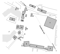
Agoraathens5thcentury
808 x 720
- 27,337k -
png
Atheneoudheid
1200 x 986
- 179,403k -
jpg
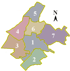
Athens Dimotiko Diamerisma
400 x 405
- 12,425k -
png
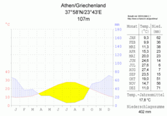
Klimadiagramm Athen Griechenland Metrisch Deutsch
800 x 557
- 20,566k -
png

Localition Atene
170 x 173
- 6,040k -
png
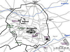
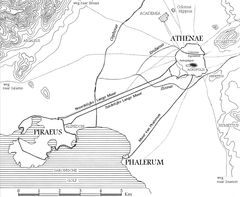
Map Ancient Athens
1000 x 750
- 39,337k -
png
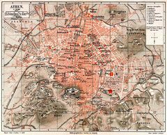
Meyers B1 S0999a
800 x 646
- 222,311k -
jpg
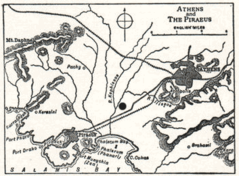
Nsrw Athens
353 x 260
- 40,750k -
png

Athens Metro Map 2007
2000 x 1400
- 99,226k -
png
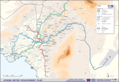
Athens Metro Development Plan
2000 x 1378
- 408,245k -
png

Athens Road Map
1126 x 1551
- 462,692k -
jpg

Athens Metro Map
2400 x 1654
- 536,169k -
png

Athens Metro Map 1
900 x 1351
- 19,176k -
png