Ankara, Ankara
Ankara: Capital of Turkey
About

Quick Facts about Ankara
| Population : | 5,503,985 |
| Country : | Ottoman Empire, Turkey, Ottoman Caliphate |
| State : | Ankara (Turkey) |
| Different from : | Anjara |
| Head of government : | mayor of Ankara |
| Instagram username : | ankarabbld |
| Twitter username : | ankarabbld |
| Postal code : | 06000–06999 |
| Plate code : | 06 |
| Phone Area Codes : | 312 |
| Area : | 25632 km2 |
| Official name : | Angora, Ankara |
| Official language : | Turkish |
| Altitude : | 3,077 feet / 938 meters |
| Capital city : | Ankara is capital of Ankara Province, Turkey |
| Time Zone : | UTC+03:00 |
| Local time : | 15:02:56 (25th April 2024) |

Geography
Ankara is located at 39°55'12"N 32°51'15"E (39.9198700, 32.8542700).
Ankara map
Click "full screen"  icon to open full mode. View satellite images
- Official Website
Official website of Ankara
- Mustafa Tuna , 8 April, 2019 2017-11-06T00:00:00Z
- Mansur Yavaş , 2019-04-08T00:00:00Z
- Melih Gökçek , 6 November, 2017 1994-04-01T00:00:00Z
- Amman (1992 )
- Ashgabat
- Bangkok (2012 )
- Beijing
- Bishkek
- Bissau
- Bucharest
- Budapest (2015 )
- Chișinău
- Damascus
- Dushanbe
- Hanoi
- Islamabad
- Khartoum
- Kinshasa
- Kuala Lumpur
- Kuwait City
- Kyiv (1993 )
- Manama
- Miami
- Minsk
- Mogadishu
- Moscow
- Nicosia
- North Nicosia
- Nur-Sultan
- Pavlodar
- Pristina
- Sana'a
- Santiago
- Sarajevo
- Seoul
- Sofia
- Tbilisi
- Tirana
- Ufa
- Washington, D.C.
Demographics
| Year | Population | % Change | Method |
| 2015 | 5,270,575 | - | Address Based Population Registration System |
| 2018 | 5,503,985 | 4.24% | Address Based Population Registration System |
ANK, Anakara, Ancara, Ancyra, Ang-ka-la, Angkara, Angora, Anguriyah, Ankar, Ankara, Ankara khot, Ankaro, Ankuara, Ankura, Ankyra, Ankyra (Ankyra), Anqara, Enguri, Engüri, Enqere, akara, an ka la, angkala, ankara, anqrh, anqrt, xangkara, Ăng-kā-lá, Άγκυρα (Ankyra), Анкара, Анкара хот, Анкъара, Әнкара, Անկարա, אנקארא, אנקרה, آنکارا, أنقرة, ئەنقەرە, انقره, انقرہ, انکرہ, ܐܢܩܪܐ, अंकारा, আঙ্কারা, ਅੰਕਾਰਾ, ଆଙ୍କାରା, அங்காரா, అంకారా, ಅಂಕಾರಾ, അങ്കാറ, อังการา, ཨན་ཁ་ར།, ანკარა, አንካራ, アンカラ, 安卡拉, 앙카라
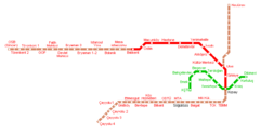
Map & Images (more maps)
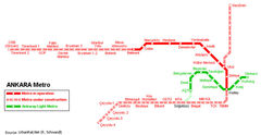
Ankara Metro Map