Adamstown, Maryland
Adamstown: a city in Frederick County, Maryland
About
Adamstown is a city located in the county of Frederick in the U.S. state of Maryland.
Quick Facts about Adamstown
| State | Maryland (United States) |
| County | Frederick County |
| Latitude & Longitude | 39.3109,-77.4747 |
| Time Zone | America/New_York |
| Local time | 09:29:37 (9th June 2026) |
| Postal code | 21710 |
| Weather | 58℉ Mostly Cloudy 7-days weather |
Geography
Adamstown is located at 39°18'39"N 77°28'29"W (39.3109400, -77.4747100).
Adamstown map
Weather
Mostly cloudy, with a low around 58. Southeast wind around 5 mph.
7-Day ForecastBest Things to Do in Adamstown
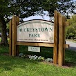
1Buckeystown Park
2171, 7221 Michaels Mill Rd, Adamstown, MD 21710, United States View details
Website available
Nearby Schools and Colleges
Schools and campuses linked to Adamstown, MD. Select a name to open its map and contact details.
| Code | Name | City | ZIP |
|---|---|---|---|
| 455017 | Frederick School of Cosmetology | Frederick (MD) | 21701 |
Nearby Transit Stations (26)
Rail and bus stations connected to Adamstown, MD. Select a station to open its map and address details.
| Code | Name | Address | Type |
|---|---|---|---|
| FRC | Frederick, MD | 100 South East Street | RAIL |
| FRR | Frederick Airport, MD | 1341 Hughes Ford Road | BUS |
| HFY | Harpers Ferry | Potomac St. & Shenandoah St. | RAIL |
| RKV | Rockville station | 251 Hungerford Drive at Park Rd. | RAIL |
| HAG | Hagerstown, MD | 123 West Franklin Street | BUS |
Closest post offices linked to Adamstown.
| Post Office Name | City | ZIP |
|---|---|---|
| Adamstown Post Office | Adamstown (MD) | 21710 |
Other cities in Frederick County
Cities, towns, neighborhoods & other populated places in Frederick County , MD. (more)
| City Name | Population | Title |
|---|---|---|
| Frederick | 73,308 | The second most populous city in Frederick County, Maryland. |
| Ballenger Creek | 18,274 | Town in Frederick County, Maryland, United States |
| Green Valley | 12,262 | Town in Frederick County, Maryland, United States |
| Thurmont | 7,070 | Town in Frederick County, Maryland, United States |
| Brunswick | 6,652 | Town in Frederick County, Maryland, United States |
| Walkersville | 6,574 | Town in Frederick County Maryland |
| Clover Hill | 3,542 | Census designated place |
| Brentwood | 3,439 | Town in Maryland |
| Emmitsburg | 3,270 | Town in Frederick County Maryland |
| Braddock Heights | 2,608 | Town in Frederick County, Maryland, United States |
| Myersville | 1,884 | Town in Frederick County, Maryland, United States |
| Woodsboro | 1,302 | Town in Frederick County Maryland |
| Morningside | 1,279 | Town in Prince George's County, Maryland, United States |
| Rock Hall | 1,255 | Town of the United States |
| Buckeystown | 1,019 | Town in Frederick County, Maryland, United States |
| New Market | 757 | Town in Frederick County, Maryland, United States |